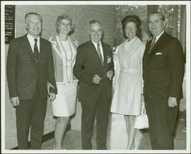
Imprimir vista previa Cerrar

Mostrando 2245 resultados

Archival description
950 resultados con objetos digitales Muestra los resultados con objetos digitales
2000.13.1.27 · Item · 1970
Parte de Ray Williston fonds

Item is a photograph of Mr. Williston (Minister of Lands, Forests & water Resources), Pat Jordan (Minister without Portfolio), Prince George Mayor Harold Moffat, Grace McCarthy (Minister without Portfolio) and Premier W.A.C. Bennett.

Accrual
2002.12 · c. 1970 - 1989
Parte de Bob Harkins fonds

Collection consists of 30 audio cassettes containing 46 interviews conducted primarily by radio & TV broadcaster Bob Harkins with local personalities. Most recordings were conducted at CJCI Studios, Prince George. The station was launched in 1970 by Central Interior Radio, broadcasting on 620 AM. In 1983, Central Interior also launched CIBC-FM in the city. Central Interior Radio was acquired by the Vista Broadcast Group in 2005.

Sin título
2002.12.2.2.1 · Item · c.1970 - c.1989
Parte de Bob Harkins fonds

Item consists of transcript of interview with poet, former CNC faculty member Barry McKinnon conducted by Bob Harkins at Prince George Radio Station, CJCI regarding McKinnon's teaching and publishing careers.

Sin título
2002.12.5.1 · Item · c.1970 - c.1989
Parte de Bob Harkins fonds

Item consists of transcript of interview with Bruce Douglas conducted by Bob Harkins at Prince George Radio Station, CJCI regarding his career in early railways in Prince George region and memories of the sawmills in Giscome area..

Sin título
2002.12.13.1 · Item · c.1970-c.1989
Parte de Bob Harkins fonds

Item consists of transcript and tape summary of interview with Charles, John and Sonya Houghtaling regarding family history; includes stories of his father's work on the Grand Trunk Pacific Railway construction c.1910 and river transportation on the Fraser River as a scowman. Also history of the Houghtaling sub-division

Sin título
Houses
2012.13.1.22.03 · Item · 1970
Parte de J. Kent Sedgwick fonds

Image depicts a number of small houses at Island Cache.

A House
2012.13.1.22.18 · Item · 1970
Parte de J. Kent Sedgwick fonds

Image depicts a house in Island Cache. There are several cars parked outside it.

Sheds
2012.13.1.22.33 · Item · 1970
Parte de J. Kent Sedgwick fonds

Image depicts a number of sheds in Island Cache.

Sheds
2012.13.1.22.36 · Item · 1970
Parte de J. Kent Sedgwick fonds

Image depicts a number of sheds in Island Cache.

City of Prince George
2012.13.2.01.03.3 · Item · [after 1970]
Parte de J. Kent Sedgwick fonds

Map depicts the city of Prince George with annotations of the boundary expansions from 1915 to 1964.

Transportation
2012.13.2.15 · Sub-séries · 1970-2010
Parte de J. Kent Sedgwick fonds

Subseries consists of material collected and created by Kent Sedgwick for research regarding transportation. Includes notes and research on airplanes, specifically Prince George aviation and the Junkers aircraft named "The City of Prince George"; highway transportation; the Grand Trunk Pacific Railway; ferry boat service including the Fraser River Fort George ferry, the Isle Pierre ferry, and the Miworth ferry; the Pacific Great Eastern Railway line; the British Columbia Railway; and the Canadian National Railway. Also includes essays and typed documents on railway history in Prince George.

Prominent Figures
2012.13.2.10 · Sub-séries · 1970-2010
Parte de J. Kent Sedgwick fonds

Subseries consists of materials collected and created by Kent Sedgwick for research on prominent individuals within Prince George and northern/central British Columbia. These individuals include various photographers, John Warren Meyer, Fannie Kinney, Father Adrien Morice, Henry Spencer Palmer, and Bridget Moran. The files also contain various other obituaries and materials regarding prominent individuals in Prince George.

Parks and Outdoor Recreation
2012.13.2.14 · Sub-séries · 1970-2011
Parte de J. Kent Sedgwick fonds

Subseries consists of material collected and created by Kent Sedgwick for research regarding parks and outdoor recreation in Prince George. Material on parks includes Fort George Park (renamed to Lheidli T’enneh Memorial Park in 2015); Cottonwood Island Park; Connaught Hill; Moore's Meadow; L.C. Gunn Park; the Nechako Cutbanks; Paddlewheel Park; Monkman Provincial Park; Fraser Canyon Park; and Carp Lake. Also includes information on the creation of plaques and monuments, including the Alexander Mackenzie monument; the “Arrival of Steel” CN railway plaque; heritage interpretative signs for the Grand Trunk Pacific Railway; the Millar addition; and flooding and rivers. The files consists of various pamphlets and correspondence regarding the development of parks and the creation of interpretive materials.

Slopes
2012.13.1.129.02 · Item · 1971
Parte de J. Kent Sedgwick fonds

Image depicts the slopes of Tabor Mountain in Prince George, B.C.

Tabor Mountain Recreation
2012.13.1.129 · Sub-séries · [between 1971 and 1989]
Parte de J. Kent Sedgwick fonds

File contains slides depicting recreational activities on Tabor Mountain in Prince George, B.C.

Finish Line
2012.13.1.129.01 · Item · 1971
Parte de J. Kent Sedgwick fonds

Image depicts numerous skiers standing near a finish line somewhere on Tabor Mountain in Prince George, B.C.

Cottonwood Island maps and plans
2012.13.2.21.08 · Dossiê · [between 1972 and 1979]
Parte de J. Kent Sedgwick fonds

File consists of maps and plans depicting the Cottonwood Island area in Prince George. Includes:

  • "Plan of Subdivision pursuant to the replotting provisions of the Municipal Act of Parcel A of Plan 25046, of District Lots 343, 662, 1511, 4736, and 7813, Cariboo District" by McWilliam, Whyte, Goble & Associates B.C. Land Surveyors for the City of Prince George, 26 July 1979 (reproduction on 2 sheets)
  • "Cottonwood Island" original draft map with annotations by Kent Sedgwick; the map may have been created by Sedgwick during his time as Senior City Planner with the City of Prince George [197-?]
  • "Prince George B.C., Fraser Subdivision, Mile 146.05" plan for Canadian National Railways by Lockwood Survey Corporation Ltd., 1967. This very large technical drawing shows CN leases and private property buildings on Island Cache in detail.
  • McWilliam-Whyte-Goble & Associates, B.C. Land Surveyors, "Plan Showing Sections in Proposed Lakeland Mill Site", July 1978 (original reproduction).
  • Carroll, Hatch & Associates, "Lakeland Mills (1973) Ltd., Prince George, B.C., Stud Mill Studies, Site Plan", 31 July 1978 (original reproduction).
East Line
2012.13.2.17 · Sub-séries · 1972-2011
Parte de J. Kent Sedgwick fonds

Subseries consists of material collected by Kent Sedgwick for research regarding the communities along the East Line of the Grand Trunk Pacific Railway in Central British Columbia, particularly between Prince George and McBride. These communities and locations include, among others, Shelley, Willow River, Sinclair Mills, Longworth, Dunster, Tete Jaune, Valemount, Mount Robson, and the Yellowhead Pass. Research on these communities was conducted during Kent Sedgwick's involvement in the UNBC-led Upper Fraser Historical Geography Project. The files primarily consist of research notes, audio and transcripts of oral interviews, and photographs of the East Line communities.

From Cutbanks
2012.13.1.3.005 · Item · Apr. 1972
Parte de J. Kent Sedgwick fonds

Image depicts the Fraser River from the vantage point of the cutbanks in Prince George, B.C.

Interview with Reverend F.E. Runnalls
2002.12.23.1 · Item · c.1972-c.1989
Parte de Bob Harkins fonds

Item consists of transcript of recorded interview with Reverend Francis Edward Runnalls who discusses his career as a United Church minister in Prince George c.1920s-1940s. Also discusses his historical works written about Northern British Columbia and Prince George.

Farmhouse
2012.13.1.3.012 · Item · Apr. 1972
Parte de J. Kent Sedgwick fonds

Image depicts a farmhouse on Old Summit Road in Prince George, B.C.

2006.5 · Fondo · 1972 - 1996

Collection consists of records created, received, and collected by the Prince George Women's Centre, the Prince George Women's Collective, the Prince George Women's Equal Rights Association, the Prince George Women's Resource Centre, and the Prince George Women's Connection. This collection also features some materials on the Daughters of Lilith organization.

Sin título
Fishing
2012.13.1.23.15 · Item · 1973
Parte de J. Kent Sedgwick fonds

Image depicts two youths fishing from the bank of the Nechako River on Cottonwood Island.

2012.13.2.21.06 · Dossiê · 1973-1980
Parte de J. Kent Sedgwick fonds

File consists of records created and collected by Kent Sedgwick regarding Cottonwood Island in connection with his employment with the City of Prince George Planning Department. Includes briefs, proposals, memoranda, correspondence, newspaper clippings, questionnaires, legal correspondence, meeting minutes, and photocopied excerpts from maps/plans. Also includes two polaroid photo prints depicting garbage in Cottonwood Island Park circa 1979. Highlights include:

  • Prince George Kiwanis Club, "Brief to City Council, City of Prince George, re: Nechako Riverfront Park", 12 Mar. 1973.
  • New Caledonia Institute of Environmental Studies, "Proposal for Cottonwood Island as a Park Reserve", Summer 1973.
  • "Cottonwood Island Study", [before 1975] (photocopy).
  • Mary Fallis, "Letter to the Editor of The Citizen", 5 Mar. 1976 (photocopy).
  • City of Prince George Planning Department, "Ownership, Legal and Assessment Data - Private and School District Properties within the Proposed Replot Area [Island Cache]", 11 Oct. 1978.
  • "Assessed Values for City and Crown Lands within the Proposed Replot Area North of First Ave" (handwritten table), 16 Oct. 1978.
Nechako River?
2012.13.1.23.08 · Item · 1973
Parte de J. Kent Sedgwick fonds

Image depicts what is possibly a small section of the Nechako River on Cottonwood Island.