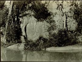
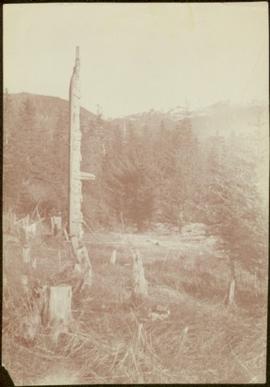
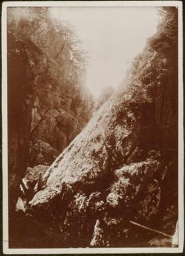
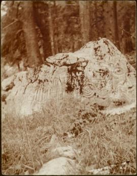
Carvings visible on a moss covered rocky outcrop. Handwritten annotation in pencil on verso reads: “Rock carvings. Copper Mountain, Al”.
Petroglyphs featuring coppers painting onto a rock face next to a lake.
Handwritten annotation in pencil on verso reads: “As seen from the R.R. track. By Harlan I. Smith. 4 poles E of 92 mile or about 1 ½ meter E. of Tyce, B.C., Red Pictograph, Note: head above and to the right at the left of log top in shadow of cedar.” Stamped annotation on verso reads: “Department of Mines Geological Survey Photographic Division, January 21 1926” – in pen above this stamped date is written “7-10-1925”.
Canoes sit on shore in foreground beside village buildings. A dock is visible above water in background.
Handwritten annotation on verso reads: "Alert Bay Indian Ranch No. 14 Alert Bay. To be shown on page 69 or 70, re Alert Bay Mission."
Photograph features rapids in foreground, trees and rocks in background.
Handwritten annotation on verso reads: "A waterfall on American side of the Canal. Chapt. XXVI Waterfall on Alaskan side of Portland Inlet."
Photograph depicts community buildings on shoreline, water in foreground.
Handwritten annotation on image reads: "Wrangle, Alaska."; on verso: "Fort Wrangle, Alaska Territory. visited by W.H.Collison, C.M.S. 1877. Prior to the establishment of any mission, [...? illegible] 1875 - 1876. Presbyterian. Insert this illustration of Wrangle on Page 77 as marked."
Totem poles (crest poles?) stand in front of wooden houses on right. Hills on shoreline visible in background.
Handwritten annotations on verso read: "West Coast QCIs."; "[Old?] Kassan Alaska."
Child stands in distance beside tall totem pole. Tree stumps in foreground, forest and mountains in background.
Handwritten annotation on verso reads: "[Sanabati near Upper Queen?] Kasaan Alaska".
Handwritten annotation on verso reads: "Nass River canyon at flood water". A building is visible on shore in distance, and mountains can be seen in background.
Handwritten annotation on verso reads: "High water on the Nass River". Tree branches in foreground, forest and mountain visible on shore in background.
Handwritten annotation on verso reads: "Lower end of canyon on Naas River. North of Prince Rupert". Forest and mountains visible on shore in distance.
Handwritten annotation on verso reads: "Canyon on Nass River". Forest and mountains visible on shore in distance.
Photograph depicts buildings on shore in background, hills visible in distance.
Handwritten annotation on verso reads: "1st canyon Nass River".
Handwritten annotation on verso reads: "Lava plain Upper Nass River". Forest and hills visible in distance across plain.
Hills on opposite shore in background.
Handwritten annotation on verso reads: "Early steamship off mouth of Nass River".
Group of six men sit and stand on small boat close to shore. Rev. W.E. Collison stands on far right (son of Marion and Archdeacon W.H. Collison).
Handwritten annotation on verso reads: "Dr. Macdonald Med officer (Kincolith) / Dr. [McQuarrie?] Med officer Victoria / Steven Clayton Native boat owner / Capt. Bary - Insp. of Indian Schools / W.E. Collison Indian agent. / Inspection trip to villages of upper Nass River".
Tugboat appears to be towing a long line of small boats.
Handwritten annotation on verso reads: "Fishing fleet coming home Nass River B.C."
Handwritten annotation on verso reads: "Travelling thru' canyon on Nass River 'Engine & poles'".
Hill on opposite shore in background.
Boat floats close to shore in foreground, forest and hills on opposite shore in background. Joyce is the daughter of Bertha and W.E. Collison, and the granddaughter of Marion and Archdeacon W.H. Collison.
Handwritten annotation on verso reads: "Upper Nass River Sept. 1933. Joyce with Tom Moorhouse & the medical officer".
Three men can be seen on deck of small boat. Rocky shore in foreground, forest and hills on opposite shore in background.
Handwritten annotations on verso read: "Dad - en route up Nass River on official business. (hence the flag & business suit!)"; "Going up the Nass. Dad (Indian Agent) Cap Barry (Inspect. of Schools) travelling up the Nass River to Aiyansh".
Forest and hills on opposite shore in background.
Handwritten annotation on verso reads: "poling canoe up Nass River".
Photograph depicts narrow valley between steep cliffs.
Handwritten annotation on verso reads: "on left Vertical side of old Indian fort at Nagas W. Coast Q.C.I".
Landscape featuring town buildings below on right. A farmyard can be seen in foreground.
Photograph depicts boat on right, cannery on left, dock crossing midground in front of both. Shore in foreground, hills in background.
Buildings and harbour visible across water. Unknown man stands in a small boat in foreground, mountains visible in background.
Town on right, water on left, mountains in background. Boardwalk and forest trees in foreground.
Town on right, water on left, mountains in background. Forest trees in foreground.
Handwritten photo caption below image reads: "Port ESSINGTON".
Shops stand along riverside boardwalk. Storefront sign for R. Cunningham & Sons visible. Many people stand and sit on boardwalk, and canoes and small boats float in water in foreground.
Handwritten photo captions beside image read: "R. Cunningham & Sons - Probably Port Essington", "NW coast canoe".
Group of men stand on pier by warehouse, looking out at the boat. Treed mountains visible in background.
Handwritten photo caption beside image reads: "Danube".
Photograph depicts sternwheeler being towed by smaller vessel, shore in background.
Handwritten photo caption beside image reads: "Caledonia".
Photograph depicts sternwheeler, smaller boat, and canoe in foreground. Second sternwheeler named the 'Caledonia' can be seen anchored to shore in background. Town buildings stand on hill in background. Photo believed to have been taken in Port Simpson, B.C.
Perspective of Port Simpson and pier as seen from the water.
Photograph depicts Port Simpson in winter. Water crosses midground, hills stand in background.
Handwritten photo caption below image reads: "Port Simpson".
Photograph depicts Port Simpson in winter. Water and shoreline in foreground, hill in distance.
Handwritten photo caption below image reads: "Port Simpson".
Two men standing beside wheelbarrows with signs that read: “Prince Rupert Transfer Co.” The men appear to be standing on large dock or boardwalk, water and hills in background. Printed annotation on recto reads: “Prince Rupert First Transfer Company.” Handwritten message in pencil on verso is addressed to “Mr. Gordon Penning 1600 Bld. Barclay Vancouver B.C.” Cancelation date on 1 cent Canadian Stamp is dated “Prince Rupert B.C. July 16, 09”.
3 dog teams pulling 3 sleds with 6 men attending. There is a large mountain in the background. Printed annotation on recto reads: “Mail team Skeena River B.C.” Handwritten message on verso is address to “Dear Alice and dated March 23, Easter Sunday 1913”.
View of fish boat in water, with net spread and smaller boat on opposing side of net. Several gulls can be seen flying in the air. Rail cars town and treed hills in background. Printed annotation on recto reads: “Herring Fishing In Prince Rupert Harbour McRae Bros.” Handwritten message in ink on verso is addressed to “Mr. H. Smart 2550 Blackwood St. Victoria B.C.”
View from of a large ship in dry dock surrounded by water. Printed annotation on recto reads: “G.T.P. Dry dock Prince Rupert B.C. McRae.”
Street scene depicts people, boardwalks, tents, and store front. Printed annotation on recto reads: “Centre St. Prince Rupert: B.C., Allen Photos May 17. 09” Handwritten message on verso is addressed to “Dearest Darr”
Boats, docks, ships and a large building in waterscape. Printed annotation on recto reads: “Prince Rupert B.C.” Handwritten annotation in pencil on verso reads: “McRae Bros”.
Lofty view of Prince Rupert BC. Water crosses midground, hills and opposite shore in background. Printed annotation on recto reads: “Prince Rupert BC McRae Bros”.
Lofty view of Prince Rupert BC. Water crosses midground, hills stand in background. Printed annotation on recto reads: “Prince Rupert BC McRae Bros”.
Dock in foreground, ship in water, mountain in background. Unidentified men partially visible in foreground. Printed annotation on recto reads: “Launching of Canadian Scottis –CGM.M. 5500, ton ship at Prince Rupert B.C.”
View from water of large industrial building (cannery?). Handwritten annotation in pencil on verso reads: “Seal Cove BC P. Rupert BC.” Handwritten message in ink on verso is addressed to “Miss Belding 33 Marlbro Avenue Hull Josks Eng.” 2 cancelled Canadian postage stamps read: “Vancouver B.C. Jul 4, 8 PM 1914”
Buildings in foreground, waterscape in midground, trees and snowcapped mountains in background. Printed annotation on recto reads: “Marine and Fisheries Digby Island Prince Rupert B.C. McRae Bros”
Photograph depicts crowds of people walking through street, hills in background. Printed annotation on recto reads: “Centre St. Prince Rupert May Celebrations 1909, Allen Photo July 09.” Handwritten annotation in ink on recto reads: “Prince Rupert 1909”
Printed captions below images on recto read: “Souvenir of Prince Rupert BC; Prince Rupert June 1st, 1909; Prince Rupert Sept 1st, 1913; Public School; Water Front; City Hall; Haye Cove; Margaeto Fleet; Harbour Scene; SS Prince Marquitta at Prince Georg; Sunrise Prince Rupert Harbour; General Hospital; Gold Storage Place; Prince Rupert from Summit”.
Captions below images on recto read: “H.M.C.S. Thiepval. Capt Beech.; In surf Recks and Fog. Wikelski Island; The Aeroplane; Major Stuart MacLaren, and party, at Prince Rupert. B.C.; British Around –the –World, Wrecked Aeroplane”.
Printed annotation on recto reads: “George St. Prince George B.C.”, handwritten in pencil on verso reads: “CA. 1915”
Photograph of George Street in Prince George B.C. Cars, people, and signage are visible. Printed annotation on recto reads: “George St. Prince George B.C. 1921 R7 by Moore” There is an “X” in ink over the fire hall. Handwritten annotation in ink on verso reads: “This view is also looking north and where I have put the X is the one and only fire hall and you can see the fire engine in the street. This is the main street.”