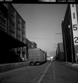
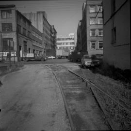
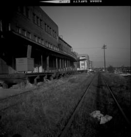
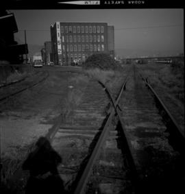
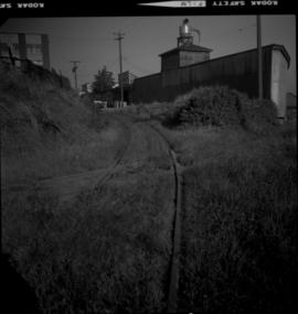
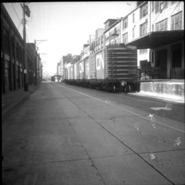
Photograph depicts the CP rail in the False Creek area in Vancouver. It is between Beatty and Cambie Streets with Smithe St. crossing from left to right in the foreground. The photo includes an insulated box car of the Southern Pacific Railway, #SP 67343, built in 1961. The track at the right is physically usable but is unused.
Photograph depicts a view between Drake and Pacific Streets, on the edge of the CPR Drake St. yards in Vancouver. The view is looking east and the Archibald Agencies located at 328 Drake St. are on the left. Some of the rail on the siding is dated 1912, 1911, 1914, which could be the original trackage. The photo is looking down grade to the connection with the yards, immediately west of the Cambie bridge.
Photograph depicts the CP rail and the edge of the Homer St. warehouse complex in Vancouver. The view is looking northeast at the western end of Mainland St. The building is at #1152 Mainland St. The right hand track (man's shadow it) goes down Mainland and is in apparent use. The rail on the left hand track is dated 1938.
Photograph depicts a CPR spur leading to a lane on the east of Richards St in the 1300 block. Much of the trackage here is dated 1911 and may be original. The photo was taken approximately 100 yards southwest of Richards St. and Pacific St. in Vancouver.
Photograph depicts the CPR line on Mainland St. in Vancouver.
Photograph depicts the CPR line in Vancouver. Confusingly, the street is called "Mainland" but the box cars were spotted at the rear of 1152 Hamilton St. The nearest car is a Penn Central 167223, built in November 1972 and behind it is CP 165230 insulated box car. The view is looking northeast.
Photograph depicts Pier B in Burrard Harbour, Vancouver. The photo shows the inside the main roadway and the CPR trackage.
Photograph depicts a CPR rail ferry slip in downtown Vancouver.
File consists of documentary photographs taken by David Davies of ships in British Columbia.
Photograph depicts the Lynn Terminals wharf in Vancouver Harbour. The view is looking east with the Second Narrows bridge in the background. The photo also shows a steam dredger at work.
Photograph depicts Coal Harbour in Vancouver. The view is looking east.
Photograph depicts Coal Harbour in Vancouver. The photo is facing land fill with stone on the tidal side. The site is for the first block of the Harbour Park Development Ltd. high rise apartments.
Photograph depicts the Harbour Park Development site in Coal Harbour, Vancouver. Taking rock from the scow to face fill with anti-erosion material. The site is for new high rise apartments at the edge of Stanley park between Georgia St. and the sea.
Photograph depicts Coal Harbour in Vancouver. The view is looking east at the Bayshore Hotel and facing the Harbour Park Development site, newly filled with rock.
Photograph depicts Coal Harbour in Vancouver. The photo was taken nearly at the head of the harbour on the south side.
Photograph depicts C.N.R. tug #6 on Okanagan Lake at Kelowna. It just had its annual refit. It was built in 1948 by the Yarrows Ltd. in Victoria.
Photograph depicts the C.N. tug "Pentowna" at Okanagan Lake in Kelowna. It is undergoing its annual refit. It was built in 1927 as a lake passenger steamer and converted to a tug at a later date. Her plates are in good condition.. The funnel is to be given the CN insignia.
Photograph depicts a disused C.N.R. rail barge at Tilbury in the lower Fraser River, looking upstream. The shadow is of a bridge, sleeping and messing quarters for the crew. It is not known if the barge is self-propelled but it seems unlikely from its appearance.
Photograph depicts the steam tug "Master" on a Sunday outing near the C.P.R. rail pier at the entrance to Coal Harbour, Vancouver.
Photograph depicts the steam tug "Prestige" at Vancouver Ocean Terminal on the south side of Vancouver Harbour. The disused Indian Arm ferry is alongside.
Photograph depicts the steam tug "Master" tied up to N.H.B. elevator #4 on the southeast side of Vancouver Harbour.
Photograph depicts steam tugs "Master" and "Prestige" at N.H.B. #4 Elevator in Vancouver Harbour. The "Prestige" has not been fired or looked after for at least 2- 3 years and had been moved to this position the previous day after being tied up elsewhere in the harbour in one position for over 12 months.
Photograph depicts the steam tug "Seaswell" on the Pitts River, close to a road bridge. It has not been in used since about 1960/1961.
Photograph depicts the steam tug "Seaswell" on the Pitts River, between a railway and road bridge. It was formerly owned by Vancouver Tug and used for towing log booms in open sea. It was last used by them in 1960/1961. The towing gear was recently removed but the steam reciprocating engines are still intact.
Photograph depicts the steam tug "Prestige" in Vancouver Harbour. It is disused and passively preserved.
Photograph depicts the S.S. "BC Standard" at Westview Harbour, Powell River. The ship was registered in Vancouver.
Photograph depicts the ship the "Princess Louise" under tow by the Vancouver tug "la Pointe", just west of the First Narrows.
Photograph depicts the coasting vessel "Hecate Prince" owned by the Northland Navigation Co. Ltd. at their wharf on the southeast side of Vancouver Harbour.
Photograph depicts a section of floating dock on the north shore of the Vancouver Harbour, between Lynn Terminals and the Second Narrows Bridge. It is one of four sections and arrived here in mid 1965.
Photograph depicts the B.C. Ferry Authority ship the "Comox Queen" at the Little River wharf on Vancouver Island. It is 4 miles north of the village of Comox.
Photograph depicts the ship the "Princess Louise" under tow and just passed under the Lions Gate Bridge in Vancouver.
Photograph depicts the ship the "Princess Louise" prior to departure at Lynn Terminals, North Vancouver. She had been tied to this wharf for at least 18 months.
Photograph depicts the ship the "Princess Louise" under tow by the Vancouver tug "La Pointe", going through the First Narrows. Just before going through the current took her at 45 degrees to the course and for a moment it looked as if she might run aground.
Photograph depicts the ship the "Princess Louise" under tow at about 7:30 pm, passing Brockton Point in Vancouver Harbour.
Photograph depicts the ship the "Princess Louise" at Lynn Terminals in Vancouver Harbour before departure for California. It has one poorly applied coat of white paint. The anchors have been removed and the towing tackle placed in position.
Photograph depicts the ship the "Princess Louise" at Lynn Terminals in Vancouver Harbour.
Photograph depicts the tugboat "Gulf Margaret" with a Straits scow leaving the north arm of the Fraser River and entering the main river at New Westminster, travelling upstream. The tug belongs to the Gulf of Georgia Towing Company.
Photograph depicts the ship the "Princess Louise" at Lynn Terminals in Vancouver Harbour.
Photograph depicts M.V. "Atrevida" at Westview Harbour, Powell River. It connects Westview with Blubber Bay on Texada Island. It is one of the very few ferries not run by the B.C. Ferry Authority. It carries about 6 to 8 cars.
Photograph depicts the North Vancouver Ferry #3 at Western Boat Works at the extreme east end of the Westminster Highway on Lulu Island. It appears to be watertight.
Photograph depicts the North Vancouver Ferry #3 at Western Boat Works in Queensborough. It is used as a tender and workshop.
Photograph depicts North Vancouver Ferry #3 at Western Boat Works in Queensborough on Lulu Island.
Photograph depicts two B.C. Forest Service boats, the "Silver Fir" on the left and the "Cherry II", in Pender Harbour on the Sechelt coast.
Photograph depicts the tugboat "Brunette" at Westview Harbour, Powell River. It is registered in Vancouver.
Photograph depicts the "Nanaimo Chief" at Granville Island, False Creek, Vancouver.
Photograph depicts the close up of the stack, whistle, and wheelhouse of the S.S. Flora Bell in Westview Harbour, Powell River.
Photograph depicts a derelict naval vessel at Wolfson Creek, in the booming grounds of Mahood Logging Co, about 6 -8 miles southwest of Powell River. There is a second identical vessel downstream about 200 yards away.
Photograph depicts the "Queen of Powell River" built in 1965. B.C. Ferry Authority loading at Earls Cove for Saltery Bay (Powell River).
Photograph depicts the B.C. Ferry Authority Vessel M.V. "Jervis Queen" undergoing a refit at Deas Island basin in the Fraser River.
Photograph depicts the S.S. Flora Bell in Westview Harbour, Powell River. It is a steam boat with a vertical tube boiler and driven by a 2 cylinder reciprocating steam engine which came from a U.S. navy pinnace. The engine was built in 1919 at Mare's Island Naval Shipyard in California. The boat runs at about 6 knots.