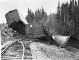
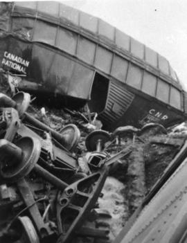
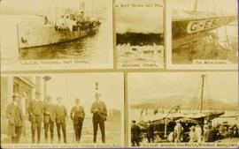
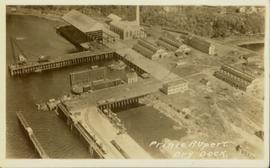
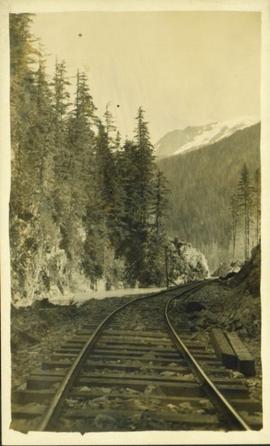
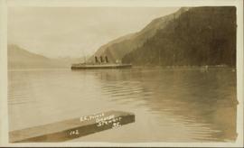
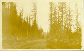
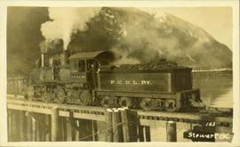
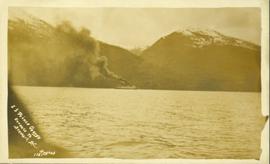
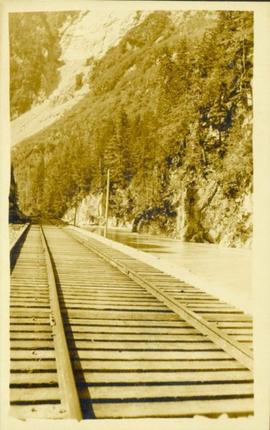
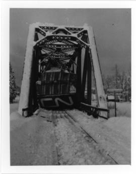
Photograph depicts a Canadian National Railway train derailment on a bridge. Location is unknown.
Photograph depicts a Canadian National Railway train derailment. Location is unknown.
Maps within this series document the placer streams, islands and harbours of the Queen Charlotte Islands; as well as the mining properties located within the vicinity of Stewart, BC.
Photograph depicts a Canadian National Railway train derailment. Location is unknown.
Photograph depicts a Canadian National Railway rail yard at Prince Rupert, BC.
Photograph depicts the Dorreen railway station on the Canadian National Railway main line, located on the west bank of the Skeena River between Cedarvale and Terrace, British Columbia. CN boxcars visible on the siding.
Architectural block plan depicts a proposed addition to the CNR roundhouse in Kamloops.
Captions below images on recto read: “H.M.C.S. Thiepval. Capt Beech.; In surf Recks and Fog. Wikelski Island; The Aeroplane; Major Stuart MacLaren, and party, at Prince Rupert. B.C.; British Around –the –World, Wrecked Aeroplane”.
Elevated view of Third Avenue in Prince Rupert. What appears to be a firetruck is travelling down the road. Printed annotation on recto reads: "3rd Ave W Prince Rupert BC."
Street view of Third Avenue in Prince Rupert. Many vehicles are parked along the wooden sidewalk. Printed annotation on recto reads: "Third Ave. Prince Rupert. B.C."
Street view of Third Avenue in Prince Rupert. A large crowd of people is gathering along the sidewalks. Printed annotation on recto reads: "Third Ave. Prince Rupert. B.C."
Overhead view of the dry dock in Prince Rupert, BC. Printed annotation on recto reads: "Prince Rupert Dry Dock."
Ground level view of the Prince Rupert dry dock. Hills are visible in the background. Printed annotation on recto reads: "Three Million Dollar Dry Dock and Shipbuilding Plant, Prince Rupert, BC."
Water level photograph of several vessels docking in Prince Rupert. The "Co Op Fish Liver Oil" building is visible in the background. Printed annotation on recto reads: "Docks Prince Rupert."
Photograph of a small vessel on the ocean with a dock and harbour buildings in the foreground. Tents and piles of lumber can be seen among the buildings. Annotation on recto reads: "The Wharf, Prince Rupert, BC. 1657."
The photographs depict the geographic areas of Stewart, BC, Boundary Pass, Nelson River, Bitter Creek Glacier, Portland Canal, Red Cliff and Bear Creek; as well as the ships “Camosun” and “S.S. Prince George.” Types of subjects identified in this collection include: community life, surveying, mining and transportation (i.e. dog-sledding, horse and buggy, and the Portland Canal Short Line Railway “P.C.S.L. Rlwy”).
Photograph of a vessel filled with lumber just off the coast of a shore also littered with lumber. Mountains are barely visible in the background.
Photograph of a team of sled dogs pulling a load, followed by a group of men. Mountains are visible in the background. Printed annotation on recto reads: "Trail Over Bitter Creek Glacier to the Naas."
Front view of a stretch of railroad passing through a forested area. Photograph shows a mountain in the background.
Photograph of several full horse drawn carriages parked in front of an unidentified building. Procession may be a parade for some special event.
Photograph of several full horse drawn carriages going over a bridge in Stewart, BC.
Photograph of a stretch of railroad passing by a small body of water. Mountains are visible in the background.
Photograph of a train passing through a forested area.
Photograph of a train passing over a bridge near Stewart, BC. Printed annotation on recto reads: "103 Stewart BC."
Collection of four photographs of the Prince Rupert dry dock. Printed annotation on recto reads: "Dry Dock and Ship Building Plant, Prince Rupert BC."
Ground level view of the Prince Rupert dry dock during what appears to be construction. Printed annotation on recto reads: "The Dry Dock of Prince Rupert."
Photograph of many fishing boats in a harbour. Printed annotation on recto reads: "Prince Rupert Halibut Fleet landing 500,000 LBS. WWW."
Water level photograph of several small vessels gathered around a large cold storage building. Printed annotation on recto reads: "Cold Storage, Prince Rupert B.C. 66."
Street view of Third Avenue in Prince Rupert, BC. Several cars are visible parked along the sides of the paved street. Printed annotation on recto reads: "Third Ave. W Prince Rupert- BC."
Elevated view of the buildings along the Prince Rupert shore, including the Prince Rupert Inn. The waterfront and some small islands can be seen in the background. Printed annotation on recto reads: "Harbour, Prince Rupert, B.C. 1658."
Elevated view of various buildings and vessels along the Prince Rupert waterfront. Several piles of lumber can be seen in the foreground. Printed annotation on recto reads: " Prince Rupert B.C., A busy day on the Waterfront."
Hand coloured side view of various buildings along the Grand Trunk Railway waterfront. Printed annotation on recto reads: "Prince Rupert, B.C. : View from Harbor Grand Trunk Pacific Railway." Artist's stamp on lower right corner reads: "103,113 J.V."
Photograph is a printed postcard depicting the S.S. Prince George at dock in the Portland Canal in Stewart, BC. Annotation written on recto reads: "S.S. Prince George, Stewart, B.C., 102".
Photograph of two horse driven carts driving past a house situated at the foot of a forested mountain.
Front view of two men sitting on a pile of supplies with a mountain in the background. Printed annotation on recto reads: "On the Divide Enroute to Naas #96."
Photograph of the S.S. Prince George traveling through the water. Several mountains are visible in the background. Printed annotation on recto reads: "S.S. Prince George Enroute to Stewart, B.C."
Photograph of several men traveling across a river. Printed annotation on recto reads: "Fording The Nelson River Going to the Naas #93."
Photograph is a printed postcard depicting a section of railroad track going through a mountain pass. Possibly near Stewart B.C.
Postcard taken at the Laggan Subdivision, the most famous photograph location on the CPR system due to its official photographer, Nicholas Morrant, 1910-1986. Possibly a 1920's view. From 1978, this location became known as 'Morant's Curve.' This view was a rarity in showing no train on the track.
File consists of three booklets relating to Mr. Carney Ferry.
File contains postcards portraying life in Prince Rupert, B.C. Images depict harbour scenes, street scenes (Third Avenue, Sixth Street, Central Street, and Mainstreet), airplanes, large ships, fisheries, city aerials, parades, military, a dog sled mail team, and a frozen fishing boat.
Elevated view of Third Avenue in Prince Rupert. Signs for "Chris Mill Bakery" and "Overwaitea" are visible on the left side of photograph. Printed annotation on recto reads: "3rd Ave Prince Rupert BC."
Street view of Third Avenue in Prince Rupert. Printed annotation on recto reads: "60 Post office 3rd Ave Prince Rupert BC."
Street view of Third Avenue in Prince Rupert. Printed annotation on recto reads: "Third Ave Prince Rupert B.C. Photo W.W.W."
Street view taken from the intersection of Third Avenue and Sixth Street in Prince George BC. A drugstore and several cafes can be seen on the left side of the street. Printed annotation on recto reads: "3rd Ave & 6th Street Prince Rupert BC."
Photograph of many fishing boats in a harbour. Printed annotation on recto reads: "Fishing Boats Unloading at Prince Rupert, B.C."
Photograph of a line of rail cars along a track next to a blasted pile of rubble. Printed annotation on recto reads: "Photo by McRae Bros. Prince Rupert." Handwritten annotation on verso reads: "Hello Charly. I have been dead for 2 month and just woke up tell the folks out home I am doing[??] fine. don't know when I will be down again Remember me to the good little woman, and weave[??] all Well. you're[??] friend Stan C." Postcard is addressed to: "Mr. Charles Chislett 96 Colonist Printing Co. Broad Street Victoria B.C." Verso is affixed with a one cent Canadian stamp. Postmark reads: "Prince Rupert B.C. [illegible date]."
Lofty view of the buildings along the Prince Rupert wharf with workers unloading a vessel. Water and mountains can be seen in the background. Printed annotation on recto reads: "Prince Rupert Wharf."
Hand coloured photo of lumber piles and buildings along the edge of the railway. Printed annotation on recto reads: "Prince Rupert, B.C. : View from Wharf Grand Trunk Pacific Railway." Artist's mark in lower left corner reads: "103,110 J.V."
Photograph of many loaded pack horses in front of the "McMillan Transfer Company." Printed annotation on recto reads: "Pack-Train At Bitter-Creek Hughes 116."