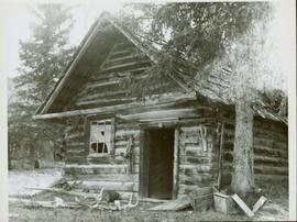
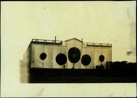
Handwritten photo album caption below this photo reads: "Ordinary 'Nose-Hanger'." Photograph depicts airplane hangar with large circles in a darker fabric to accommodate the nose and engines of plane. Large truck and stacks of unidentified packages in foreground on right. Unidentified vehicle to left of hangar. It is believed that photograph was taken at Whitehorse, YT.
Royal Canadian Air ForceHandwritten photo album caption below this photo reads: "D.O.T [Department of Transportation?] Bldgs & Garage, Whitehorse." Photograph depicts numerous buildings and a four-door garage on streets in Whitehorse. Dump trucks and other various vehicles surround garage. Road and gravel covered area crosses foreground.
Royal Canadian Air ForcePhotograph depicts large group of men gathered outside large building with the sign "WHITEHORSE GRILL".
Handwritten photo album caption below this photo reads: "Dawson Creek BC / 1943 Beer Ration Day".
Photograph depicts building with small second story attached, and a tall red and white pole in front. Signal tower and power poles in background on right, semi-trailer in background on left. A man in uniform can be seen in the far right sitting on a small staircase on wheels. Small unidentified buildings and miscellaneous shop supplies in background. Handwritten photo album caption beside this photo reads: "Grand Prairie Tower and Adm. Bldg."
Royal Canadian Air ForcePhotograph depicts group of buildings at Grande Prairie airstrip. The foremost building has the sign "YUKON SOUTHERN" on its roof, and the tower and admin building can be seen behind. Power poles, large trucks, and other large unidentified machinery are lined up in background on right.
Royal Canadian Air ForceFront view of an abandoned log building. The door is open or missing, the front window glass is broken, the area in front of the building is littered with antlers, boxes and wood. The tree next to the building has grown too close the building and roof. Handwritten annotation on verso in pen reads: “Laketon, Dease Lake, BC. Court house & jail June ‘62”
Photograph depicts man [Gilroy?] sitting with small tin cup. Canoe lies upside down in foreground. Water and opposite shore visible in background. Handwritten annotation visible on negative: "Camp. [Gilroy?] on way up from trail. 9 pm".
Image is one of 65 photos documenting a survey of the Canada-Alaska Boundary, Taku River area, May 23 to Oct. 15, 1906.
This particular photo is one of 13 found in original enclosure with the following handwritten annotation: "SOME OTHERS." See also items 2006.20.3.22 - 2006.20.3.34.
Photograph depicts silhouette of unknown man standing in front of tent, trees in background. Poor image quality.
Image is one of 65 photos documenting a survey of the Canada-Alaska Boundary, Taku River area, May 23 to Oct. 15, 1906.
This particular photo is one of 13 found in original enclosure with the following handwritten annotation: "SOME OTHERS." See also items 2006.20.3.22 - 2006.20.3.34.
Photograph depicts man seated by campfire, duck in hand. Tent buildings can be seen in background. Handwritten annotation on negative: "Billy Pulling ducks".
Image is one of 65 photos documenting a survey of the Canada-Alaska Boundary, Taku River area, May 23 to Oct. 15, 1906.
This particular photo is one of 13 found in original enclosure with the following handwritten annotation: "Kopoka River - river scenes Aug 29 to Oct. 9 [19]06". See also items 2006.20.3.1 - 2006.20.3.13.
Photograph depicts small structure barely visible in forest. Handwritten annotation on negative: "Trappers hut near Kopoka Glacier".
Image is one of 65 photos documenting a survey of the Canada-Alaska Boundary, Taku River area, May 23 to Oct. 15, 1906.
This particular photo is one of 13 found in original enclosure with the following handwritten annotation: "Kopoka River - river scenes Aug 29 to Oct. 9 [19]06". See also items 2006.20.3.1 - 2006.20.3.13.
Photograph depicts small tent set up in bushes, fallen trees in foreground.
Image is one of 65 photos documenting a survey of the Canada-Alaska Boundary, Taku River area, May 23 to Oct. 15, 1906. This particular photo is one of 10 found in original enclosure with the following handwritten annotation: "From [Wahut?]-Azmuth and Koshu.” See also items 2006.20.3.47 - 2006.20.3.56.
Photograph depicts miscellaneous items and supplies in front of white tent. Unknown man stands in foreground and a second man can be seen sitting in tent. Stand of trees in background. Handwritten annotation visible on negative: "[?] Oct 13".
Image is one of 65 photos documenting a survey of the Canada-Alaska Boundary, Taku River area, May 23 to Oct. 15, 1906. This particular photo is one of 9 found in original enclosure with the following handwritten annotation: "Pictures of different members of ‘our’ party.” See also items 2006.20.3.57 - 2006.20.3.65.
Photograph depicts group of six men standing and sitting in forest in front of tent structure with log base. Handwritten annotation visible on negative: "[Myself?] Main Camp".
Image is one of 65 photos documenting a survey of the Canada-Alaska Boundary, Taku River area, May 23 to Oct. 15, 1906. This particular photo is one of 9 found in original enclosure with the following handwritten annotation: "Pictures of different members of ‘our’ party.” See also items 2006.20.3.57 - 2006.20.3.65.
Photograph depicts group of ten men on deck of wood building, cliffs visible in background. One man is only semi-visible through hole in deck, he stands in place of missing plank.
Image is one of 65 photos documenting a survey of the Canada-Alaska Boundary, Taku River area, May 23 to Oct. 15, 1906. This particular photo is one of 9 found in original enclosure with the following handwritten annotation: "Pictures of different members of ‘our’ party.” See also items 2006.20.3.57 - 2006.20.3.65.
Photograph depicts three men sitting in front of tent structure with log base, trees in background. Believed to be main campsite area (see item 2006.20.3.59).
Image is one of 65 photos documenting a survey of the Canada-Alaska Boundary, Taku River area, May 23 to Oct. 15, 1906. This particular photo is one of 9 found in original enclosure with the following handwritten annotation: "Pictures of different members of ‘our’ party.” See also items 2006.20.3.57 - 2006.20.3.65.
Photograph depicts tent among trees, hills visible in background.
Image is one of 65 photos documenting a survey of the Canada-Alaska Boundary, Taku River area, May 23 to Oct. 15, 1906.
This particular photo is one of 13 found in original enclosure with the following handwritten annotation: "Kopoka River - river scenes Aug 29 to Oct. 9 [19]06". See also items 2006.20.3.1 - 2006.20.3.13.
Postcard featuring a photograph of a photograph of the arrival of the first stage coach at the Hotel Northern in South Fort George, BC on 19 October 1911. Handwritten annotation on recto of photograph reads: “Arrival of first stage at So. Ft. George B.C. Oct. 19, 1911. 28” Printed caption on the recto of the postcard reads: “First stage coach Prince George, B.C.” Handwritten annotation in pen on verso of postcard reads: “Mrs. C. Morris, Box 925, Penticton, BC. Thurs. 6pm, Dear Mother. Arr. Safely, good trip (bad pen!) Lovely weather. Hope all are well. Bia (?) Mary & Ed”
Handwritten annotation on recto of postcard reads: “Were there’s a will there’s a way, 5th Street, Prince Rupert, B.C., F. Button photo Pr. Rupert. No. 514.” Handwritten annotation in pen on verso of postcard reads: “Miss Belding, 33 Marlbro Avenue, Hull Yorkshire, England. S.S. Prince George. Dec. 1918. Dear Bertha, This is a street in the centre of the town Prince Rupert. There is a capacity list of passengers on board. The boat is registered to hold 384. We left at midnight and exped to arrive in Vancouver tomorrow at 3:30 pm. Love from Edie.”
Photograph depicts two, four-horse stagecoaches laden with passengers parked outside the Hotel Northern in South Fort George. A group comprised of primarily men watch the stagecoaches from the veranda of the hotel. Handwritten annotation in bottom right corner of photograph reads: "Cariboo Stage at South Ft. George, BC. Oct 19-1911."
Shops stand along riverside boardwalk. Storefront sign for R. Cunningham & Sons visible. Many people stand and sit on boardwalk, and canoes and small boats float in water in foreground.
Handwritten photo captions beside image read: "R. Cunningham & Sons - Probably Port Essington", "NW coast canoe".
Town on right, water on left, mountains in background. Forest trees in foreground.
Handwritten photo caption below image reads: "Port ESSINGTON".
Town on right, water on left, mountains in background. Boardwalk and forest trees in foreground.
Buildings and harbour visible across water. Unknown man stands in a small boat in foreground, mountains visible in background.
Photograph depicts boat on right, cannery on left, dock crossing midground in front of both. Shore in foreground, hills in background.
View of town on shore, from above. Boats docked along piers and buildings. Hills visible on either side of water in background.
Handwritten photo captions with arrows pointing to sections of image read: "General Merchandise", "Fort Wrangell Hotel".
Photograph depicts Port Simpson in winter. Water and shoreline in foreground, hill in distance.
Handwritten photo caption below image reads: "Port Simpson".
Photograph depicts Port Simpson in winter. Water crosses midground, hills stand in background.
Handwritten photo caption below image reads: "Port Simpson".
Perspective of Port Simpson and pier as seen from the water.
Perspective of pier and wharf as seen from the water. Port Simpson and hill in background. Sternwheeler can be seen on shore.
Buildings visible on hillside in background, pier in foreground. Photo believed to have been taken at Port Simpson, B.C.
Photograph depicts sternwheeler, smaller boat, and canoe in foreground. Second sternwheeler named the 'Caledonia' can be seen anchored to shore in background. Town buildings stand on hill in background. Photo believed to have been taken in Port Simpson, B.C.
Photograph depicts a wooden flume funneling water in a forested area. Photo is adhered to paper backing. Original annotations on verso of photo are covered by paper mounting. Typed annotation on recto of paper reads: “First wash for gold by Hixon Creek Cariboo Gold Co. Across Hixon from Quesnel Quartz up the hill. North side of creek 1930’s”
Annotated overview of the Quesnel Quartz Mine Camp, with buildings numbered and a corresponding legend provided. Annotation on recto of photograph states: "1. BRIDGE OVER CREEK 2. BLACKSMITH SHOP 3. POWEROUSE 4. HEADFRAME OVER 200' SHAFT 5. OFFICE 6. WATER TANKS FROM POWERHOUSE 7. BUNKHOUSE 8. TRUCK 9. COOKHOUSE BEHIND #6 CANNOT BE SEEN" Additional annotation associated with photograph states: "We were always able to find the cookhouse even though hidden in this picture. Taken about 1935 by Russell Ross Supt. Quesnel Quartz Mine"
Photograph depicts a dam and wooden spillway along a creek. Annotation on verso reads: "This is the dam and spillway about 9 miles up Hixon Creek belonging to the Hixon Creek Cariboo Gold Co. Original handwritten annotations on verso of photograph are signed by Tom Marsh and covered by mounting the photo on paper. Photograph is taped to paper. Typed annotation on recto of paper reads: “This is the dam and spillway about nine miles up Hixon Creek belonging to the Hixon Creek Cariboo Gold Co., whose main camp on Hixon Creek was at the falls. A fellow Sterling or (Bill) Tordiffe & I took a contract to cut the logs for this dam in January 1934. The first few winters Quesnel Quartz had to shut down for snow."
Photograph depicts a snow-covered forest clearing with six structures and a truck. Buildings have been numbered 1-8 with pen. Original handwritten annotations on verso of photograph are signed by Tom Marsh. Photograph is taped to paper. Typed annotation on recto of paper reads: “1. Bridge over creek. 2. Blacksmith shop. 3. Powerhouse. 4. Headframe over 200’ shaft. 5. Office 6. Water tanks from powerhouse. 7. Bunkhouse. 8. Truck. 9. Cookhouse behind #6 cannot be seen. We were always able to find the cookhouse even though hidden in this picture. Taken about 1935 by Russell Ross, supt. Quesnel Quarts Mine. Tom Marsh, Box 156, Squamish B. C.”
Photo is adhered to paper backing, upon which handwritten annotation on recto reads: “Placer mining Hixon B.C. Hungry 30ies. This picture taken on top of hill across from Quesnel Quartz Mine maybe 800 ft west of Quartz taken approx 45 yrs ago (1933) 1978.12.19”
Photograph depicts two wooden buildings in a snow covered forest environment. Photo is adhered to paper backing, upon which handwritten annotation on recto reads: “Quesnelle Quartz Mining Co. Hixon BCTaken in mid 1930ies. Power house from rear. Present day (1973) Logging road would run through powerhouse at immediate rear of it at which you are looking. Tom Marsh Box 150 Squamish BC 1978.12”
Photograph depicts two wooden buildings in a snow covered forest environment. Photo is adhered to paper backing, upon which handwritten annotation on recto reads: “Quesnelle Quartz mining Company Hixon, B.C. Taken in mid nineteen thirties. Powerhouse from rear. Present day (1973) logging road would run through powerhouse at immediate rear of it at which you are looking. Tom Marsh Box 156 Squamish BC V0N 3G0 December 1978”
Photograph depicts a wooden flume funneling water in a forested area. Photo is adhered to paper backing, upon which handwritten annotation on recto reads: “First wash for gold by Hixon Creek Cariboo Gold Co. Across Hixon from Quesnel Quartz up the hill. North side of creek 1930’s”
Photograph depicts a dam and spillway obstructing a creek. Photo is adhered to paper backing, upon which handwritten annotation on recto reads: “This is the dam and spillway about nine miles up Hixon Creek belonging to the Hixon Creek Cariboo Gold Co., whose main camp on Hixon Creek was at the falls. A fellow Sterling or Bill Tordiffe & I took a contract to cut the logs for this dam in January 1934. The first few winters Quart [sic] Quesnel Quartz had to shut down for snow”
Photograph features interior perspective of the front of an Anglican church as seen from the nave. A large stained glass window, a carved Thuderbird lecturn and the altar are visible.
Unidentified people stand around and between totem poles. A row of buildings and snowy mountain peaks are visible in the background. Location is believed to be Kingcome Indian Village
Photograph depicts an unidentified priest and man standing in the doorway as a small house under construction.
Photograph depicts a log cabin under construction in a cleared area with a forested area in the background.
Photograph depicts a wharf and buildings along the shore of an unidentified fishing community with a forested environment visible in the background.
Photograph depicts an unidentified man standing on the porch of a large house in front of a forest.
Photograph depicts a fishing camp with boats and buildings on floating docks and a forested environment visible in the background. Handwritten annotation on verso states: “1960 Seymour Inlet. Oscar Johnston’s Camp on the Move. Taken from Mission Ship Columbia”; photographer’s stamp on verso states: “W.E. Nicholson”
Photograph depicts a woman wearing a Cowichan sweater rowing a boat away from a rocky island with a lighthouse. Handwritten annotation in pencil on verso reads: “Gal in boat wearing Indian sweater knit by my mother Eileen M. Jackson (she also spun the wool) for her brother J.J. Claxton, cook on the Columbia Coast Mission Boat. - S.K. Jackson”
Photograph depicts a large unidentified house along the shoreline with a forested area in the background.
Photograph depicts an unidentified man, woman, and child sitting on a docked boat. Floating house and workshop visible behind boat while a step forested slope is visible in the background. Photographer’s stamp on verso reads: “W.E. Nicholson.”