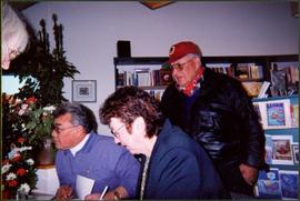
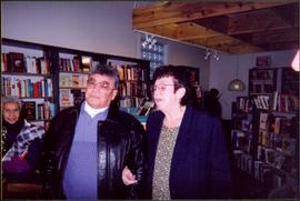
Mostrar 887 resultados

Archival description
887 resultados com objetos digitais Mostrar resultados com objetos digitais
Marching Band
2012.13.1.128.01 · Item · 1994
Parte de J. Kent Sedgwick fonds

Image depicts a marching band with numerous other unidentified individuals. One man is carrying a Canadian flag with the depiction of men in a boat and the words "Canada Sea-to-Sea" on it.

Marching Band - RCMP Chipmunk
2012.13.1.128.02 · Item · 1994
Parte de J. Kent Sedgwick fonds

Image depicts a marching band with numerous other unidentified individuals. One man is carrying a Canadian flag with the depiction of men in a boat and the words "Canada Sea-to-Sea" on it, and there is a mascot beside him that appears to be a chipmunk in an RCMP uniform.

Marching Band
2012.13.1.128.03 · Item · 1994
Parte de J. Kent Sedgwick fonds

Image depicts a marching band with numerous other unidentified individuals. One man is carrying a Canadian flag with the depiction of men in a boat and the words "Canada Sea-to-Sea" on it.

Intercontinental and Prince George Pulp Mills
2012.13.1.5.10 · Item · 6 Sept. 1993
Parte de J. Kent Sedgwick fonds

Image depicts two mills; the Intercontinental Pulp Mill is on the right in the foreground, and the Prince George Pulp and Paper Mill is on the left in the background. The picture is taken from the South, possibly off Yellowhead Bridge in Prince George, B.C.

Prince George Sign
2012.13.1.3.139 · Item · 6 Sept. 1993
Parte de J. Kent Sedgwick fonds

Image depicts the Prince George welcome and population sign, with a population of 71,086. Map coordinates 53°53'52.0"N 122°46'08.7"W

2023.5.1.29 · Item · 1 Nov. 1993
Parte de UNBC School of Planning and Sustainability fonds

This map is part of Schedule B of the 1993 Official Community Plan, Bylaw No. 5909 for the City of Prince George. This particular map depicts the northeast area of the City of Prince George, including the industrial areas on Prince George Pulpmill Road and Northwood Pulpmill Road along the Fraser River.

2023.5.1.28 · Item · 1 Nov. 1993
Parte de UNBC School of Planning and Sustainability fonds

This map is part of Schedule B of the 1993 Official Community Plan, Bylaw No. 5909 for the City of Prince George. This particular map depicts the central area of the City of Prince George, including the Bowl area, the VLA, the Crescents, South Fort George, Heritage, and Peden Hill.

Haldi Lake
2012.13.1.3.137 · Item · 16 June 1992
Parte de J. Kent Sedgwick fonds

Image depicts Haldi Lake near Prince George, B.C.

Eskers Park
2012.13.1.3.138 · Item · 16 June 1992
Parte de J. Kent Sedgwick fonds

Image depicts Eskers Park, near Prince George, B.C.

Bridget Moran Seated at University Women's Club Meeting
2008.3.2.4.2 · Item · May 1989
Parte de Bridget Moran fonds

Photograph depicts Moran seated between two unidentified women at table with pitcher and large open book in front of them. Projection screen stands midground, banners hang on wall in background. Photograph taken during a three day meeting of the B.C. Council of the Canadian Federation of University Women, to honour the 25th anniversary of the Prince George club, and release the new edition of their book 'Prince George Street Names: Our History'. Handwritten annotation on recto of photograph: "4-5 Conf".

Cross Country Skier
2012.13.1.129.21 · Item · 1989
Parte de J. Kent Sedgwick fonds

Image depicts an unidentified man cross country skiing somewhere on Tabor Mountain in Prince George, B.C.

Nechako Cutbanks
2012.13.1.3.090 · Item · 12 Oct. 1989
Parte de J. Kent Sedgwick fonds

Image depicts the cutbanks on the other side of the Nechako, taken from the nature trail at Island Cache. Map coordinates 53°55'34.6"N 122°45'52.4"W

Nechako Cutbanks Trail
2012.13.1.3.092 · Item · 12 Oct. 1989
Parte de J. Kent Sedgwick fonds

Image depicts the cutbanks on the other side of the Nechako, taken from the nature trail at Island Cache. Map coordinates 53°55'34.6"N 122°45'52.4"W

Parkside Intermediate Care Home
2012.13.1.3.101 · Item · 12 Oct. 1989
Parte de J. Kent Sedgwick fonds

Image depicts Parkside Intermediate Care Home on Ospika Boulevard in Prince George. Map coordinates 53°55'02.6"N 122°47'41.6"W

Downtown Prince George Businesses and City Hall
2012.13.1.3.110 · Item · 12 Oct. 1989
Parte de J. Kent Sedgwick fonds

Image depicts George St in downtown Prince George with City Hall in the background. Also visible are the Prince George Hotel, Ming's Inn Chinese Restaurant, Fraser Stationers Ltd., Weiner King food cart, and a movie theatre. Map coordinates 53°54'55.0"N 122°44'36.1"W

Pine Centre Mall
2012.13.1.3.111 · Item · 12 Oct. 1989
Parte de J. Kent Sedgwick fonds

Image depicts Pine Centre Mall in Prince George, B. C. Map coordinates 53°53'53.2"N 122°46'36.4"W

Yellowhead Bridge
2012.13.1.3.120 · Item · 12 Oct. 1989
Parte de J. Kent Sedgwick fonds

Image depicts the Yellowhead Bridge across the Fraser River. Map coordinates 53°54'45.2"N 122°43'27.9"W

Mr. P.G.
2012.13.1.3.122 · Item · 12 Oct. 1989
Parte de J. Kent Sedgwick fonds

Image depicts Mr. P.G. and the Tourism Information site at the intersection of Highway 16 and 97. Map coordinates 53°53'46.5"N 122°46'00.7"W

Experimental Farm
2012.13.1.3.129 · Item · 13 Aug. 1989
Parte de J. Kent Sedgwick fonds

Image depicts a view of an experimental farm, possibly taken from Tabor Mountain.

Prince George
2012.13.1.3.135 · Item · 12 Oct. 1989
Parte de J. Kent Sedgwick fonds

Image depicts Prince George, possibly with the Northwood Pulpmill in the background.

Salvation Army
2012.13.1.3.112 · Item · 12 Oct. 1989
Parte de J. Kent Sedgwick fonds

Image depicts the Salvation Army on Ospika Boulevard in Prince George, B.C. Map coordinates 53°55'02.6"N 122°47'41.6"W.

Central Street West
2012.13.1.3.115 · Item · 12 Oct. 1989
Parte de J. Kent Sedgwick fonds

Image depicts Central Street West, parallel to Highway 97 in Prince George, B.C. looking north. Shown: Prince George Motors and other car dealerships, Burger King, Grama's Inn, and the Spruceland Shopping Mall sign. Map coordinates 53°54'42.1"N 122°46'53.1"W

Foothills Bridge
2012.13.1.3.123 · Item · 12 Oct. 1989
Parte de J. Kent Sedgwick fonds

Image depicts the Foothills Bridge over the Nechako river on the Foothills Boulevard in Prince George, B.C. Map coordinates 53°56'52.5"N 122°48'59.9"W

River
2012.13.1.3.124 · Item · 12 Oct. 1989
Parte de J. Kent Sedgwick fonds

Image depicts a river, possibly the Nechako, in Prince George, B.C. Possibly taken from the Foothills Bridge.

Prince George
2012.13.1.3.133 · Item · 12 Oct. 1989
Parte de J. Kent Sedgwick fonds

Image depicts Prince George, possibly with the Northwood Pulpmill in the background.