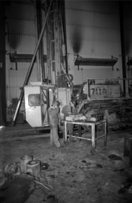
Photograph depicts two unidentified men in coveralls and hard hats, working in garage. Blasthole drill stands behind them in midground, walls in background.
Mill building in left midground. Conveyor believed to be leading to tailings pile can be seen in foreground. Valley and mountains in background.
Cassiar Asbestos Corporation Ltd opened a second mine in 1967 at what became the one-industry town of Clinton Creek, Y.T. File contains photographs depicting different areas of operations at Clinton Creek. Locations include the mine, plant, town, tailings pile, main office, the 40 Mile River, and surrounding area. Town photos depict the grocery store, cafeteria, medical clinic, school, auditorium residential area, Connell Street and power house. File also includes aerial photographs and images depicting forest fighting, photographers capturing the tailings pile, asbestos samples, mining machinery, staff offices, and operations in the mill, lab, and garage.
Additional photographs integrated into file depict Clinton Creek's surrounding area, and three slides of a tailing pile explosion believed to be Clinton Creek.
- File contains photographs done to item level description, depicting miscellaneous people and locations at or around Cassiar, B.C. This includes a photograph of renowned prospector William (“Bill”) Storie, Bill Pratt with a fox, a community gathering in a someone's home, and a hockey game.
- Also included but not to item level is a photo of "David Madore" as part of his application to Cassiar, photo of "William Field" a local hire maintenance mechanic, and photos of a RNWMP Post sign (Royal North West Mounted Police) that depicts annotations "Indian grave" , "Miners Cabin" , "Road House" , "Customs House" , "St. James Church" , "Swansons Store" etc., and 15 negatives of various individuals at what appears to be someone's home.
- Also included is cabin at Boya Lake, which used to be named Chain lake, located off the Stewart-Cassiar highway. This land of this cabin may have been involved legal issues , which was related to people at Cassiar.
Photograph depicts wood houses behind stand of trees in Cassiar valley. Truck, power poles, and road in foreground, mountains in background. Typed caption below photo in original duotang album: "Two Bedroom Pan-Abode Houses - Cassiar Townsite". Handwritten annotation on verso: "Sept 1954".
Photograph depicts a log cabin in the woods with a small porch and moose antlers hanging from the roof.
Photograph depicts group of eight men standing on lawn in front of building known as "House 130" or "Director's Lodge" (see item 2000.1.1.3.19.88). Left to right: Nick Gritzuk, Charles Rainforth Elliot, Jack Christian, W. Harold Connell, Plato Malezemoff (from Newmont Mining), Tam Zimmermann, Ken A. Creery, Fred Martin Connell. Daffodils and tulips planted in foreground, trees and mountains in background. Most men featured in photo are believed to be members of Cassiar's Board of Directors.
Photograph depicts group of eight men standing on lawn in front of building known as "House 130" or "Director's Lodge". Left to right: Nick Gritzuk, Charles Rainforth Elliot, W. Harold Connell, Jack Christian, Fred Martin Connell, Ken A. Creery, Plato Malezemoff (from Newmont Mining), Tam Zimmermann. Trees and mountains in background. Most men featured in photo are believed to be members of Cassiar's Board of Directors.
Blueprint of the Cassiar Recreational Centre depicting various details regarding aspects of the building. Perspectives included within the blueprint are top-down as well as cross-sections. There are notes by the architect towards how certain building aspects and details are to be found and built throughout the blueprint.
This blueprint depicts a cross-section layout of the recreational centre which includes a 1/4 scale drawing of a wall unit.
This blueprint depicts the general layout of the recreational centre. Top-down, side and front perspectives are used. The ground floor, second floor, outside walls and stage layouts are shown. Annotations in gold pen and pencil regarding clarification and changes to certain details are included. Numerical annotation at the bottom right hand of plan imposed new numbering system (3002/09/06).
This blueprint depicts the outside layout of the recreation centre and includes its north, south, east and west elevations. Details are included regarding the materials to be used for construction. Annotations in gold pen and pencil regarding clarification and changes to certain details are included. Numerical annotation at the bottom right hand of plan imposed new numbering system (3002/09/07).
This blueprint depicts a cross-section layout of the recreational centre which includes a 1/4 scale drawing of a wall unit. Annotations in gold pen and pencil regarding clarification and changes to certain details are included. Numerical annotation at the bottom right hand of plan imposed new numbering system (3002/09/09).
This blueprint depicts the overall framing structure of the recreational centre. Details include a cross section layout of the recreational centre with relevant framing dimensions, the locations and instructions for assembly as well as types of framing materials to be used. Annotations in gold pen and pencil regarding clarification and changes to certain details are included. Numerical annotation at the bottom right hand of plan imposed new numbering system (3002/09/10).
This blueprint depicts the gymnasium lighting layout. Also show is an isometric view of the air supply unit piping as well as a ventilating unit automatic control diagram. Included are detailed notes regarding system desriptions, its plan and layout as well as directions for the automatic control of the ventilation unit and heating systems. Annotations in gold pen and pencil regarding clarification and changes to certain details are included. Numerical annotation at the bottom right hand of plan imposed new numbering system (3002/09/12).
This blueprint shows the side profile of the proposed tramway to be built in Cassiar. It includes scale drawings of the crusher building, power house and support structures. The degree of tilt of the support structures are marked down where applicable. The side profile is divided into five sections due to the scaled height in elevation and the lack of drawing space. Annotation written along the leading edge of the blueprint reads "Proposed Tramway Riblet".
This blueprint shows the front and side profiles of the proposed jig back bucket for use in the tramway. Relevant measurements and dimensions are included as well as location placements for the track stand and traction rope.
This blueprint shows the top-down (showing the plan view) and the side view (showing elevation) of the transfer station layout. The process and operation of the jig back discharge and monocable loading are also included. Relevant measurements and dimensions are included as well as locations of the loading chute, the loading area, monocable as well as empty and loaded rope lines.
Item is a photograph of the Bennett Dam.
Item is a photograph of the construction of the W.A.C. Bennett Dam
Item is a photograph of a pile of bamboo in a field.
Item is a photograph of a house under construction. Unknown individual sits on ground in foreground.
Item is a photograph of people and boats on a river’s edge.
Item is a photograph of street vendors.
Item is a photograph of building construction with bamboo scaffolding.
Item is a photograph of Prince George taken from the air, looking east with the Cameron Street Bridge in the foreground.
Item is a print of a photograph of a building described on verso as the Post Office [?] in Prince Rupert in 1908.
Item is a photograph of a building with trees in front covered with snow.
Item is a photograph of the grade 8 class at Princeton Junior High School taken in May of 1941 with their teacher Ray Williston.
Photograph depicts Moran walking away from round entrance to long house, unidentified individual visible inside.
Photograph depicts Moran wearing regalia, standing to right of family members in the Agora courtyard at the University of Northern British Columbia in Prince George, B.C. Sons Mike (wearing black) and Pat stand on left, and Paul Ramsey stands in center. Unidentified individuals stand near Winter Garden in background. Photo taken on the day Moran received an Honourary Law Degree.
Photograph depicts ranger Alex Nelles' log cabin covered with snow and ice. Surrounding the cabin are cabin are several loaded packs and a horse.
Footage of a group of swans on a lake, possibly Anahim Lake. Footage of what is believed to be Al Elsey's front yard.
Photograph depicts a wood planked building on pilings under construction in a forest clearing.
Photograph depicts several wooden buildings on the shoreline with a forested area in the background.
Photograph depicts the wooden Hagwilget Bridge spanning a rocky gorge over the Bulkley River. Forested area visible in the background. Annotation on recto of photograph states: "W.W.W. Old Indian Bridge, Bulkley River"
Photograph depicts a wooden building under construction and piles of wood planks on the shoreline.
Photograph depicts a lighthouse on a rocky shoreline with a forested area in the background. Annotation on verso of photograph states: "Driad Pt. light near Bella Bella kept by B.B. indian"
Photograph depicts two large snowbanks flanking a walkway with houses visible in the background.
Photograph depicts several buildings along a forested shoreline with a church in the background.
Photograph depicts the multi-level Prince Rupert hospital with trees and shrubbery in the foreground. Annotation on recto of photograph states: "Prince Rupert Hospital W.W.W. Photo"
Photograph depicts a multi-level hospital surrounded by smaller buildings and a wooden walkway. Annotation on recto of photograph states: "Methodist Hospital, Bella Bella B.C. George E. Darby, B.A., M.B., Superintendent"
Young Hugh Jr. sits with cat on knee, on wood steps in front of doorway to unidentified building. Handwritten caption below this photo reads: "Hugh - 1931."
Photograph depicts a boy believed to be Hugh Taylor Jr wearing skis, goggles, and holding poles. The side of a snow-covered car is visible on left. A house and two wood buildings stand in background in front of trees.
Back, left to right: Ellen (nee Taylor) and husband Percy Garland, Joan Graves (daughter of Lucy Taylor), Dick Baxter (son of Violet), Violet (nee Taylor) Baxter. Front, left to right: [unknown], Margret Baxter (wife of Alan Baxter), Judy Taylor (daughter of Arthur Taylor), Edna Roth (daughter of Violet).
Photograph taken on Ross Crescent, Prince George, at the home of Violet Baxter. Car and trees in background.
Hermina Taylor is seated on chair in front of house at South Fort George. Dixon and Arthur stand behind her, and Tom beside. Handwritten annotation on recto of photograph: "Mother and my three brothers."
Group of women and children sit on steps in front of unidentified building. Hermina Taylor holds one year old Dixon. Five year old Ellen sits behind Hermina and between two unidentified women, one of whom holds four year old Violet. Ellen holds a doll.
Each child is dressed in white and seated on deck in front of wood building. In descending order: Ellen, Violet, and Lucy. A barn, fence and forest can be seen in background. It is believed that the children are sitting in front of their home in Kispiox, B.C. See also items 2009.5.1.45 & 2009.2.1.46.