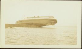
Showing 3619 results

Archival description
Unknown Men at Mine Adit
2009.5.2.39 · Item · 1939
Part of Taylor-Baxter Family Photograph Collection

Photograph depicts four men wearing suits and ties, standing in front of mine adit in rocky area, bushes in background. Handwritten annotation on recto of photograph: "1939 H.F. (Bert) Glassey with black hit in middle" (information regarding Glassey believed to be incorrect).

Unknown Woman & Men at Mine
2000.1.1.3.15.02 · Item · 1954
Part of Cassiar Asbestos Corporation Ltd. fonds

Photograph depicts a man and woman standing on what is believed to be an early mining bench. Two men with air track drill can be seen in background, one man father down on left, mountain range in background. Image slightly distorted due to poor quality of negative.

Upper Fraser General Store
2012.13.1.87.043 · Item · [between 1975 and 1995]
Part of J. Kent Sedgwick fonds

Image depicts the Upper Fraser General Store in Upper Fraser, B.C. Two other signs indicate that it is also a post office and a place that offers propane refills. Map coordinates 54°07'10.8"N 121°56'51.7"W

Upper Fraser Mill
2012.13.1.87.044 · Item · [between 1975 and 1995]
Part of J. Kent Sedgwick fonds

Image depicts entrance to mill yard for Upper Fraser mill in Upper Fraser, B.C. Map coordinates 54°07'10.8"N 121°56'51.7"W

Upper Fraser Mill
2012.13.1.87.046 · Item · [between 1975 and 1995]
Part of J. Kent Sedgwick fonds

Image depicts Upper Fraser mill yard with log deck and beehive burner in silhouette across railroad tracks. Located in Upper Fraser, B.C. Map coordinates 54°07'01.5"N 121°56'29.6"W

Upper Fraser Mill
2012.13.1.87.064 · Item · [between 1975 and 1995]
Part of J. Kent Sedgwick fonds

Image depicts numerous log decks at the Upper Fraser sawmill. Map coordinates 54°07'10.8"N 121°56'51.7"W

Upper Fraser Mill
2012.13.1.87.062 · Item · [between 1975 and 1995]
Part of J. Kent Sedgwick fonds

Image depicts the entrance to the Upper Fraser mill yard in Upper Fraser, B.C. Map coordinates 54°07'10.8"N 121°56'51.7"W