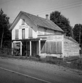
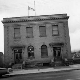
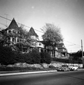
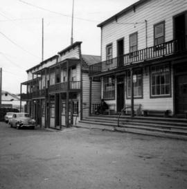
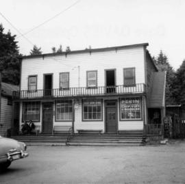
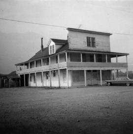
Photograph depicts the former "Terminus Hotel" on 32 Water St., 50 yards from the center of old Vancouver.
Photograph depicts the Mussenden Building used by the Hudson's Bay Company. It is located on Water St. in Vancouver, B.C. View is from the north side looking east.
Photograph depicts an old church or school being demolished at 1701-1721 West 3rd Ave. (and Pine), in Vancouver, B.C.
Photograph depicts a stone house on 17th St. and Esquimalt St. in West Vancouver, B.C.
Photograph depicts the Wheatsheaf Inn "pub" on the way to Cedar-by-the-Sea from Nanaimo, B.C.
Photograph depicts Chinatown in Duncan, B.C. on Vancouver Island.
Photograph depicts the Chinatown in Duncan on Vancouver Island.
Photograph depicts a grocery store on the main street of Pitt Meadows in the Fraser Valley.
Photograph depicts the water tower at B.C. Forest Products Ltd. Mill at Port Hammond, in the Fraser Valley.
Photograph depicts the corner building on West Georgia and Chilco St., facing Stanley Park in Vancouver B.C. View looking south across Georgia St.
Photograph depicts a church or school on the south side of Craigflower Rd. in Victoria B.C. It is near or on the Songhees Reserve.
Photograph depicts a former hotel, 300 yards from the former government wharf, in Squamish, B.C.
Photograph depicts an implement shed at Cloverdale in the Fraser Valley on the Pacific Highway.
Photograph depicts a disused general store at Coghlan, 5 miles southeast of Fort Langley in the Fraser Valley.
Photograph depicts the Windsor Hotel at Fort Steele, 10 miles northeast of Cranbrook. It was built in 1895 by Robert D. Mather and originally was called Dalgarno House. It is being renovated as a village museum.
Photograph depicts the Pacific Press Ltd. Vancouver Sun building at Beatty and West Pender St. The view is looking northeast from Beatty St. It was vacated by the Vancouver Sun at Christmas 1965 with the neon "Sun" sign on the tower removed.
Photograph depicts Pier B of C.P.R., just west of the C.P.R. railway station. This is the only pier accessible to ocean going passenger liners and is used by P&O vessels. Facilities generally in adequate for the 1960s.
Photograph depicts a former fire hall now used as a boy's club on 12th Ave and St. Catherine's St., in Vancouver, B.C. It is one and a quarter miles southeast of C.N.R. station.
Photograph depicts St. Paul's Anglican Church in Powell River. The church was built in 1955.
Photograph depicts a Roman Catholic church, "Our Lady of Lourdes," on the First Nations reservation, Sechelt Village. It was built in 1907 and is now closed, but the heavy bell is still in position in the belfry.
Photograph depicts a barn at Lund, a village 12 miles north of Powell River. This building overlooks the harbour.
Photograph depicts a house on Ladner Trunk Rd. in Delta, B.C. It is in the northeast corner of an intersection with the road leading to the Canadian Army Signal Station.
Photograph depicts the B.C. Forest Service Ranger's administration and equipment building at Pender Harbour in Sechelt, B.C.
Photograph depicts a settler's log cabin, about 1 mile from the main road of Sechelt Peninsula and on the side road leading to Gordon Bay, at a point where a small stream cease to be tidal. Vertical cracks in logs stuffed with rags and horizontal cracks filled with cement.
Photograph depicts a Chinese farmer's buildings on the Port Guichon Rd. on the outskirts of Ladner, B.C.
Photograph depicts a post office on Main St. in Cumberland on Vancouver Island. It was built in 1907 in a similar style to the building in Ladysmith.
Photograph depicts a Ukrainian Greek Orthodox Church on 27th St. and 41st Ave. in Vernon, B.C. in the Okanagan.
Photograph depicts the brick works at Haney, B.C., within 100 yards of the Fraser River. Current production appeared to be bricks, tiles, and flowerpots. There is a disused railway spur in the works
Photograph depicts the McCulloch CPR depot located at mile 76.7 on the Carmi Subdivision, which is about 27 miles northeast of Penticton. The rear building is the passenger depot, which was painted blue inside. The view is looking north.
Photograph depicts a booster telegraph relay station at Carmi. Carmi is located at mile 46.6 on the CPR line on the Carmi Subdivision. This is the only surviving telegraph pole between Penticton and Beaverdell. The view is looking east.
Photograph depicts the Carmi Depot located at mile 46.6 on the CPR line in the Carmi Subdivision. This is the only surviving building at the depot. The layout here consisted of 4 passing/storage tracks and 1 short siding. The view is looking north and upgrade.
Photograph depicts the CPR line at Boundary Falls, which is at mile 121 from Nelson on the Boundary Subdivision. The view is looking west and it shows the former flag stop shelter.
Photograph depicts the Fernie CPR station, located at mile 34.7 on the Cranbrook Subdivision, which runs from Crowsnest to Cranbrook. In coal mining days this was a busy place but now it has sidings for 153 cars and nothing else. The view is looking east.
Photograph depicts the Creston Sawmills Ltd on the CPR line. Here the southern BC CPR mainline passes through the center of trackage, looking eastbound. A chip car is on the spur directly leading from the camera.
Photograph depicts a courthouse in Vancouver, B.C. Photo shows the ripped up forecourt.
Photograph depicts a courthouse on Georgia St., looking west towards the Vancouver Hotel. The fence surrounding the courthouse is covered with paintings.
Photograph depicts a painting on the fence outside a courthouse on Howe and Granville St. In Vancouver, B.C. Each artist was granted a permit and panel by City Council.
Photograph depicts a wharf at Lang Bay, 14 miles southeast of Powell River. In fair repair, now used only by an oil company to pump in oil to a storage depot behind the camera.
Photograph depicts a general view of Coal Harbour in Vancouver, taken from its head in Stanley Park, looking east. The Bayshore Inn is shown on the extreme left of the image.
Photograph depicts a house fire possibly on 1000 Beach Block and Thurlow St. , caused by a wrecking gang.
Photograph depicts the 1000 Beach Ave. block with dogwood rose tree in bloom at the left of the photo.
Photograph depicts an empty site at 1000 Beach Ave. in Vancouver, B.C.
Photograph depicts the upper end of Coal Harbour, on the south shore looking southwest and taken from the dock of the Vancouver Shipyards Ltd.
Photograph depicts a view looking northeast towards Coal Harbour from Alberni St. (Chilco-Gilford block) with West Georgia St. in the middle distance.
Photograph depicts a general view of Coal Harbour in Vancouver, looking southeast and taken from Royal Vancouver Yacht Club premises. Photo shows the Bayshore Hotel on the extreme left.
Photograph depicts the sluice gates off the Nicola River, on a ranch at Nicola village, 7 miles northeast of Merritt.
Photograph depicts the north shore of False Creek, looking west after a snowfall. Photo taken from the swing span of Cambie Bridge in Vancouver, B.C.
Photograph depicts block ships sunk to protect booming grounds at Powell River. The ships were former wartime naval vessels.
Photograph depicts a general view, looking north, of Westview Harbour with the Powell River paper plant smoking in the background.
Photograph depicts the newsprint plant of MacMillan, Bloedell, and Powell River Ltd. In Powell River, B.C. The view is looking northwards and shows that the plant is working on Easter Day/