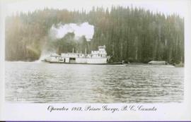
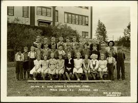
Fred stands smiling on far left, Alan wears a white shirt seventh from left in first standing row. Bushes and hedges stand behind them in midground. Large school building stands in background on left, power poles on right. Handwritten annotation on recto of photograph: "DIVISION. 9. KING GEORGE V ELEMENTARY SCHOOL. PRINCE GEORGE. B.C. SEPTEMBER. 144. PHOTO BY BRIDGMAN VANCOUVER. B.C."
Postcard photograph depicts sternwheeler in river, trees on opposite shore in background.
Printed annotation on recto reads: “Operator 1913, Prince George, B.C. Canada”, handwritten in pencil on verso: “Operator 1913”.
Overhead photograph of Prince George, BC ca. 1950 with hills in background. Annotation on recto reads: "Prince George, B.C."
Fonds consists of personal papers, books, manuscripts, photographic materials, audio recordings and electronic records arranged into five series, which relate to Mr. Fawcett's personal life, his creative works and his relationships with members of the literary community.
Zonder titelPhotograph depicts Iona Campagnolo, Pierre Trudeau and Ron Basford talk with an unidentified crowd of children and adults at a children's speed skating event during the 1978 Northern BC Winter Games.
Photograph depicts Prime Minister Pierre Trudeau, Evelyn Basso, and a man standing in a crowd at a Northern BC Winter Games event in Prince George.
Photograph depicts a disused snow plow #6001 that was built of wood. Snow plough #6002 is found behind.
Photograph depicts the CNR depot. Considerable renovation work was taking place on both sides of the building and in the interior nearest to the camera.
Photograph depicts a possible fence post or well digger found near the Prince George Airport.
Photograph depicts the rear of two locomotive cars at the Prince George Railway Museum.
Phoo depicts a train at the Prince George Railway Museum.
Photograph depicts a locomotive at the Prince George Railway Museum.
Photograph depicts BC Rail locomotives.
Photograph depicts a BC Rail tank car.
Photograph taken somewhere between Endako and Prince George, Nechako Subdivision.
Photograph taken at the Northwood Pulp and Timber Ltd, Prince George. Visible is a General Motors switcher, built in 1959. Aqcuired in 1981. On private Northwood trackage with the mill in the background.
Photograph depicts a switcher running towards a CN interchange. Just left the Fraser River bridge. All private and owned by Northwood Pulp and Timber Ltd.
Photograph depicts a CN caboose. Possibly taken in Prince George.
Photograph depicts a CN bridge crossing over the Fraser River. Built by Grand Trunk Pacific Railway in 1914.
Photograph depicts a CN bridge crossing over the Fraser River.
Photograph depicts a CN bridge crossing over the Fraser River. Details of the draw span captured.
Photograph depicts a B.C. Telephone book with a CN bridge crossing the Fraser River featured on its cover.
Image depicts a view of Tabor Mountain in Prince George, B.C.
Image depicts part of the McMillan Creek Trail in the McMillan Regional Park in Prince George, B.C.
Image depicts part of the McMillan Regional Park in Prince George, B.C.
Image depicts the McMillan Creek from Northwood Pulpmill Road, in Prince George, B.C.
Image depicts a farmhouse on Old Summit Road in Prince George, B.C.
Image depicts the Fraser River and the Grand Trunk Pacific Bridge from Cottonwood Island Park.
Image depicts Prince George at night from the cutbanks.
Image depicts Prince George near the Airport Road.
Image depicts Highway 97 at 15th Ave. looking north. Map coordinates 53°54'36.0"N 122°46'55.5"W
Image depicts the Canadian National Railway Yards in Prince George, B.C.
Image depicts a few houses, most likely near the airport in Prince George, B.C.
Image depicts the Tabor Lake Subdivision in Prince George, B.C.
Image depicts a view of Prince George from Cranbrook Hill looking east.
Image depicts 3rd Ave at Brunswick Street in -35 degree weather. Map coordinates 53°55'03.0"N 122°44'51.7"W
Image depicts a view of Prince George from Gunn Point in the L.C. Gunn Park looking north. Map coordinates 53°54'26.2"N 122°43'35.8"W.
Image depicts a dog and dog house in the back of a pick-up somewhere near Prince George, B.C.
Image depicts a Cariboo Ranch style house at College Heights in Prince George, B.C.
Image depicts a view of Prince George from City Hall looking northeast with the pulp mills in the background. Map coordinates 53°54'46.3"N 122°44'41.9"W
Image depicts downtown Prince George taken from City Hall looking north. Map coordinates 53°54'46.2"N 122°44'43.9"W
Image depicts downtown Prince George taken from City Hall looking northwest. Map coordinates 53°54'46.2"N 122°44'43.9"W
Image depicts a nature trail in Cottonwood Island Park by a beehive burner. Map coordinates 53°55'23.6"N 122°43'53.8"W
Image depicts a Beehive Burner along the Nechako on River Road. Map coordinates 53°55'34.1"N 122°44'58.0"W
Image depicts the Prince George Public Library (Bob Harkins Branch). Map coordinates 53°54'44.6"N 122°45'01.7"W
Image depicts a neighbourhood on North Meadows Road in Prince George, B.C.
Image depicts Parkside Intermediate Care Home on Ospika Boulevard in Prince George. Map coordinates 53°55'02.6"N 122°47'41.6"W