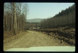
Aperçu avant impression Fermer

Affichage de 432 résultats

Archival description
352 résultats avec objets numériques Afficher les résultats avec des objets numériques
Britannia Mine Entrance?
2012.13.1.54.52 · Pièce · July 1980
Fait partie de J. Kent Sedgwick fonds

Image depicts the entrance to a mine with an unknown individual present. It is possibly the entrance to the closed Britannia Mine in the Howe Sound Region.

Cariboo Road
2012.13.1.6.029 · Pièce · May 1974
Fait partie de J. Kent Sedgwick fonds

Image depicts the old, grown-over Cariboo Road at an uncertain location.

BCR
2012.13.1.50.027 · Pièce · 1975
Fait partie de J. Kent Sedgwick fonds

Image depicts the BCR tracks passing through a mill somewhere near the 100 Mile.

Stewart Access Road - Warning Sign
2012.13.1.51.037 · Pièce · May 1973
Fait partie de J. Kent Sedgwick fonds

Image depicts an unknown individual leaning against a sign at the Stewart Access Road which warns travellers to pack several days of food. Located in Hazelton, B.C.

Snowy Road and Houses
2012.13.1.87.011 · Pièce · [between 1975 and 1995]
Fait partie de J. Kent Sedgwick fonds

Image depicts a snow-covered road with vehicle tracks, and several houses. The location is uncertain.

Boat on a Lake
2012.13.1.87.034 · Pièce · [between 1975 and 1995]
Fait partie de J. Kent Sedgwick fonds

Image depicts a riverboat on the Fraser River, possibly in Longworth, B.C.

Snowy Road
2012.13.1.87.039 · Pièce · [between 1975 and 1995]
Fait partie de J. Kent Sedgwick fonds

Image depicts a road covered in snow running through the woods at an uncertain location.

Giscome Street Scene
2012.13.1.87.173 · Pièce · [between 1975 and 1995]
Fait partie de J. Kent Sedgwick fonds

Image depicts a street in Giscome B.C. The Giscome Store is located on the left side of the image with the church in the background. Map coordinates 54°04'18.5"N 122°21'57.7"W

A Bridge
2012.13.1.91.30 · Pièce · Oct. 1978
Fait partie de J. Kent Sedgwick fonds

Image depicts a truck on a bridge, possibly crossing over the Peace River.

Parking Lot Frisbee
2012.13.1.93.18 · Pièce · 1979
Fait partie de J. Kent Sedgwick fonds

Image depicts a group of people throwing a frisbee in a parking lot at an uncertain location, likely in the Peace River Region.

Group and a Bus
2012.13.1.93.34 · Pièce · 1978
Fait partie de J. Kent Sedgwick fonds

Image depicts a group of individuals and a bus with words that read: "Prince George Limousine & Charter." The river in the background is possibly the Peace River, and the location is possibly somewhere near Fort St. John, B.C.

Paddlewheel Park
2012.13.1.7.202 · Pièce · Nov. 2000
Fait partie de J. Kent Sedgwick fonds

Image depicts the Fraser River at Paddlewheel park, with a train on the other side of the river, in Prince George B.C.

Highway 97
2012.13.1.7.224 · Pièce · May 2001
Fait partie de J. Kent Sedgwick fonds

Image depicts a view along Highway 97 in Prince George, B.C.

GTP Roundhouse
2012.13.1.19.06 · Pièce · 1979
Fait partie de J. Kent Sedgwick fonds

Image depicts the Grand Trunk Pacific railway roundhouse in Prince George, B.C.