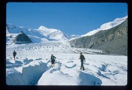
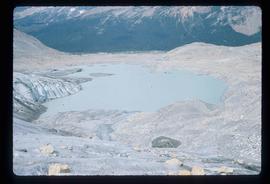
Image depicts a group of people standing on the foot of a glacier, possibly the Robson Glacier.
Image depicts a group of people hiking on a glacier, possibly the Robson Glacier.
Image depicts a group of people hiking up a mountain side, possibly Mt. Robson.
Image depicts a group of hikers standing on a slope.
Image depicts a climbing either up or down a rock face.
Image depicts a view of Mt. Robson Provincial Park.
Image depicts a group of individuals at camp somewhere in Mt. Robson Provincial Park.
Image depicts Kent Sedgwick with a dog at his feet, somewhere in Mt. Robson Provincial Park.
Image depicts a glacier somewhere in Mt. Robson Provincial Park.
Image depicts a group of people standing near a river. A glacier is visible in the background.
Image depicts four unknown individuals studying a plant.
Image depicts a small lake somewhere in Mt. Robson Provincial Park.
Image depicts the hiking group. Kent Sedgwick is located in the back row, third from the left with a pipe.
Image depicts the McLeod River in Carp Lake Provincial Park.
Image depicts War Lake.
Image depicts a view of Prince George from the cutbanks.
Image depicts a few old buildings, as well as several unknown individuals somewhere in Moricetown, B.C.
Image depicts a beaver dam somewhere in Hazleton, B.C.
Image depicts a cutbank on the Nechako River in Prince George, B.C.
Image depicts the Fraser River from the vantage point of the cutbanks in Prince George, B.C.
Image depicts a view of Prince George from the cutbanks on the Nechako river.
Image depicts a section of forest in the Bulkley Valley.
Image depicts the Bulkley River near Moricetown, B.C.
Image depicts part of the McMillan Creek Trail in the McMillan Regional Park in Prince George, B.C.
Image depicts part of the McMillan Regional Park in Prince George, B.C.
Image depicts the McMillan Creek from Northwood Pulpmill Road, in Prince George, B.C.
Image depicts a farmhouse on Old Summit Road in Prince George, B.C.
Image depicts an esker at Bednesti Lake, B.C.
Image depicts a crevasse filling ridge somewhere in the Bulkley Valley, B.C.
Image depicts a barn with large, Harvestore Systems. It is possibly located on one of the many farms near Vanderhoof, B.C.
Image depicts numerous unknown individuals searching through a fossil bed, possibly in the Bulkley Valley.
Image depicts a fossil bed, possibly somewhere in the Bulkley Valley.
Image depicts an individual opening the gate at Nautley in Fort Fraser, B.C.
Image depicts a view of the Fraser-Nechako confluence from the Prince George cutbanks.
Image depicts Burns Lake, B.C.
Image depicts numerous unknown individuals standing by the Bulkley River near Moricetown, B.C.
Image depicts a group of people in the historical village of 'Ksan near Hazelton, B.C.
Image depicts a group of people at a mine somewhere near Hazelton, B.C.
Image depicts a group of unidentified individuals walking along a crevasse filled ridge somewhere in the vicinity of Smithers, B.C. The slide also labels it as a "drift ridge."
Image depicts the slopes of Tabor Mountain in Prince George, B.C.
Image depicts the Fraser River in the Lillooet, B.C.
Image depicts the canoe group portaging to Indianpoint Lake.
Image depicts Indianpoint Lake.
Image depicts the foot of Indianpoint Lake.
Image depicts the sunset over Isaac Lake from the Betty Wendle campsite.
Image depicts a camp at the foot of Isaac Lake.
Image depicts the Cariboo Falls.
Image depicts the lower end of the river channel leading to the Spectacle Lakes.
Image depicts a few unknown individuals canoeing in a slough area while on approach to Bowron Lake.
Image depicts a slough area while on approach to Bowron Lake.