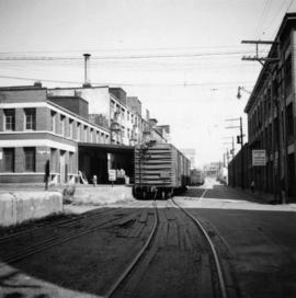
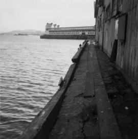
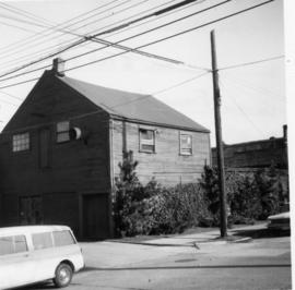
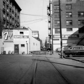
Showing 498 results

Archival description
2013.6.36.1.002.057 · Item · Aug. 1965
Part of David Davies Railway Collection

Photograph depicts a former C.P.R. connection between the False Creek yards and the south side of Vancouver harbour on West Pender St. in Vancouver, B.C. This spur used daily to get cars into the B.C. Electric Rail yard at the Georgia Viaduct from the C.P.R. False Creek yards.

2013.6.36.1.002.090 · Item · Mar. 1966
Part of David Davies Railway Collection

Photograph depicts the seaward end of C.P.R. pier A1 (now 12A), showing its rotted condition. The pier was built in 1890 and is still in use except at this outer face. C.P.R. pier B1 is in the background.

2013.6.36.1.002.106 · Item · Apr. 1966
Part of David Davies Railway Collection

Photograph depicts the junction of Robson and Cordero St. in west end Vancouver, B.C. The photo is looking northwest on the newly demolished block, except for some houses at far end. View is looking down Robson St., with Cordero St. intersecting the photo.

Track shed along CPR line
2013.6.36.1.027.01 · Item · [23 June 1979]
Part of David Davies Railway Collection

Photograph depicts a track shed about 1 mile south of Beaverdell or at about mile 43.25 on the CPR line in the Carmi Subdivision. Despite the open doors and ease of access, it was the only hut on the line found to contain track materials and correspondence. It retained 50 memos addressed to the Section Foreman [at Beaverdell?].

Westbridge CPR depot
2013.6.36.1.027.14 · Item · [July 1966]
Part of David Davies Railway Collection

Photograph depicts the Westbridge CPR depot on the Kettle Valley Line. It is located about 11 miles north of Rock Creek and at about mile 123.3 east of Penticton. The depot house is disused and the sidings contained no cars, so there appears to be no local traffic.

Grain elevator at Wynndel
2013.6.36.1.028.05 · Item · Aug. 1983
Part of David Davies Railway Collection

Photograph depicts the a grain elevator at Wynndel, located at mile 73.8 on the CPR line on the Nelson Subdivision. It is between Creston at mile 67.2 and Kootenay Landing at mile 83.1. Grain elevators are rare in BC and this one belongs to the United Grain Growers. The view is looking east.

CPR depot at Proctor, BC
2013.6.36.1.028.43 · Item · 16 Sept. 1970
Part of David Davies Railway Collection

Photograph depicts the CPR depot at Proctor, located at mile 117.5 from Cranbrook on the Nelson Subdivision. David Davies notes: "The view is looking east and shows the spur at right leading to a barge slip on Kootenay Lake. The majority of the spur rails here are dated 1908-1910." An updated description provided by a subject expert suggests that this view is actually looking west.

Abandoned house, Trout Lake
2013.6.36.1.072.03 · Item · 6 Sept. 1970
Part of David Davies Railway Collection

Photograph depicts an abandoned house in a semi-host town viallage that dated back to 1895-1900. It was coverd with hop flowers which was typical for most of the deserted homes in the area. Village had 20 buildings standings of which 12 were occupied.

2013.6.36.1.072.06 · Item · [July 1969]
Part of David Davies Railway Collection

Photograph depicts the Moha "ghost" vilage, 20 miles west of Lillooet, at the fork of Bridge and Yalako Rivers. It used to be a gold mining village. About 8 houses/cabins were left standing, but none were occupied. Displayed is one that had 2 ft. thick walss to waist height, as shown.

2013.6.36.1.076.08 · Item · 9 Oct. 1971
Part of David Davies Railway Collection

Photograph depicts a general store owned by Acton Kilby that was still operated by him at age 81. His family had moved from New Westminster in 1902 to run the store. The CPR depot originally connected direcly to the second floor of the building. Harrison Mills lay at the junction of the Harrison and Fraser Rivers and was an important site during steamboat days. Now it was a backwater of 3 dwellings beside the railway.

2013.6.36.1.077.06 · Item · 16 Sept. 1970
Part of David Davies Railway Collection

Photograph depicts the Transformer Sub-Station of West Kootenay Power and Light Company, which is the only private power distribution company left in B.C. at the time. In was built in 1905 and was in operation by 1906. There were identical buildings made in Grand Forks and Phoenix, but they were demolished at the latter place.

CPR wharf building
2013.6.36.1.077.08 · Item · [22 July 1968]
Part of David Davies Railway Collection

Photograph depicts a CPR wharf building at Okanagan Landing, Okanagan Lake. It was presumably used as a covered slipway and as a store. It was was now boarded up and the rail track between Vernon and Okanagan Landing was removed in 1940.

Glenwalker Ranch
2013.6.36.1.078.01 · Item · [13 May 1979]
Part of David Davies Railway Collection

Photograph depicts Glenwalker Ranch. Visible are details of the log construction of a barn that was built between 1890 and 1910.

O'Keefe Ranch
2013.6.36.1.078.03 · Item · [July 1966]
Part of David Davies Railway Collection

Photograph taken at Okangan Lake, on Alexis Beach. O'Keefe Ranch is located at the head of the lake. Visible is an old house that was used as a hay barn.

2013.6.36.1.079.05 · Item · [9 Sept. 1970]
Part of David Davies Railway Collection

Photograph depicts a working undershot water wheel on Lardeau Creek River. It was the only water wheel seen in B.C. between 1963 and 1970. It was designed to drive an electricity generating set, but it was not coupelled to the set at the time.