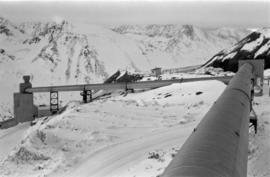
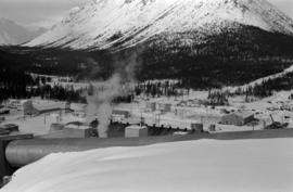
Photograph depicts tramline conveyor (located west of mine). Conveyor ran from crusher plant to tramline loading station. Mine valley and northwestern mountain range in background.
Mill building in left midground. Conveyor believed to be leading to tailings pile can be seen in foreground. Valley and mountains in background.
Plant buildings stand in midground. Conveyor believed to be leading to tailings pile can be seen in foreground. Valley and mountains in background.
- File contains photographs done to item level description, depicting miscellaneous people and locations at or around Cassiar, B.C. This includes a photograph of renowned prospector William (“Bill”) Storie, Bill Pratt with a fox, a community gathering in a someone's home, and a hockey game.
- Also included but not to item level is a photo of "David Madore" as part of his application to Cassiar, photo of "William Field" a local hire maintenance mechanic, and photos of a RNWMP Post sign (Royal North West Mounted Police) that depicts annotations "Indian grave" , "Miners Cabin" , "Road House" , "Customs House" , "St. James Church" , "Swansons Store" etc., and 15 negatives of various individuals at what appears to be someone's home.
- Also included is cabin at Boya Lake, which used to be named Chain lake, located off the Stewart-Cassiar highway. This land of this cabin may have been involved legal issues , which was related to people at Cassiar.
Photograph depicts William (Bill) Storie at location known as Limestone Mountain, southwest of Cassiar, B.C. Photo features profile of Bill, hands in pocket, Cassiar valley and mountains in background. Storie was a renowned prospector in the Cassiar area, and the new school at Cassiar was named for him in 1992.
Photograph depicts wood houses behind stand of trees in Cassiar valley. Truck, power poles, and road in foreground, mountains in background. Typed caption below photo in original duotang album: "Two Bedroom Pan-Abode Houses - Cassiar Townsite". Handwritten annotation on verso: "Sept 1954".
Photograph depicts snow-plowed road in foreground, Cassiar mountians in background. Road is lined with trees and power poles, and vehicle is visible in distance. Handwritten annotation on recto of photograph: "Looking west from townsite".
Photograph depicts unidentified individual and cars on street in foreground, snow banks, trees, and power poles on either side. Buildings can be seen on far right, mountains visible in background. Handwritten annotation on recto of photograph: "townsite Looking East".
File contains photographs depicting four different tours that took place at the mine, plant, and towns owned by Cassiar Asbestos Corporation Ltd. Tours include Prime Minister Pierre Trudeau's visit to Clinton Creek in 1968 and Member of Parliament Iona Campagnolo's visit to Cassiar in 1978. Photographs also depict a party of ambassadors touring Cassiar in 1970, and the dedication of a building in the Cassiar plant in the late 1970s.
Photograph depicts group of eight men standing in line in the Cassiar valley. Left to right: Charles Rainforth Elliot, John Drybrough, John E. Kennedy, Fred Martin Connell, W. Harold Connell, Ken A. Creery, George Washington Smith, Tam Zimmermann. Power lines and mountains in background.
Photograph depicts group of eleven men standing in line in the Cassiar valley. Left to right: Jack Christian, Charles Rainforth Elliot, John Drybrough, John E. Kennedy, Fred Martin Connell, W. Harold Connell, Ken A. Creery, George Washington Smith, Tam Zimmermann, [Fred Murray]?, Nick Gritzuk. Power lines and mountains in background. Most men featured in photo are believed to be members of Cassiar's Board of Directors. Photograph was originally framed with note "Summer 1961" written on cardboard backing.
Photograph depicts group of eleven men standing in line in the Cassiar valley. Left to right: Jack Christian, Charles Rainforth Elliot, John Drybrough, John E. Kennedy, Fred Martin Connell, W. Harold Connell, Ken A. Creery, George Washington Smith, Tam Zimmermann, [Fred Murray]?, Nick Gritzuk. Creery looks through his own camera, appearing to photograph the photographer. Power lines and mountains in background. Most men featured in photo are believed to be members of Cassiar's Board of Directors.
The topographic map shows mine and campsite holdings within the proposed mine site. Asbestos deposits, the tramline and water bodies, such as Troutline Creek, are also included.
Annotations include certain lot titles being crossed out as well as as indication of missing survey information.
Overview of a snow covered mountain tops of the Cassiar Mountains. Handwritten annotation on verso in pen reads: “Cassiar mtns.”
View of snow capped mountains in the distance, vast rolling treed hills in mid ground and a gravel road in the foreground. Road sign indicating severe curve in road situated at the right of the gravel road. Handwritten annotation on verso in pen reads: “Cassiar – Stewart highway”
View of snow capped mountains in the distance, trees and river in mid ground. A Jeep type vehicle is on a bridge in the mid ground with river and sandbar in the foreground. Handwritten annotation on verso in pen reads: “Cassiar Road. Cottonwood River crossing”
Photocopied map depicts mineral and coal mining properties in north western British Columbia.