Aperçu avant impression Fermer

Affichage de 581 résultats

Archival description
482 résultats avec objets numériques Afficher les résultats avec des objets numériques
Downtown Prince George Businesses
2012.13.1.3.108 · Pièce · 12 Oct. 1989
Fait partie de J. Kent Sedgwick fonds

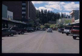
Image depicts 4th Ave at Quebec St, showing the following businesses: The Yarn Barn, Golden Chalice Jewellers, Dandy Lines, Ultrasport, and Saveco. Map coordinates 53°54'58.6"N 122°44'47.5"W

2012.13.1.3.110 · Pièce · 12 Oct. 1989
Fait partie de J. Kent Sedgwick fonds

Image depicts George St in downtown Prince George with City Hall in the background. Also visible are the Prince George Hotel, Ming's Inn Chinese Restaurant, Fraser Stationers Ltd., Weiner King food cart, and a movie theatre. Map coordinates 53°54'55.0"N 122°44'36.1"W

East Line
2012.13.2.17 · Sous-série organique · 1972-2011
Fait partie de J. Kent Sedgwick fonds

Subseries consists of material collected by Kent Sedgwick for research regarding the communities along the East Line of the Grand Trunk Pacific Railway in Central British Columbia, particularly between Prince George and McBride. These communities and locations include, among others, Shelley, Willow River, Sinclair Mills, Longworth, Dunster, Tete Jaune, Valemount, Mount Robson, and the Yellowhead Pass. Research on these communities was conducted during Kent Sedgwick's involvement in the UNBC-led Upper Fraser Historical Geography Project. The files primarily consist of research notes, audio and transcripts of oral interviews, and photographs of the East Line communities.

Eskers Park
2012.13.1.3.138 · Pièce · 16 June 1992
Fait partie de J. Kent Sedgwick fonds

Image depicts Eskers Park, near Prince George, B.C.

Europe Hotel
2012.13.1.7.178 · Pièce · Dec. 1999
Fait partie de J. Kent Sedgwick fonds

Image depicts the Europe Hotel in Prince George prior to its demolition in the 1980s; however, the slide itself was only made in 1999 and the date of the photo is otherwise unknown, but most likely around 1979.

Europe Hotel on 3rd Avenue
2012.13.1.135.01.22 · Pièce · [between 1980 and 2000]
Fait partie de J. Kent Sedgwick fonds

Photograph depicts the Europe Hotel on the South side of 3rd Avenue. Annotation on verso: "Europe Hotel".

Exhibition Sports Centre
2012.13.1.7.234 · Pièce · Mar. 2003
Fait partie de J. Kent Sedgwick fonds

Image depicts the Exhibition Sports Centre, which used to be a drill hall army base, on Keller Street in Prince George, B.C.

Exhibition Sports Centre
2012.13.1.7.244 · Pièce · Mar. 2003
Fait partie de J. Kent Sedgwick fonds

Image depicts the Exhibition Sports Centre, which used to be a drill hall army base, on Keller Street in Prince George, B.C.

Experimental Farm
2012.13.1.3.129 · Pièce · 13 Aug. 1989
Fait partie de J. Kent Sedgwick fonds

Image depicts a view of an experimental farm, possibly taken from Tabor Mountain.

Farmhouse
2012.13.1.3.012 · Pièce · Apr. 1972
Fait partie de J. Kent Sedgwick fonds

Image depicts a farmhouse on Old Summit Road in Prince George, B.C.

Fifth Avenue Intersection
2012.13.1.3.162 · Pièce · May 2001
Fait partie de J. Kent Sedgwick fonds

Image depicts the intersection of 5th Ave and Highway 97 looking northeast. Map coordinates 53°55'14.0"N 122°46'54.8"W

Fifth Avenue Intersection
2012.13.1.3.163 · Pièce · May 2001
Fait partie de J. Kent Sedgwick fonds

Image depicts the intersection of 5th Ave and Highway 97 looking northeast. Map coordinates 53°55'14.0"N 122°46'54.8"W

Finish Line
2012.13.1.129.01 · Pièce · 1971
Fait partie de J. Kent Sedgwick fonds

Image depicts numerous skiers standing near a finish line somewhere on Tabor Mountain in Prince George, B.C.

Fire Place and Couch Snow Sculptures
2012.13.1.3.149 · Pièce · Apr. 1999
Fait partie de J. Kent Sedgwick fonds

Image depicts a snow sculpted fire place and couch on a skating rink, possibly during the Winter City Conference, in Prince George, B.C. Taken at the Prince George Civic Center. Map coordinates 53°54'45.6"N 122°44'59.6"W

Fishing
2012.13.1.23.15 · Pièce · 1973
Fait partie de J. Kent Sedgwick fonds

Image depicts two youths fishing from the bank of the Nechako River on Cottonwood Island.

Foothills Bridge
2012.13.1.3.123 · Pièce · 12 Oct. 1989
Fait partie de J. Kent Sedgwick fonds

Image depicts the Foothills Bridge over the Nechako river on the Foothills Boulevard in Prince George, B.C. Map coordinates 53°56'52.5"N 122°48'59.9"W

Forest for the World Plantation
2012.13.1.133.04 · Pièce · 1985
Fait partie de J. Kent Sedgwick fonds

Image depicts a group of trees in the Cottonwood Park, with a sign which reads: "This is the primary plantation for the 'Forest for the World' project. These trees were planted on August 5, 1985, commemorating Prince George's 70th birthday by the citizens of Prince George & Expo 86'."

Forestry Heavy Machinery
2012.13.1.122.29 · Pièce · May 1980
Fait partie de J. Kent Sedgwick fonds

Image depicts several pieces of heavy machinery used in forestry. The Coast Inn of the North is seen in the background.

Forestry Heavy Machinery
2012.13.1.122.30 · Pièce · May 1980
Fait partie de J. Kent Sedgwick fonds

Image depicts several pieces of heavy machinery used in forestry. The Coast Inn of the North is seen in the background.

Forestry Heavy Machinery
2012.13.1.122.28 · Pièce · May 1980
Fait partie de J. Kent Sedgwick fonds

Image depicts an unidentified individual examining a piece of heavy machinery used in the forestry industry. It is located in Prince George, B.C.

Fort George Park
2012.13.1.3.073 · Pièce · Oct. 1983
Fait partie de J. Kent Sedgwick fonds

Image depicts the Fort George Park. Map coordinates 53°54'30.2"N 122°43'57.4"W

Fort George Park
2012.13.1.3.113 · Pièce · 12 Oct. 1989
Fait partie de J. Kent Sedgwick fonds

Image depicts the Fort George Par, which was renamed Lheidli T'enneh Memorial Park in 2015. Map coordinates 53°54'30.2"N 122°43'57.4"W

Fort George Regional Museum
2012.13.1.3.071 · Pièce · Oct. 1983
Fait partie de J. Kent Sedgwick fonds

Image depicts the Fort George Regional Museum (now known as The Exploration Place) in Prince George, B.C. Map coordinates 53°54'18.6"N 122°44'09.8"W

Fraser River
2012.13.1.3.002 · Pièce · Oct. 1970
Fait partie de J. Kent Sedgwick fonds

Image depicts the Fraser River from Northwood Road in the Prince George area.

From Cutbanks
2012.13.1.3.005 · Pièce · Apr. 1972
Fait partie de J. Kent Sedgwick fonds

Image depicts the Fraser River from the vantage point of the cutbanks in Prince George, B.C.

Geography and Natural Resources
2012.13.2.11 · Sous-série organique · 1937-2011
Fait partie de J. Kent Sedgwick fonds

Subseries consists of materials collected by Kent Sedgwick for research on the geography and natural resources in Prince George and its region. Includes material on the natural resource industry, including the opening of the McArthur Sawmill, the W. Lamb and Sons Lumber Sawmill, and mining; photocopied aerial photographs of Prince George; the climate, temperatures, and flooding; and the geographical features of Prince George.

George Street
2012.13.1.7.220 · Pièce · May 2001
Fait partie de J. Kent Sedgwick fonds

Image depicts a view of George Street with the Prince George City Hall at the corner of George Street and 7th Avenue.

Ginter House
2012.13.1.014 · Sous-série organique · 1997
Fait partie de J. Kent Sedgwick fonds

File contains slides depicting images of the Ginter House from 1997 in Prince George, B.C.