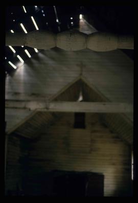
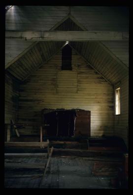
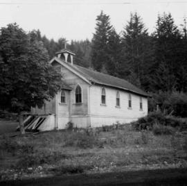
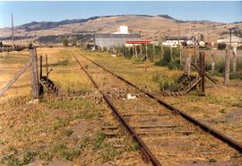
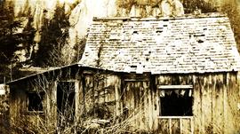
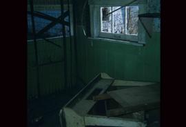
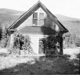
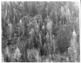
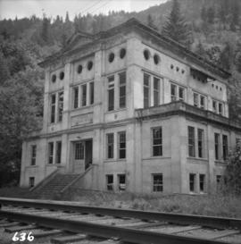
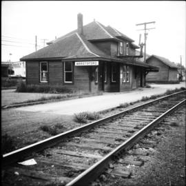
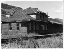
Photograph depicts abandoned Canadian Railroad Station Natal BC
Prince George Railway & Forestry Museum SocietyImage depicts an old and abandoned, collapsing church at an uncertain location.
Image depicts the interior of an old, abandoned church at an uncertain location; possibly somewhere between Lillooet and Kamloops.
Photograph depicts an abandoned church at Extension, B.C., west of Nanaimo.
Photograph depicts an abandoned coal mine in Coal Creek, 5 miles east of Fernie, BCThe entrance to the mine is unusual and is 2/3rds up the mountainside. The mine was closed in 1959. Flat ground in foreground is littered with at least 100 mine tubs of approximately 3'0' gauge.
Front view of an abandoned log building. The door is open or missing, the front window glass is broken, the area in front of the building is littered with antlers, boxes and wood. The tree next to the building has grown too close the building and roof. Handwritten annotation on verso in pen reads: “Laketon, Dease Lake, BC. Court house & jail June ‘62”
Photograph depicts an abandoned CPR grade near Christina Lake. Rockwork was built in 1898 which was quite rare.
Photograph depicts what was once part of Nicola branch. It was later truncated to a spur for oil tanks. At the time the photograph was taken, it was abandoned altogether.
Image depicts an old and abandoned duplex somewhere in Wells, B.C.
Photograph depicts two abandoned fishboats.
Photograph depicts a small abandon home. Handwritten annotation below photograph reads, "domicile of Mr. Roundy, Echo Cove".
Image depicts the interior of a house that appears to be abandoned and in disrepair in Island Cache.
The item is a photograph depicting an old, abandoned wooden house and barn on Holzworth homestead in the Fort George Canyon.
The item is a photograph depicting an old, abandoned wooden house on Holzworth homestead in the Fort George Canyon.
The item is a photograph depicting an old, abandoned wooden house on the Holzworth homestead in the Fort George Canyon.
Photograph depicts an abandoned house in a semi-host town viallage that dated back to 1895-1900. It was coverd with hop flowers which was typical for most of the deserted homes in the area. Village had 20 buildings standings of which 12 were occupied.
Photograph depicts an abandoned railroad grade. Handwritten annotation on verso reads: " Abandoned K & S RR grade"
Photograph depicts an abandoned log cabin in the Kettle Valley between Rock Creek and Westbridge, on the east side of the road approximately 5 miles from Rock Creek.
Photograph depicts an abandoned ranch house, southeast of Rock Creek, north of an abandoned GNR grade, and about a mile north of an international boundary.
Photograph depicts an abandoned settlement.
Photograph depicts the an abandoned steel trestle with the mid span missing about 15 miles northeast of Hope. It was part of the former CPR Coquihalla to Brookmere rail line.
Photograph depicts the abandoned Sumas substation at Vedder Mountain.
Photograph depicts Abandoned trailers.
Photograph depicts Abandoned trucks.
Photograph depicts an abandoned water tower. Handwritten annotation on verso reads: "Brookmere, BC"
Photograph depicts a wood fired case traction engine that was built in 1913. Displayed at the Abbotsford Agricultural Show.
Photograph depicts the Abbotsford CPR depot. It was built circa 1910-1914 and was the second depot built by the CPR in the town. It is at mile 6.7 on the the Huntingdon branch from Mission City. It was last used for passenger traffic in October 1959. It is No.5 standard design CPR depot.
Map depicts the Abbotsford area, including railway lines.
Wales, Great Britain
Caption describing photograph: "Excellent Abies second growth. 6-8 DBH. Age 40 years. Resulting from advanced regeneration after logging. Mile 5.5 Hart Highway. Average current leader 10". Silty clay, lacustrine deposits."
Caption describing photograph: "Typical crown form of Abies lasiocarpa, long barrow columnar crown. Ht 65', 10" DBH. Age 80 years. Mile 5 Hart Highway. Abies stand resulting from advanced regeneration released by logging of spruce in 1940s. Sandy silt lacustrine deposits."
File consists of a reprint from Regulated Rivers: Research and Management (vol. 3) by Shirvell entitled "Ability of PHABSIM to Predict Chinook Salmon Spawning Habitat".
File consists of catalogue records and excerpts from articles about Aboriginal painting, weaving, carving, knitting and other arts.
File consists of research materials consisting of printed webpages concerning Australian indigenous gardens and botany.
File consists of research materials on Australia, including book lists, catalogue records, and printed webpages.
Collection consists of eight interviews with experts reviewing A Guidebook for Improving Aboriginal Participation in Forest Management Decision-Making, later published with the title The Aboriginal Forest Planning Process: A Guidebook for Identifying Community-Level Criteria and Indicators by Melanie Karjala, Erin Sherry, and Stephen Dewhurst in 2003. The reviewers were chosen based on their expertise and interest in Aboriginal participation in forest management decision-making. They were asked to provide their opinions on issues related to Aboriginal participation in decision-making processes in BC, as well as feedback on the Aboriginal Forest Planning Process (AFPP) Guidebook. Reviewers had the option to make their review confidential resulting in the return or destruction of the interview. Eight of the original twenty-nine interviews are archived in this collection; the remainder are no longer extant.
The Aboriginal Forest Planning Process: A Guidebook for Identifying Community-Level Criteria and Indicators can be found:
- Online at www.for.gov.bc.ca/hfd/library/documents/bib95274.pdf
- UNBC Library, call number: SD146.B8 K37 2003.
Videotape contains footage of: 22-May-04 - Aboriginal Health Sciences program - field course near Nautley Reserve Tape 2 - George, Rita (hat); Thomas, Doris (orange); Louis, Kimberley (right); Louis, Cary-Anne (left); Palmantier, Monty
File consists of a letter re: 1998 Order of British Columbia Recipients from Dagmar Beiman, Coordinator Honours and Awards Secretariat to Bridget Moran (May 11, 1998), a letter from Daniel Birkenbach to Bridget Moran re: a paper he wrote (Aug. 2, 1996), and a copy of paper written by Daniel Birkenbach: "Canada - Life and Development of the Canadian Indians (past and present)."
File consists of a paper entitled "Aboriginal Land Claims In The Canadian North: The Battle For Rights".
File consists of excerpts regarding Aboriginal Land Rights.
File consists of a copy of a discussion paper from the Carrier Sekani Tribal Council entitled "Aboriginal Studies in a New Northern University" by Doug Brown.
File consists of About UNBC 2008.
File consists of About UNBC Guide & Statistics 2006.
File consists of About UNBC Guide & Statistics 2007.
Twin Falls Territorial Park, Hay River, Northwest Territories