File consists of clipping, notes, and reproductions relating to the Natural Resources Security Company, the company was responsible for a land-selling campaign, selling lots for the townsite to later be Central Fort George, which was owned and ran by George John Hammond in Fort George. Includes: "The sales campaign of George J. Hammond and the Natural Resources Security Company" typescript research essay by Anna Bumby (30 Apr. 1981); "Fort George and its tributary territory" photocopied article from British Columbia Magazine (1912); "Facts, what British Columbia offers you" reproduction of a pamphlet produced by the Natural Resources Security Company, Ltd. (1910); and reproduced excerpts from an unidentified pamphlet issued in 1912 by the Natural Resources Security Company, Ltd.
File consists of the "McGregor Model Forest Association: Annual Report 2005-2006."
File consists of the "Operational-Scale Carbon Budget Model of the Canadian Forest Sector (CBM-CFS3) Version 1.0: User's Guide" created by the Canadian Forest Service Northern Forestry Centre.
File consists of Russian language Canadian Council of Forest Ministers Pamphlets.
File consists of notes and reproductions relating to the British Columbia Historical Federation 2006 Annual Conference in Kimberley. Includes: "Kimberley Historic Calendar" prepared by the Kimberley Heritage Museum (2005).
File consists of correspondence to and from the Aleza Lake Research Forest regarding various issues.
File consists of notebook filled with tree data from different sites.
File consists of notes, clippings, and reproductions relating to the Cariboo and Northwest Digest publication. Also includes a CD-R that contains Sedgwick's index spreadsheet and accompanying documentation about the publication.
File contains:
- B.C. Forest Service, "Site Index: A Growing Issue" pamphlet, 1986
- The Working Forest Project, "Clearcuts don't stay cleared... End of argument." pamphlet, 1994
- Forest Engineering Research Institute of Canada, "Handbook for Ground Skidding and Road Building in the Kootenay Area of British Columbia", 1976
- Canadian Pulp and Paper Association, "From Watershed to Watermark: The pulp and paper industry of Canada", 1987
- Forest Productivity Councils of British Columbia, "Forest Growth and Yield in British Columbia - Vision" pamphlet
- Prepared for BC Ministry of Forests and Range by Laszlo Orbay and Derek Goudie or Forintek Canada Corp., "Values and Volumes of Lumber Recovered from Mountain Pine Beetle Killed Wood", 2006
File consists of a media release regarding the New Russian Project and a document "McGregor Model Forest Association: Russian Project."
File consists of a number of issues from the McGregor Model Forest Network: Advances Newsletter ranging from 1994 to 2005 regarding model forest projects. File contains the following issues: October 1994, July 1995, Third Quarter 1996, Spring 2000 and December 2005. File also includes an information sheet titled "McGregor Model Forest-Backgrounder" and a page from the Canadian Model Forest Network titled "The McGregor Approach to Sustainable Forest Management."
File consists of proceedings and abstracts for conferences and workshops attended by Paul Sanborn.
Includes the following items:
Alloway, B.V., D.G. Froese, and J.A. Westgate (eds.) 2005. Proceedings of the International Field Conference and Workshop on Tephrochronology & Volcanism: Dawson City, Yukon Territory, Canada, July 31st – August 8th, 2005.
BC Forestry Continuing Studies Network. 1994. Workshop proceedings: Grasses and legumes in forestry - A forum for discussing the economic and ecological costs and benefits of using grass and legume species in all phases of northern forest management. Prince George, BC: April 6-7, 1994.
Canadian Quaternary Association. 2001. Canadian Quaternary Association Meetings, 2001: Program and Abstracts. Occasional Paper in Earth Sciences No. 1. Heritage Branch, Government of the Yukon. http://emrlibrary.gov.yk.ca/Tourism/canadian-quaternary-association-meetings-program-and-abstracts-2001.pdf
Enhanced Forest Management Pilot Project. 2000. Proceedings of the March 30-31 Information Session. Robson Valley Forest District. [9 extended abstracts & full articles]
Society for Ecological Restoration. 1995. Taking a broader view: 1995 international conference. September 14-16, 1995. University of Washington, Seattle WA, USA. [program & abstracts]
File contains photographs of The Pas Lumber Company Ltd. Includes other northern BC forestry industry images, including Number 5 Timber Ltd. CP625 Block 101, bridge construction, and heavy machinery. Also includes a graphic postcard of Prince George circa 1970s.
File contains newspaper and periodical clippings collected by Bill Stowell over the course of his career in the BC forestry industry. Includes the following full issues:
- Canadian Sustainable Forestry Certification Coalition "Bulletin", Vol. 5, No. 2, August 1999
- Forest Alliance of British Columbia, "Choices: Issues and Options for B.C. Forests", Vol. 8, No. 1, [2000?]
- Crestbrook Forest Industries Ltd., "The Log", October 1981
- MacMillan Bloedel Limited, "MB Journal", Vol. 10, No. 6, June 1990
- "Forests Forever: Northern Interior" special B.C. forest industry newspaper supplement [to the Prince George Citizen], March 1989
File consists of "McGregor Model Forest: First Nation Youth Programs in the Natural Resource Sector of British Columbia" by Brandon W. Prince. Includes case studies of Adams Lake Indian Band (Sexqeltqi'n), Duke Energy: Gas Transmission, the Aboriginal Human Resources Development Strategy, Nicola Valley Institute of Technology - Natural Resources Technology Program, and UBC Summer Forestry Camp for First Nation Youth.
File consists of the February 21, 2005 draft of "to 2007 and Beyond: The Pathway to Sustainability of our Forests and the Communities within Them" approved by the McGregor Model Forest Association Board of Directors.
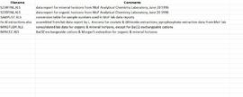
Data sets associated with the Arocena & Sanborn 1999 regional soil mineralogy study:
- S234FINL.XLS [data report for mineral horizons from MoF Analytical Chemistry Laboratory, June 20 1996]
- S235FINL.XLS [data report for organic horizons from MoF Analytical Chemistry Laboratory, June 20 1996]
- SAMPLIST.XLS [conversion table for sample numbers used in MoF lab data reports]
- Fe Al extractions.xlsx [assembled from lab data report by L. Arocena for oxalate & dithionite extractions; pyrophosphate extraction data from MoF lab]
- MINSTUDY.XLS [consolidated lab data for organic & mineral horizons, except for BaCl2 exchangeable cations]
- MINCEC.XLS [BaCl2 exchangeable cations & Morgan’s extraction for organic & mineral horizons]
File consists of records created and collected by Grant Hazelwood in connection to his work on the Stikine Country Protected Areas Advisory Committee and its Gladys Lake Sub-committee.
File consists of photographs of John Revel taken above the old Aleza Lake Forest Experiment Station site. John Revel was a retired pioneering BC Forest Service silviculture forester.
File consists of the "McGregor Model Forest Association: Annual Report 2004-2005."
File consists of printed power point slides for the "McGregor's Role Supporting Communities: NCMA Conference."
File contains a computer print-out of the Aleza Lake Research Forest Management Plan #2 for the years 2005 to 2010, which was prepared by Mike Jull and Melanie Karjala.
File consists of notes, clippings, and reproductions relating to historical and contemporary natural resource surveys in British Columbia. Includes material on oil discovery, farming conditions, timber stands, the Alaskan Highway, and railway development. File predominantly consists of search results from the University of Northern British Columbia library, College of New Caledonia library, and Prince George Public Library regarding British Columbia's natural resource surveying.
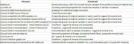
Data sets associated with the Cluculz retrospective study (E.P. 886.10):
- 082036.xls -- Elemental analysis (XRF) for mineral horizon samples from profile at Cluculz EP 886.10 site
- CLUCINC.xls -- Summary chemical properties for composite samples in aerobic incubation
- Cluculz Ck 2002 Foliar Analysis.xls -- Analyzed for individual single-tree plots
- Cluculz Ck 2002 Forest Floor.xls -- Forest floor mass data
- Cluculz composite list (2003 samples).xls -- Composite groups (3 original samples in each) used for organic & mineral soils
- Cluculz composite list (incubation experiment).xls -- Composite groups (3 original samples in each) used for organic & mineral soils
- Cluculz composite list for incubations (2003 samples).xls -- Composite groups (3 original samples in each) used for organic & mineral soils
- Cluculz Creek S mineralization - initial fractions (2).xls -- S fractions - organic & mineral soil composites
- Cluculz Creek S mineralization - initial S fractions.xls -- S fractions - organic & mineral soil composites
- Cluculz Creek S mineralization (IC).xls -- S mineralization data for aerobic incubation - organic & mineral soils
- Cluculz foliar and soil data.xls -- Chemical properties of foliage, composite forest floors, composite mineral soils
- Cluculz pH.xls -- pH - organic & mineral soil composites
- Cluculz S fraction graphs.xls -- S fractions - organic & mineral soil composites
- Elemental Analysis of Standard by XRF (2005).xls -- Published & XRF analysis of CANMET TILL-1 soil standard (used in Cluculz XRF analysis)
File consists of a number of MMFA Advances in Sustainable Forest Management newsletter issues ranging from 1995 to 2004 regarding model forest projects. Included issues: January 1995, April-June 1995, October 1995, First Quarter 1996, Second Quarter 1996, Fall 2000, Fall/Winter 2001, Fall 2002, Spring 2003, Fall 2003, and Spring 2004.
File consists of notes and reproductions relating to the Northern Dairies milk shipping company and William Binney Milner, a Vancouver-based financier who purchased Northern Dairies Ltd. In 1956.
File consists of submissions to the Aleza Lake Research Forest logo contest.
This file contains the following photographs in both print photograph and negative format:
Thorsen Bay
Print roll 11, #01-2A
Corresponding slides: slide roll 6, #12-10
Y04-19 (27.5 km on Cultus Bay Rd., near Thorsen Bay)
Date: July 22, 2004
Location Coordinates: 61º 12’ 3.0” N, 138º 28’ 58.3’ W, 819 m asl (± 18.9 m)
Site Description: Roadcut at base of 30º, E-facing slope. Colluviated loess overlies sandy glaciofluvial at 120 cm. Prominent paleosol with “cumulic” B horizon at 80-120 cm, with strong effervescence throughout exposure.
Print roll 11, #3A-5A (profile), #6A-10A (landscape)
Corresponding slides: slide roll 6, #9-7 (profile), #6-1 (landscape)
Sample Depths & Descriptions: Y04-19-01 – charcoal at 95 cm
Roadcut opposite ~ 30 m to NE on grassy S aspect (10° slope) with 15-20 cm of calcareous loess and sand over 2 cm White River ash; strongly effervescent throughout.
Print roll 11, #11A-12A (profile)
Corresponding slides: slide roll 7, #36-35 (profile)
Thorsen Bay landscape
Print roll 11, #13A-16A
Corresponding slides: Slide roll 7, #34-32
Y04-20B
Date: July 22, 2004
Location Coordinates: 61º 10’ 16.5” N, 138º 26’ 18.7’ W, 797.5 m asl (± 5.9 m)
Site Description: wind-eroded Slims soil on glaciolacustrine with contorted bedding (exposed on blown-out roadcut); calcareous to surface; White R ash pockets at 10-20 cm; S aspect, 5° slope.
Print roll 11, #17A-21A
Corresponding slides: Slide roll 7, #31-26
Y04-22
Date: July 22, 2004
Location Coordinates: 61º 9’ 39.24” N, 138º 25’ 7.8’ W, 790.6 m asl (± 6.4 m)
Site Description: toe of 30° slope, W aspect (grassy slope with poplar at toe); 1.0-1.2 of colluviated loess over gravelly glaciofluvial with buried soil at 70-80 cm
Print roll 11, #22A-24A
Corresponding slides: Slide roll 7, #25-24
File consists of a folding containing Model Forest Network and McGregor Model Forest Association introductory and summary documents for the years 2002-2004. File includes: McGregor Model Forest Annual Report 2002-2003, "The Canadian Model Forest Network," issue of "McGregor Model Forest Association Advances" for Spring 2004, and "A Sustaining Vision: Sustainable Forest Management in BC's Omineca Region." File also contains a bookmark advertising www.modelforest.net.
File consists of notes and reproductions relating to John Prince Myers, one of the founders of Cranbrook Sawmill, and his house at 1633 Norwood Street that burnt down in 1933. File primarily consists of photocopied newspaper articles relating to the Cranbrook Sawmill and the burning of the house at 1633 Norwood Street, and printed copies of photographs from The Exploration Place Museum database depicting the house and sawmill. Includes printed email chain between Greg Halseth, Kent Sedgwick, and John G . Myers (Sept. 2004).
File consists of notes and reproductions relating to the ownership and chronology of Giscome Farm Ltd., on District Lot 9937 Cariboo District in Giscome, British Columbia.
File consists of notes, clippings, and reproductions relating to the Giscome Farm Ltd. File also includes photographs depicting the Giscome Farm.
This file contains the following photographs in both print photograph and negative format:
Kluane Lake (S. shore, near Kluane Lake Research Station)
Print roll 10, # 34-36
File consists of the "McGregor Model Forest Association: Annual Report 2003-2004."
File consists of a CD-ROM containing three PDF documents: "Canada's Model Forest Program Publications Catalogue" September 2003, "Canada's Model Forest Program: Advancing Sustainable Forest Management from the Ground Up" c. 2003, "Canadian Model Forest Network Private Woodland Owners-Meeting the Stewardship Challenge" c. 2004. Documents exist in both French and English.
This file contains the following photographs in both print photograph and negative format:
Cultus Bay Rd.
(landscape views looking W from road; lake is likely at ~61°4’ 10.5”N, 138°22’ 31.5”)
Print roll 12, #0A-2A
Corresponding slides: Slide roll 7, #23-22
Keyhole Pond (landscape views)
Print roll 12, #3A-4A
Y04-23 (Saddle W of Keyhole Pond)
Date: July 22, 2004
Location Coordinates: 61º 4’ 46.5” N, 138º 22’ 32.2’ W, 828 m asl (± 8.0 m)
Site Description: 7º, NW-facing slope. Cumulic profile in colluviated loess with White River tephra at 10 cm, brownish paleosol at 23-27 cm, glaciofluvial sand at 50 cm.
Sample Depths & Descriptions: Y04-23-01 – charcoal at 23-27 cm, immediately above paleosol
Print roll 12, #5A-6A
(Location not recorded: Print roll 12, #7A-8A)
Y04-24 (W side of Rat Lake)
Date: July 22, 2004
Location Coordinates: 61º 9’ 54.6” N, 138º 25’ 41.6” W, 807.7 m asl (± 13.5 m)
Site Description: 23° slope, NE aspect; cumulic profile with White R ash at 20 cm; no obvious charcoal bands.
Print roll 12, #9A-10A (9A print is missing)
"Ian's Lake"(W of NW corner of Rat Lake)
Location Coordinates: 61º 10’ 1.4” N, 138º 25’ 47.7” W, 773.4 m asl (± 9.8 m) (coordinates are for ridge crest on NE side of lake)
Site Description: basal date 700 BP in terrestrial sediments; NE side has grassy 30°slope
Print roll 12, #11A
Y04-25 (S shore of “Ian’s Lake”, NW of Rat Lake)
Date: July 22, 2004
Location Coordinates: 61º 10’ 0.7” N, 138º 25’ 49.2” W, 781.8 m asl (± 8.8 m)
Site Description: 35 cm of colluviated loess over gravelly sandy glaciofluvial; no visible charcoal bands; buried soil at 25-35 cm; White R ash at 6-8 cm.
Print roll 12, #12A-13A
Y04-26 (EW)
Date: July 23, 2004
Location Coordinates: 61º 1’ 59.8” N, 138º 21’ 53.6” W, 836.1 m asl (± 7.7 m)
Site Description: grassland at crest of 33° terrace scarp, S aspect.
Sample Depths & Descriptions: Y04-26-01 – 0-10 cm
Print roll 12, #14A-15A
Corresponding slides: Slide roll 7, #21-20
Y04-27
Date: July 23, 2004
Location Coordinates: 61º 2’ 0.9” N, 138º 21’ 53.6” W, 843.6 m asl (± 5.8 m) (~ 35 m N of Y04-26)
Site Description: spruce forest on terrace surface; level.
- 0-8 cm - Loess-rich forest floor; strongly calcareous.
- 8-13 cm - Bmk
- 13-15 cm - Discontinuous pockets of White R ash
- 15-35 cm - Bmk (Slims soil) – no charcoal visible
- 35-75 cm - Gray calcareous loess.
- 75 cm+ - Gravelly sandy glaciofluvial deposit.
Print roll 12, #16A-17A
Corresponding slides: Slide roll 7, #19-18
Y04-28 (EW)
Date: July 23, 2004
Location Coordinates: 61º 2’ 34.4” N, 138º 21’ 57.0” W, 820.2 m asl (± 6.1 m)
Site Description: grassland on esker crest W of Jenny L; 30° slope, SW aspect
Sample Depths & Descriptions: Y04-28-01: 0-10 cm
Print roll 12, #18A-19A
Corresponding slides: Slide roll 7, #17-16
Y04-30 (between eskers, W of Jenny Lake)
Date: July 23, 2004
Location Coordinates: 61º 2’ 31.6” N, 138º 21’ 52.3’ W, 817.6 m asl (± 6.1 m)
Site Description: Level (base of saddle). Colluviated loess to 90 cm+, with White River tephra at 15-17 cm, brownish paleosol at 17-35 cm, underlain by turbated Bmku with multiple charcoal-rich bands.
Sample Depths & Descriptions:
- Y04-30-01 – charcoal at 13 cm (above WR tephra)
- Y04-30-02 – charcoal at 22 cm (below WR tephra)
- Y04-30-03 – charcoal at 75 cm
Print roll 12, #20A-22A
Corresponding slides: Slide roll 7, #15-13
Jenny Lake (landscape views)
Print roll 12, #23A-24A
This file contains the following photographs in both print photograph and negative format:
Y04-31 (EW)
Date: July 23, 2004
Location Coordinates: 61º 3’ 9.2” N, 138º 21’ 30.3’ W, 837.2 m asl (± 6.4 m)
Site Description: crest of N-S esker ridge
Sample Depths & Descriptions: Y04-31-01: 0-10 cm
Print roll 13, #1-3
Corresponding slides: Slide roll 7, #12-11
Y04-32
Date: July 23, 2004
Location Coordinates: 61º 3’ 7.4” N, 138º 21’ 27.7’ W, 823.7 m asl (± 13.7 m)
Site Description: toeslope on NE side of same ridge as for Y04-31; 20° slope, NE aspect; Cryosol with permafrost at 34 cm; 30 cm of forest floor organic horizons; abundant charred wood fragments at top of mineral soil & in lowest part of organic horizon.
Print roll 13, #4-5
Corresponding slides: Slide roll 7, #10-9
Y04-34
Date: July 23, 2004
Location Coordinates: 61º 3’ 47.7” N, 138º 21’ 2.5’ W, 838 m asl
Site Description: Toe of 30º, W-facing grassland slope. Colluviated loess with White River tephra at 8-9 cm, brownish paleosol (9-35 cm), overlying sandy glaciofluvial at 35-70 cm+.
Sample Depths & Descriptions: Y04-34-01: charcoal at 34 cm
Print roll 13, #6-7
Corresponding slides: Slide roll 7, #8-7
Y04-35 (EW)
Date: July 23, 2004
Location Coordinates: 61º 3’ 49.9” N, 138º 21’ 1.1” W, 854.4 m asl (± 6.3 m)
Sample Depths & Descriptions: Y04-35-01: 0 – 10 cm
Print roll 13, #8-10 (Location not recorded: Print roll 13, #11-12)
Corresponding slides: Slide roll 7, #6-5
Y04-36
Date: July 23, 2004
Location Coordinates: 61º 8’ 11.5” N, 138º 25’ 50.8” W, 825.6 m asl (± 14.5 m)
Site Description:
- 10-0 cm - LF
- 0-15 cm - Bmk1 (7.5YR 4/6 m)
- 15-28 cm - Bmk2 (2.5Y 4/3 m)
- 28-48 cm - Ck
- 48-55 cm+ - IICk (sandy gravelly glaciofluvial)
- No charcoal visible in mineral horizons
Print roll 13, #13-14
Corresponding slides: Slide roll 7, #4-3
Y04-37
Date: July 23, 2004
Location Coordinates: (roadcut adjacent to Y04-36)
Site Description: multiple colour bands in Slims soil; some charcoal blobs (not sampled) which are right size to have been roots.
Print roll 13, #15-19
Corresponding slides: Slide roll 7, # 2-1
File consists of directions and maps to specific sites. File also includes data tables.
File consists of a booklet prepared for the September 29, 2004 20th Annual Symposium on Research Forest Management Aleza Lake Research Forest Field Tour.
File consists of photographs of the Upper Fraser Canfor administration buildings, bunkhouse, and fire hall following the 2003 mill closure.
File consists of documentation for E.P. 670.01.03.03 Quesnel Half-Sib Progeny Trial.
File consists of clippings, notes, reproductions, and letters relating to the Prince George Experimental Farm. Includes "District 'C' Farmer's Institute" letter correspondence between the director of development services and Marlene Schwartz (19 July 1999) and "RE: Century Farms Project" letter from Kent Sedgwick to the Ministry of Agriculture, Fisheries & Food (13 Sept. 1994). Also includes photographs depicting the experimental farm in Prince George, including the house on the property, a barn with a rainbow painted on the front, and the barn at multiple angles (Aug. 2001).
Slide roll contains the following photographs:
Thorsen Bay
Print roll 11, #01-2A; slide roll 6, #12-10
Y04-19 (27.5 km on Cultus Bay Rd., near Thorsen Bay)
Date: July 22, 2004
Location Coordinates: 61º 12’ 3.0” N, 138º 28’ 58.3’ W, 819 m asl (± 18.9 m)
Site Description: Roadcut at base of 30º, E-facing slope. Colluviated loess overlies sandy glaciofluvial at 120 cm. Prominent paleosol with “cumulic” B horizon at 80-120 cm, with strong effervescence throughout exposure.
Slide roll 6, #9-7 (profile), #6-1 (landscape)
Corresponding prints and negatives: Print roll 11, #3A-5A (profile), #6A-10A (landscape)
Slide roll contains the following photographs:
Y04-19 (27.5 km on Cultus Bay Rd., near Thorsen Bay)
Date: July 22, 2004
Location Coordinates: 61º 12’ 3.0” N, 138º 28’ 58.3’ W, 819 m asl (± 18.9 m)
Site Description: Roadcut at base of 30º, E-facing slope. Colluviated loess overlies sandy glaciofluvial at 120 cm. Prominent paleosol with “cumulic” B horizon at 80-120 cm, with strong effervescence throughout exposure.
Sample Depths & Descriptions: Y04-19-01 – charcoal at 95 cm
Roadcut opposite ~ 30 m to NE on grassy S aspect (10° slope) with 15-20 cm of calcareous loess and sand over 2 cm White River ash; strongly effervescent throughout.
Slide roll 7, #36-35 (profile)
Corresponding prints and negatives: Print roll 11, #11A-12A (profile)
Thorsen Bay landscape
Slide roll 7, #34-32
Corresponding prints and negatives: Print roll 11, #13A-16A
Y04-20B
Date: July 22, 2004
Location Coordinates: 61º 10’ 16.5” N, 138º 26’ 18.7’ W, 797.5 m asl (± 5.9 m)
Site Description: wind-eroded Slims soil on glaciolacustrine with contorted bedding (exposed on blown-out roadcut); calcareous to surface; White R ash pockets at 10-20 cm; S aspect, 5° slope.
Slide roll 7, #31-26
Corresponding prints and negatives: Print roll 11, #17A-21A
Y04-22
Date: July 22, 2004
Location Coordinates: 61º 9’ 39.24” N, 138º 25’ 7.8’ W, 790.6 m asl (± 6.4 m)
Site Description: toe of 30° slope, W aspect (grassy slope with poplar at toe); 1.0-1.2 of colluviated loess over gravelly glaciofluvial with buried soil at 70-80 cm
Slide roll 7, #25-24
Corresponding prints and negatives: Print roll 11, #22A-24A
Cultus Bay Rd.
(landscape views looking W from road; lake is likely at ~61°4’ 10.5”N, 138°22’ 31.5”)
Slide roll 7, #23-22
Corresponding prints and negatives: Print roll 12, #0A-2A
Y04-26 (EW)
Date: July 23, 2004
Location Coordinates: 61º 1’ 59.8” N, 138º 21’ 53.6” W, 836.1 m asl (± 7.7 m)
Site Description: grassland at crest of 33° terrace scarp, S aspect.
Sample Depths & Descriptions: Y04-26-01 – 0-10 cm
Slide roll 7, #21-20
Corresponding prints and negatives: Print roll 12, #14A-15A
Y04-27
Date: July 23, 2004
Location Coordinates: 61º 2’ 0.9” N, 138º 21’ 53.6” W, 843.6 m asl (± 5.8 m) (~ 35 m N of Y04-26)
Site Description: spruce forest on terrace surface; level.
- 0-8 cm - Loess-rich forest floor; strongly calcareous.
- 8-13 cm - Bmk
- 13-15 cm - Discontinuous pockets of White R ash
- 15-35 cm - Bmk (Slims soil) – no charcoal visible
- 35-75 cm - Gray calcareous loess.
- 75 cm+ - Gravelly sandy glaciofluvial deposit.
Slide roll 7, #19-18
Corresponding prints and negatives: Print roll 12, #16A-17A
Y04-28 (EW)
Date: July 23, 2004
Location Coordinates: 61º 2’ 34.4” N, 138º 21’ 57.0” W, 820.2 m asl (± 6.1 m)
Site Description: grassland on esker crest W of Jenny L; 30° slope, SW aspect
Sample Depths & Descriptions: Y04-28-01: 0-10 cm
Slide roll 7, #17-16
Corresponding prints and negatives: Print roll 12, #18A-19A
Y04-30 (between eskers, W of Jenny Lake)
Date: July 23, 2004
Location Coordinates: 61º 2’ 31.6” N, 138º 21’ 52.3’ W, 817.6 m asl (± 6.1 m)
Site Description: Level (base of saddle). Colluviated loess to 90 cm+, with White River tephra at 15-17 cm, brownish paleosol at 17-35 cm, underlain by turbated Bmku with multiple charcoal-rich bands.
Sample Depths & Descriptions:
- Y04-30-01 – charcoal at 13 cm (above WR tephra)
- Y04-30-02 – charcoal at 22 cm (below WR tephra)
- Y04-30-03 – charcoal at 75 cm
Slide roll 7, #15-13
Corresponding prints and negatives: Print roll 12, #20A-22A
Y04-31 (EW)
Date: July 23, 2004
Location Coordinates: 61º 3’ 9.2” N, 138º 21’ 30.3’ W, 837.2 m asl (± 6.4 m)
Site Description: crest of N-S esker ridge
Sample Depths & Descriptions: Y04-31-01: 0-10 cm
Slide roll 7, #12-11
Corresponding prints and negatives: Print roll 13, #1-3
Y04-32
Date: July 23, 2004
Location Coordinates: 61º 3’ 7.4” N, 138º 21’ 27.7’ W, 823.7 m asl (± 13.7 m)
Site Description: toeslope on NE side of same ridge as for Y04-31; 20° slope, NE aspect; Cryosol with permafrost at 34 cm; 30 cm of forest floor organic horizons; abundant charred wood fragments at top of mineral soil & in lowest part of organic horizon.
Slide roll 7, #10-9
Corresponding prints and negatives: Print roll 13, #4-5
Y04-34
Date: July 23, 2004
Location Coordinates: 61º 3’ 47.7” N, 138º 21’ 2.5’ W, 838 m asl
Site Description: Toe of 30º, W-facing grassland slope. Colluviated loess with White River tephra at 8-9 cm, brownish paleosol (9-35 cm), overlying sandy glaciofluvial at 35-70 cm+.
Sample Depths & Descriptions: Y04-34-01: charcoal at 34 cm
Slide roll 7, #8-7
Corresponding prints and negatives: Print roll 13, #6-7
Y04-35 (EW)
Date: July 23, 2004
Location Coordinates: 61º 3’ 49.9” N, 138º 21’ 1.1” W, 854.4 m asl (± 6.3 m)
Sample Depths & Descriptions: Y04-35-01: 0 – 10 cm
Slide roll 7, #6-5
Corresponding prints and negatives: Print roll 13, #8-10
(Location not recorded: Print roll 13, #11-12)
Y04-36
Date: July 23, 2004
Location Coordinates: 61º 8’ 11.5” N, 138º 25’ 50.8” W, 825.6 m asl (± 14.5 m)
Site Description:
- 10-0 cm - LF
- 0-15 cm - Bmk1 (7.5YR 4/6 m)
- 15-28 cm - Bmk2 (2.5Y 4/3 m)
- 28-48 cm - Ck
- 48-55 cm+ - IICk (sandy gravelly glaciofluvial)
- No charcoal visible in mineral horizons
Slide roll 7, #4-3
Corresponding prints and negatives: Print roll 13, #13-14
Y04-37
Date: July 23, 2004
Location Coordinates: (roadcut adjacent to Y04-36)
Site Description: multiple colour bands in Slims soil; some charcoal blobs (not sampled) which are right size to have been roots.
Slide roll 7, # 2-1
Corresponding prints and negatives: Print roll 13, #15-19
File consists of a copy of "Canada's Model Forest Program Publications Catalogue," in English and French.
File consists "Report to the McGregor Model Forest Association: Development Plan for Theme 4: 'First Nations Sustainable Forestry Management' and a Report on 'Consolidating Traditional Ecological Knowledge Tools within the McGregor Model Forest (PG TSA)" Submitted by Annie L. Booth and Norm Skelton. Report includes: "First Nations, Sustainable Forest Management, and the Prince George Timber Supply Area, An Annotated Biography" including project introduction, conclusions and appendices.
File consists of a copy of "Ecosystem Based Management: Phase III Research Development Plan" prepared by Kathy J. Lewis, Susan Stevenson, Staffan Lindgren, Doug Thompson and Andra Bismanis.