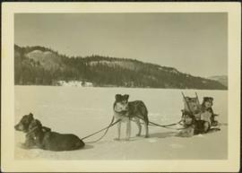
Previsualizar a impressão Fechar

Mostrar 1199 resultados

Archival description
1070 resultados com objetos digitais Mostrar resultados com objetos digitais
Dogsled Team
2009.5.2.54 · Item · [ca. 1934]
Parte de Taylor-Baxter Family Photograph Collection

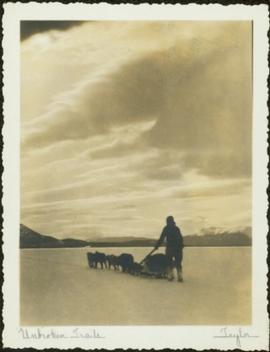
Photograph depicts a team of dogs pulling a sled and an unidentified person across a very flat area under heavy clouds. Mountains in background. Handwritten annotations on verso of photograph: "Unbroken Trails", "Taylor". Photograph speculated to have been taken near Atlin, B.C.

Tommy Tompkins Film Collection
2000.04 · Coleção · [196? - 198?]

The fonds consists of 5 - 16mm prints of Tompkins's films, and 48 slide boxes featuring natural history images. Includes "Nahani," "Where Timber Wolves Call," "White Bear of the Kalum," and "Waterway Adventure with Tommy Tompkins."

Sem título
Slim Williams and Dog Team
2006.20.9.7 · Item · 1933
Parte de Northern BC Archives Historical Photograph Collection

Photograph depicts Slim Williams and four members of his dog team in the centre of the image, with a group of men, women and children standing behind him looking towards the camera. Handwritten annotation along bottom of photograph reads: "'Slim' Williams and Dog Team From Alaska to Chicago 1933". It is believed this photograph was taken in Hazelton, BC. and documents Slim Williams on his way to the Chicago Fair.

6380 Bench Plan for 1972
2000.1.2.6.10 · Item · October 4, 1972
Parte de Cassiar Asbestos Corporation Ltd. fonds

This map depicts the pit layout and estimated waste extraction areas for 6380 bench. Extraction dates accompanied by its total tonnages are located within each planned area. Certain extraction dates are labeled with bench numbers. Annotated details include extraction dates, approximate total tonnages per area as well as extraction dates, total planned and broken tonnages, total tonnages from December 31, 1970 from a survey done in September 1, numerical bench markers as well as a rough colored legend depicting extraction month by color. The hand drawn plan consists of solid lines drawn with green, yellow, red and lead pencils.

6320 Bench Plan for 1972
2000.1.2.6.12 · Item · October 4, 1972
Parte de Cassiar Asbestos Corporation Ltd. fonds

This map depicts the pit layout and estimated waste extraction areas for 6320 bench. Extraction dates accompanied by its total tonnages are located within each planned area. Certain extraction dates are labeled with bench numbers. Annotated details include extraction dates, approximate total tonnages per area accompanied by extraction dates, total planned tonnages, total tonnages from December 31, 1971 as well as a rough colored legend depicting extraction month by color. The hand drawn plan consists of solid lines drawn with green, red, orange and lead pencils.

5840 & 5870 Bench Plan for 1972
2000.1.2.6.2 · Item · November 30, 1972
Parte de Cassiar Asbestos Corporation Ltd. fonds

This map depicts the generalized pit layout and estimated waste extraction areas for benches 5840 and 5870. Annotated details include numerical bench markers as well as extraction dates. The hand drawn plan consists of solid and dotted lines drawn with green and red pencil.

5840 Bench Plan for October 1972
2000.1.2.6.7 · Item · October 1972
Parte de Cassiar Asbestos Corporation Ltd. fonds

This map depicts the pit layout and estimated waste extraction areas for 5840 bench for the end of September to November. Extraction dates, approximate extraction tonnages and ore, waste and talus locations are included throughout the plan. Annotated details include numerical bench markers, extraction dates, approximate total tonnages as well as waste and ore tonnage calculations for October. The hand drawn plan consists of solid and broken lines drawn with red, blue, orange and lead pencils as well as black ink.

5870 Bench Plan for October 1972
2000.1.2.6.8 · Item · October 1972
Parte de Cassiar Asbestos Corporation Ltd. fonds

This map depicts the pit layout and estimated waste extraction areas for 5870 bench for the end of August to November. Extraction dates, approximate extraction tonnages and ore, waste and talus locations are included throughout the plan. Annotated details include numerical bench markers, extraction dates, approximate extraction tonnages, ore, waste and talus locations as well as waste, ore, talus and total tonnage calculations for October. The hand drawn plan consists of solid and broken lines drawn with red, blue, orange and lead pencils as well as black ink.

Group photo of five men
2008.27.8.3 · Item · [ca. 1920-1930?]
Parte de Knox McCusker Collection

Photograph is a group photo of five men standing around a tent in a wintery wooded landscape; Knox McCusker stands first man from the right, with hands in pockets. Caption on verso reads: “Youthful K.F.McC. on the right. Probably Northern Ontario or Manitoba”.

Bridge Crossing River Canyon
2009.5.1.72 · Item · [ca. 1900]
Parte de Taylor-Baxter Family Photograph Collection

Photograph depicts bridge built with wooden planks and poles, with triangles built into its frame. Water rapids in foreground, opposite shore in background behind bridge. This is speculated to be one of the bridges that crossed the Hagwilget Canyon on the Bulkey River since 1859, five kilometres from its confluence with the Skeena River. See items 2009.5.1.69 - 2009.5.1.71.

Walcott Suspension Bridge on Bulkley River
2009.5.1.73 · Item · 26 May 1932
Parte de Taylor-Baxter Family Photograph Collection

Handwritten annotation on recto of photograph: "Omineca Dist Walcott Suspension Bridge West Approach - looking East May 26 - 1932". Photograph depicts two white horses pulling a wagon in front of Walcott bridge. This bridge was moved from its original location in the Hagwilget Canyon, downstream from Walcott on the Bulkley River. It is a pedestrian bridge at the time of this photograph, though it was originally used by motor vehicles. Dirt road leading to bridge in foreground, with lumber and brush piles on either side. Trees and hills on opposite shore in background.

Jean Caux's Pack Train Leaving Ashcroft, B.C.
2009.5.1.78 · Item · 1909
Parte de Taylor-Baxter Family Photograph Collection

Photograph depicts men loading a line of approximately twenty mules facing large building in background with the sign: "[WBBAILEY?] ANDCO'S OFFICE." A second sign is posted on deck of building: "ALWAYS CURES! CHAMBERLAIN'S COUGH REMEDY." More men wearing suits watch from deck. Small building in hillside can be seen in background. Annotation along bottom recto of photograph reads: "Last Pack Train leaving Ashcroft for Hazelton -1909." Handwritten annotation on recto of photograph: "CATALINE 1909".

Hugh Taylor & Pack Train
2009.5.1.91 · Item · 1902
Parte de Taylor-Baxter Family Photograph Collection

Photograph depicts Hugh Taylor (facing camera) and other unidentified men packing horses and mules in cleared area, trees on hill in background. Animals are gathered around a pile of supplies, and it is believed that a power line crosses the midground. Handwritten annotation on envelope of negative: "Pack train on Blackwater 1902."

Dogsled Team
2009.5.2.57 · Item · [ca. 1934]
Parte de Taylor-Baxter Family Photograph Collection

Photograph depicts a team of dogs and sled resting in a very flat snow-covered area. Hills in background. Handwritten annotation on recto of photograph: "ATLIN."

Pack Dogs at Fort St. James
2006.20.11.7 · Item · June 1923
Parte de Northern BC Archives Historical Photograph Collection

Photograph depicts two First Nations men and two pack dogs loaded with bags. A small group of people can be seen in distance in front of semi-visible building. Stand of trees in background. Handwritten photo caption below photograph reads: "Indians & Pack Dogs - Fort St. James."

6350 Bench Plan for 1972
2000.1.2.6.9 · Item · October 4, 1972
Parte de Cassiar Asbestos Corporation Ltd. fonds

This map depicts the pit layout and estimated waste extraction areas for 6350 bench. Extraction dates accompanied by its total tonnages are located within each planned area. Annotated details include extraction dates, approximate total tonnages per area as well as extraction dates, total planned and broken tonnages and total tonnages from December 31, 1970 from a survey done in September 30. The hand drawn plan consists of solid lines drawn with red, green and orange colored pencils.

Ore Type and Geology Map
2000.1.2.6.13 · Item · December 31, 1972
Parte de Cassiar Asbestos Corporation Ltd. fonds

This map depicts the ore type and geology that can be found among each of the bench layers. Classifications and grades of ore are included within it. Different bench layers are included in the map. Annotations include a title in the back of the map written out as "1972 BENCH PLANS".

2000.1.2.1 · Item · February 1952
Parte de Cassiar Asbestos Corporation Ltd. fonds

The topographic map shows mine and campsite holdings within the proposed mine site. Asbestos deposits, the tramline and water bodies, such as Troutline Creek, are also included.

Annotations include certain lot titles being crossed out as well as as indication of missing survey information.

Cassiar Asbestos Corporation 1972 Bench Plans
2000.1.2.6 · Dossiê/Processo · 1972
Parte de Cassiar Asbestos Corporation Ltd. fonds

A set of 13 maps showing approximate waste extraction areas for different benches during certain months of 1972. Extraction dates are included accompanied by estimated total tonnages for each planned extraction area. All plans are hand drawn using colored pencils, lead and black ink. Approximate calculations of extraction tonnages are included within certain months. Numerical bench markers are included. Total tonnages from the previous year and previous surveys are included within certain plans.

6290 Bench Plan for November 1972
2000.1.2.6.4 · Item · November 1972
Parte de Cassiar Asbestos Corporation Ltd. fonds

This map depicts the generalized pit layout and estimated waste extraction areas for 6290 bench for the month of November. Annotated details include numerical bench markers and waste extraction dates. The hand drawn plan consists of solid and dotted lines drawn with green, orange, red, blue and lead pencil.

Grand Trunk Pacific Railway Passenger Train
2009.5.1.75 · Item · 14 June 1911
Parte de Taylor-Baxter Family Photograph Collection

Handwritten annotation on verso of photograph: "G.T.P. 1st Passenger Train From Prince Rupert. Mile 45. June. 14th 1911. Copyright. F. Button. PHOTO. Pr. Rupert. No. 240." Photograph depicts three men (two sitting on chairs) on caboose of train. Power poles run parallel to tracks, which curve to the right of the image. Train tracks in foreground, forest and mountain in background.

Jean Caux's Pack Train
2009.5.1.77 · Item · 1897
Parte de Taylor-Baxter Family Photograph Collection

Photograph consists of Jean Caux and several men loading supplies onto a horse and mule pack train. Large building in background. Annotation along bottom recto of photograph reads: "Jean Caux's Pack Train, loading at Harvey Baileys for Babine Lake - 1897." Handwritten annotations on recto of photograph: "CATALINE 1897" "Born in 1856 in Mexico on Spanish border. Died at Hazelton 1922 burried in old cemetery."

Model T Belonging to A.K. Bourchier
2009.5.3.141 · Item · [ca. 1917]
Parte de Taylor-Baxter Family Photograph Collection

Photograph depicts car parked in dirt yard. House stands in background on right, surrounded by miscellaneous items. White tent stands in left background. Water and shore visible in distance. House believed to belong to the Bourchier's niece Jean (see items 2009.5.3.120 & 2009.5.3.122).

Stuart River Ferry
2006.20.11.6 · Item · June 1923
Parte de Northern BC Archives Historical Photograph Collection

Photograph depicts a small car and passengers on log ferry in foreground and one man on dock. Stuart River and forested banks in background. Handwritten photo caption below photograph reads: "Stuart River Ferry."