Mostrando 265 resultados

Archival description
20000 tons pontoon floating dry dock
2009.7.1.264 · Item · [ca. 1880-1920]
Parte de Archdeacon W. H. Collison fonds

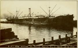
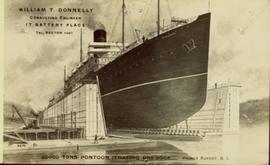
Illustration of a large ocean liner in dry dock. The name "Minnesota" is inscribed on the top right side of vessel. Annotation on recto reads: "William T. Donnelly Consulting Engineer 17 Battery Place Tel. Rector 1491 20000 tons pontoon floating dry dock Prince Rupert, BC"

Moving mountains at Prince Rupert BC
2009.7.1.265 · Item · 24 April 1913
Parte de Archdeacon W. H. Collison fonds

Photograph of a large explosion on a rocky shoreline. A bridge is visible in the foreground and a body of water is partially visible in the background. Annotation on recto reads: "McRae Bros Moving Mountains at Prince Rupert BC Apr 24th"

First train leaving Prince Rupert
2009.7.1.266 · Item · 14 June 1911
Parte de Archdeacon W. H. Collison fonds

Photograph of a large crowd gathered in front of a Grand Trunk Pacific train. Residential buildings atop a hill are visible in the background. Annotation on recto reads: "First Train Leaving Prince Rupert June 14 1911"

SS Arna arrived in Prince Rupert BC
2009.7.1.267 · Item · 30 March 1914
Parte de Archdeacon W. H. Collison fonds

Photograph of ocean liner SS Arna docked in a harbour. Foreground shows two individuals on a dock in the lower right corner and a large pile of lumber in the lower left corner. Annotation on recto reads: "S.S. Arna arrived in Prince Rupert B.C March 30th 1914"

GTP SS Prince Rupert Sept 28th
2009.7.1.268 · Item · 28 September 1920
Parte de Archdeacon W. H. Collison fonds

Photograph of a partially sunken sailboat near a harbour. Individuals on debris and in a rowboat are surveying the damage. Annotation on recto reads: "GTP. SS Prince Rupert Sept 28th 1920 McRae." Handwritten annotation on verso reads "CTP "Prince Rupert" Sunk at Prince Rupert BC 1920."

Prince Rupert wharf and waterfront
2009.7.1.273 · Item · [ca. 1880-1920]
Parte de Archdeacon W. H. Collison fonds

Photograph of a small vessel on the ocean with a dock and harbour buildings in the foreground. Tents and piles of lumber can be seen among the buildings. Annotation on recto reads: "The Wharf, Prince Rupert, BC. 1657." Printed annotation on verso reads "The Wharf, Prince Rupert, BC J. Howard A. Chapman, Victoria. BC. 1657."

Side view of Prince Rupert wharf
2009.7.1.274 · Item · May 1908
Parte de Archdeacon W. H. Collison fonds

Side view photograph of a small harbor close by a shoreline littered in organic debris. A foggy mountain range is visible in the background. Annotation on recto reads: "Wharf and Harbor Prince Rupert. May 1908 JDA."

Overhead view of downtown Prince Rupert
2009.7.1.277 · Item · [ca. 1880-1920]
Parte de Archdeacon W. H. Collison fonds

Wide angle photograph of many buildings scattered in a clear cut area. Foreground shows several businesses, including "Kelly Carruther's Supply" and "Prince Rupert Hardware and Supply Co." Some remaining forest is visible in the background. Annotation on recto reads: "Prince Rupert, BC 1659."

2009.7.1.279 · Item · 6 August 1909
Parte de Archdeacon W. H. Collison fonds

Wide angle photograph showing 3rd and 2nd Avenue in Prince Rupert. Many buildings, both commercial and residential, and some tents are situated along the wooden roads. Annotation on recto reads: "Prince Rupert, BC. 3rd Avenue 2nd Avenue Allen Photo Aug 6/09."

2009.7.1.281 · Item · [ca. 1880-1920]
Parte de Archdeacon W. H. Collison fonds

Wide angle photograph of Prince Rupert sometime during the winter. There is snow on the ground and a marge mountain range is visible in the background. Annotation on recto reads: "Prince Rupert looking East from Waterworks J.D.A Pho 5/2."

2009.7.1.282 · Item · 6 August 1909
Parte de Archdeacon W. H. Collison fonds

Wide angle photograph showing the intersection of 3rd Avenue and 6th Street, as well as 5th Street in Prince Rupert. Many buildings are visible along the wooden street including a building in mid-construction. Annotation on recto reads: "Prince Rupert, BC. 6th Street 3rd Ave. 5th St Allen Photo Aug 6/09."

Street down to the shore
2009.7.1.284 · Item · 1907
Parte de Archdeacon W. H. Collison fonds

View of the road descending to the waterfront. Buildings and forested area are visible on either side of street. Annotation on recto reads: "Prince Rupert BC. '07."

2011.3.3.82 · Item · 1 July 1910
Parte de North Coast & Central BC Postcard Collection

Slightly elevated street view of buildings and sidewalks being constructed in Prince Rupert, BC. Printed annotation on recto reads: "Photo by McRae Bros. Third Ave Prince Rupert, BC." Handwritten annotation on verso reads: "Dear Florence you better [illegible] will try and answer it in a few day I am well I will try and send you some cards I will stay here till in Dec Write[??] me and send me some cards I am 15 mile in the mountains Write your Bro LS Bill." Postcard is addressed to: "Miss Florence Wilson P.O. Box 1178 Worcester Mass U.S.A." A 2 cent Canadian stamp is affixed on verso. Postmark reads: "Prince Rupert BC Jul 1 10."

Moving mountains in Prince Rupert, BC
2011.3.3.86 · Item · 17 July 1913
Parte de North Coast & Central BC Postcard Collection

Photograph of a large explosion on a rocky shoreline. A bridge is visible in the foreground and a body of water is partially visible in the background. Printed annotation on recto reads: "McRae Bros Moving Mountains at Prince Rupert BC Apr 24th" Handwritten annotation on verso reads: "Rupert. July 17 1913. Dear [illegible]. Just a card for that album if you've got any room left by now. This is one of the blasts for the clearing of the drydock up here. [Illegible] W.M." Postcard is addressed to: "Miss C.M. Ranip[??] 931 Northlane Av.[sic] Seattle Wash." Two Canadian one cent stamps are affixed on verso. Postmark reads: "Prince Rupert BC. PM Jul 17 13."

Gordon Wyness Album
2020.05 · Colección · 1936

In 1936, Gordon Young Wyness was employed by Philip M. Monckton, a B.C. Land Surveyor. Between June 5 and October 8, Wyness joined Monckton and a group of others on a land survey expedition in northwestern BC. The survey crew travelled to various locations in the area including Telkwa, Hazelton, Burns Lake, Francoise Lake, Vanderhoof, Prince George, Quesnel, Lytton, and Hope. Wyness documented their journey in this photograph album. Based on the photographs, it appears that the crew led by Philip Monckton consisted of Jack Lee and Gordon Wyness; Mrs. Lavender Monckton (nee O'Hara) also accompanied the group.

In addition to the 50 photographs included in the album, this collection also includes five additional unique photographs that accompanied the album.

Sin título
Snoqualmie Pass summit
2020.05.01 · Item · 6 June 1936
Parte de Gordon Wyness Album

Photograph depicts a man, likely Gordon Wyness, sitting on the front of a 1930 Buick Series 40 car at the Snoqualmie Pass summit.

2020.05.05 · Item · October 1936
Parte de Gordon Wyness Album

Photograph depicts Mount Begbie, noted by Wyness to be the highest point on the Cariboo Highway at mile 85. Mount Begbie is located at approximately 51°28'33''N, 121°22'00''W, on the east side of Cariboo Hwy, between 70 Mile House and 100 Mile House, in the Lillooet Land District. Wyness annotated this photograph with the statement that they "tied this one in"; 'tying in' is a land survey term, implying that the crew may have also been surveying in this area.

2020.05.06 · Item · October 1936
Parte de Gordon Wyness Album

Photograph depicts Mount Begbie, noted by Wyness to be the highest point on the Cariboo Highway at mile 85. Mount Begbie is located at approximately 51°28'33''N, 121°22'00''W, on the east side of Cariboo Hwy, between 70 Mile House and 100 Mile House, in the Lillooet Land District. Also visible in this photograph is the Cariboo Highway road.

2020.05.07 · Item · October 1936
Parte de Gordon Wyness Album

Photograph depicts Mount Begbie, noted by Wyness to be the highest point on the Cariboo Highway at mile 85. Mount Begbie is located at approximately 51°28'33''N, 121°22'00''W, on the east side of Cariboo Hwy, between 70 Mile House and 100 Mile House, in the Lillooet Land District. Also visible in this photograph is the Cariboo Highway road.

2020.05.08 · Item · October 1936
Parte de Gordon Wyness Album

Photograph depicts a view of the Fraser River from what Wyness calls "Fraser Mountain". There are a number of places named "Mount Fraser" in British Columbia, but the exact location of where this photograph was taken is unclear.

2020.05.10 · Item · Sept. 1936
Parte de Gordon Wyness Album

Photograph depicts (from left to right) Gordon Wyness, Philip Monckton, and Lavender Monckton by their 1930 Buick Series 40 car in the Williams Lake area. In this image, the car may be broken down; Wyness noted that they "were forced to spend the nite in a school house due to condenser burning out in the car". Wyness also noted that they had "just finished tying in Fraser Mtn", suggesting that they had just completed survey work in the Fraser Mountain area.

2020.05.11 · Item · [Sept. or Oct. 1936]
Parte de Gordon Wyness Album

Photograph depicts (from left to right) Gordon Wyness and Jack Lee in front of the Fort St. James sign, which reads "First white settlement in British Columbia. Established by the North West Company in 1806 by Simon Fraser and John Stuart and taken over by the Hudson's Bay Company in 1821. - General Merchandise Visitors Welcome".

2020.05.13 · Item · [Sept. or Oct. 1936]
Parte de Gordon Wyness Album

Photograph depicts (from left to right) Jack Lee, Gordon Wyness, Jessie McInnes, and Archie McInnes at Pioneer Ranch.

In 1903, brothers Neil and Archie McInnes pre-empted a section of land two miles east of Cote Flat, each taking half. Archie McInnes' land later became known as Pioneer Ranch (later known as the Barnett Ranch); Neil McInnes' land became Meadowbrook Ranch. Archie McInnes married Jessie Aitken in October 1905. Pioneer Ranch became known as a stop-over for travellers en route from Hazelton to the Ootsa Lake area via the Telegraph Trail. Archie and Jessie McInnes had three daughters: Vera (m. Ivan Frank), Ivy (m. Eric Strimbold), and Neva (m. John Ivan Nickolichuk).

2020.05.14 · Item · [Sept. or Oct. 1936]
Parte de Gordon Wyness Album

Photograph depicts (from left to right) Jack Lee, Philip Monckton, Jessie McInnes, and Archie McInnes at Pioneer Ranch.

In 1903, brothers Neil and Archie McInnes pre-empted a section of land two miles east of Cote Flat, each taking half. Archie McInnes' land later became known as Pioneer Ranch (later known as the Barnett Ranch); Neil McInnes' land became Meadowbrook Ranch. Archie McInnes married Jessie Aitken in October 1905. Pioneer Ranch became known as a stop-over for travellers en route from Hazelton to the Ootsa Lake area via the Telegraph Trail. Archie and Jessie McInnes had three daughters: Vera (m. Ivan Frank), Ivy (m. Eric Strimbold), and Neva (m. John Ivan Nickolichuk).

2020.05.15 · Item · [Sept. or Oct. 1936]
Parte de Gordon Wyness Album

Photograph depicts (from left to right) Gordon Wyness and Jack Lee at a camp scene "at Bobtail" (possibly Bobtail Lake) near Vanderhoof. As noted in the album caption, the crew had "just returned from Vanderhoof". The telegraph cabin roof and their 1930 Buick Series 40 car is visible at right.