Showing 973 results

Archival description
28 results with digital objects Show results with digital objects
2023.7.2.09 · Bestanddeel · 1986
Part of Grant Hazelwood fonds

File consists notes, correspondence, summary reports, inventory data, and a map regarding capability classification for Bowser Lake. The map is a "clean copy" of Grant Hazelwood's ungulate biophysical map without symbols. Summary reports include:

  • Grant Hazelwood, "Ungulate Capability Classification"
  • Grant Hazelwood, "Winter Flights, February 1986"
  • "Ungulate Biophysical Mapping in the Stikine-Iskut Area"
2023.7.2.06 · Bestanddeel · Apr. 1985
Part of Grant Hazelwood fonds

File consists of an original "Mount Klappan Access Road Study" proposal for consulting services to the BC Ministry of Industry and Small Business Development by Phillips Barratt Kaiser Engineering Ltd. in association with Associated Engineering (B.C.) Ltd.

2023.7.2.05 · Bestanddeel · Oct. 1984
Part of Grant Hazelwood fonds

File consists of an original "Mount Klappan Anthracite Project" document by Gulf Canada Resources Ltd. Includes accompanying map entitled "Gulf Canada Resources Inc.: Northwest British Columbia" that shows proposed coal mine sites in the Mount Klappan area, near Spatsizi Wilderness Park and Tatlatui Provincial Park.

2023.7.2.04 · Bestanddeel · May 1984
Part of Grant Hazelwood fonds

File consists of a copy of "Preliminary Environmental Assessment of Railway Corridor Options to Service Mount Klappan Coal Project and the Northwest Region of British Columbia" (1984) by the Industrial and Energy Project Evaluation Section, Planning and Assessment Branch of the BC Ministry of Environment.

2023.7.2.02 · Bestanddeel · 1984-1986
Part of Grant Hazelwood fonds

File consists of Grant Hazelwood's notes and collected correspondence created in conjunction with the BC Ministry of Environment's "Upper Nass Assessment Project", a project that included the biophysical mapping of the Northwest-Klappan Road Access Area. Includes a summary document entitled "Klappan Access Road Project - Wildlife Component", as well as Hazelwood's handwritten species inventory notes.

2023.7.2.01 · Bestanddeel · 1985
Part of Grant Hazelwood fonds

File consists of project planning documents for the BC Ministry of Environment's "Upper Nass Assessment Project", a project that included the biophysical mapping of the Northwest-Klappan Road Access Area. Grant Hazelwood (Alpenglow Resources) was hired as the wildlife biologist for to undertake this project work. Includes Hazelwood's employment information for the project, project terms of reference, and a project summary.

2023.2.2.5.5 · Bestanddeel · 1991
Part of Dr. Paul Sanborn fonds

Original Land Resource Research Institute soil description detail forms prepared by Scott Smith for 3 locations, annotated on covers as follows:
SS91010 Lost Chicken Regosol Paleosol 26/6/91
SS91011 Lost Chicken Ash in Felty Peat 27/6/91
SS91013 Lost Chicken Mine “Up the Creek” ash site 28/6/91

Each of the three forms contains an attached annotated Polaroid photograph depicting each site.

2023.2.2.2.7 · Bestanddeel · 1996-2005
Part of Dr. Paul Sanborn fonds

Data sets associated with the Arocena & Sanborn 1999 regional soil mineralogy study:

  • S234FINL.XLS [data report for mineral horizons from MoF Analytical Chemistry Laboratory, June 20 1996]
  • S235FINL.XLS [data report for organic horizons from MoF Analytical Chemistry Laboratory, June 20 1996]
  • SAMPLIST.XLS [conversion table for sample numbers used in MoF lab data reports]
  • Fe Al extractions.xlsx [assembled from lab data report by L. Arocena for oxalate & dithionite extractions; pyrophosphate extraction data from MoF lab]
  • MINSTUDY.XLS [consolidated lab data for organic & mineral horizons, except for BaCl2 exchangeable cations]
  • MINCEC.XLS [BaCl2 exchangeable cations & Morgan’s extraction for organic & mineral horizons]
2023.2.2.1.1.2 · Bestanddeel · 1988-1990
Part of Dr. Paul Sanborn fonds

During a year away from studies in 1987-88, Dr. Paul Sanborn developed a successful grant proposal to the Science Council of BC (SCBC) to pursue a postdoctoral project with Dr. Tim Ballard in relation to sulphur-deficient soils in BC and prescribed fire. This project built on an existing broadcast burning study conducted by Macmillan Bloedel Ltd. near Port Alberni on Vancouver Island, led by Bill Beese (later at Vancouver Island University). Dr. Sanborn's work addressed sulphur forms and amounts in the soils at these sites, and the chemical processes influencing sulphur availability in relation to prescribed fire.

Only one part of this work was eventually published:
Sanborn, P.T. and T.M. Ballard. 1991. Combustion losses of sulphur from conifer foliage: Implications of chemical form and soil nitrogen status. Biogeochemistry 12: 129–134. https://doi.org/10.1007/BF00001810

The remainder of the work was documented in this Project Completion Report to SCBC, dated February 28, 1990, and entitled "Effects of Prescribed Fire on Sulphur in Forest Soils".

Thirty-four data files were selected for archival retention. There is some redundancy of content among these, with some formatted for incorporation as tables in the report appendices, and others containing some of the same data, but set up as input files for a statistics program. These account for almost all of the data listed in the Project Completion Report appendices. No glossary of variable names is provided, but these should be identifiable by referring to the Report.
2023.2.2.1.2.3 · Bestanddeel · 2002-2005
Part of Dr. Paul Sanborn fonds

Data sets associated with the Cluculz retrospective study (E.P. 886.10):

  • 082036.xls -- Elemental analysis (XRF) for mineral horizon samples from profile at Cluculz EP 886.10 site
  • CLUCINC.xls -- Summary chemical properties for composite samples in aerobic incubation
  • Cluculz Ck 2002 Foliar Analysis.xls -- Analyzed for individual single-tree plots
  • Cluculz Ck 2002 Forest Floor.xls -- Forest floor mass data
  • Cluculz composite list (2003 samples).xls -- Composite groups (3 original samples in each) used for organic & mineral soils
  • Cluculz composite list (incubation experiment).xls -- Composite groups (3 original samples in each) used for organic & mineral soils
  • Cluculz composite list for incubations (2003 samples).xls -- Composite groups (3 original samples in each) used for organic & mineral soils
  • Cluculz Creek S mineralization - initial fractions (2).xls -- S fractions - organic & mineral soil composites
  • Cluculz Creek S mineralization - initial S fractions.xls -- S fractions - organic & mineral soil composites
  • Cluculz Creek S mineralization (IC).xls -- S mineralization data for aerobic incubation - organic & mineral soils
  • Cluculz foliar and soil data.xls -- Chemical properties of foliage, composite forest floors, composite mineral soils
  • Cluculz pH.xls -- pH - organic & mineral soil composites
  • Cluculz S fraction graphs.xls -- S fractions - organic & mineral soil composites
  • Elemental Analysis of Standard by XRF (2005).xls -- Published & XRF analysis of CANMET TILL-1 soil standard (used in Cluculz XRF analysis)
2023.2.2.1.3.8 · Bestanddeel · 2003-2010
Part of Dr. Paul Sanborn fonds

Data sets for the Sulphur stable isotope tracer study (E.P. 886.15) include:

  • 03-095 UNBC PS-For.xls Particle size analyses (Kenneth Creek 0-20 & 20-40 cm)
  • 03-096 UNBC PS-For.xls Particle size analyses (Holy Cross 0-20 & 20-40 cm)
  • 082037.xls XRF elemental analysis (Holy Cross pedon)
  • 082038.xls XRF elemental analysis (Kenneth Creek pedon)
  • 084996.xlsx XRF elemental analysis (HC & KC parent materials)
  • EP 886 15 S isotope data (2001-2005) - foliage_completed (Feb 18).xls Pine foliage d34S (total S & total SO4-S)
  • EP 886.15 2003 Foliage & Soil Chemistry Summary.xls
  • EP 886.15 Foliar Analyses (selected) 2001-2006.xls Total N & S, SO4-S
  • EP 886.15 Holy Cross & Kenneth Creek 2005 foliage.xls
  • EP 886.15 Holy Cross & Kenneth Creek 2006 foliage.xls
  • EP 886.15 Holy Cross 2001 FH (S516FINL).xls
  • EP 886.15 Holy Cross 2001 Foliage (T727FINL).xls
  • EP 886.15 Holy Cross 2001 Litter (S515FINL).xls
  • EP 886.15 Holy Cross 2001 Mineral Soil (0-20 cm) (S507FINL).xls
  • EP 886.15 Holy Cross 2002 Foliage (T785FINL).xls
  • EP 886.15 Holy Cross 2003 FH (S642FINL).xls
  • EP 886.15 Holy Cross 2003 Foliage (T836FINL).xls
  • EP 886.15 Holy Cross 2003 Litter (S641FINL).xls
  • EP 886.15 Holy Cross 2003 Mineral Soil (0-20 cm) (S643FINL).xls
  • EP 886.15 Holy Cross 2004 FH (S702FINL).xls
  • EP 886.15 Holy Cross 2004 Foliage (T904FINL).xls
  • EP 886.15 Holy Cross 2004 Litter (S701FINL).xls
  • EP 886.15 Holy Cross 2004 Mineral Soil (0-20 cm) (S703FINL).xls
  • EP 886.15 Kenneth Creek 2001 FH (S521FINL).xls
  • EP 886.15 Kenneth Creek 2001 Foliage (T727FINL).xls
  • EP 886.15 Kenneth Creek 2001 Litter (S520FINL).xls
  • EP 886.15 Kenneth Creek 2001 Mineral Soil (0-20 cm) (S508FINL).xls
  • EP 886.15 Kenneth Creek 2001 Mineral Soil (20-40 cm) (S509FINL).xls
  • EP 886.15 Kenneth Creek 2002 Foliage (T785FINL).xls
  • EP 886.15 Kenneth Creek 2003 FH (S645FINL).xls
  • EP 886.15 Kenneth Creek 2003 Foliage (T837FINL).xls
  • EP 886.15 Kenneth Creek 2003 Litter (S644FINL).xls
  • EP 886.15 Kenneth Creek 2003 Mineral Soil (0-20 cm) (S646FINL).xls
  • EP 886.15 Kenneth Creek 2003 Mineral Soil (20-40 cm) (S647FINL).xls
  • EP 886.15 Kenneth Creek 2004 FH (S705FINL).xls
  • EP 886.15 Kenneth Creek 2004 Foliage (T905FINL).xls
  • EP 886.15 Kenneth Creek 2004 Litter (S704FINL).xls
  • EP 886.15 Kenneth Creek 2004 Mineral Soil (0-20 cm) (S706FINL).xls
  • EP 886.15 Kenneth Creek 2004 Mineral Soil (20-40 cm) (S707FINL).xls
  • EP 886.15 Sample Inventory.xls Listing of MoF Lab Job No.'s
  • Fertilizer March 2003.xls d34S data for commercial fertilizer S sources
  • hc_2002.xls Initial (2002) pine tree measurement data - Holy Cross
  • kc_2002.xls Initial (2002) pine tree measurement data - Kenneth Creek
2012.13.2.02.61 · Bestanddeel · 1989
Part of J. Kent Sedgwick fonds

File consists of notes and reproductions relating to land exploration and surveying in British Columbia by Alfred R.C. Selwyn, who was a British geologist and public servant, director of the Geological Survey of Victoria from 1852 to 1869, director of the Geological Survey of Canada from 1869 to 1894, and President of the Royal Society of Canada from 1895 to 1896. Includes: "Photography: Mirror of the Past" American History magazine special edition (Sept. 1989) and a photocopied article "Ninety Years Later" by F.C. Swannell from The Beaver magazine (1956). File also includes reproduced photographs depicting scenes from Selwyn's exploration around British Columbia (1989).

2006.18.1.33 · Bestanddeel · 1994
Part of Aleza Lake Research Forest Society fonds

File consists of a compilation of Experimental Projects in the Prince George Region. This compilation work was done by Stewart Taylor of the Ministry of Forests. Included are Experimental Projects regarding the Aleza Lake Research Forest that were selected from Taylor's larger project, which contained over 400 EP summaries for the Prince George Region.

2006.18.4.21 · Bestanddeel · 1951
Part of Aleza Lake Research Forest Society fonds

File contains an original copy of a United States Department of Agriculture Handbook No. 6 "Northeastern Loggers' Handbook" by Fred C. Simmons. This handbook includes detailed information about logging tools and techniques, many of which would have been used in British Columbia logging practices.

2006.18.1.12 · Bestanddeel · 2006-2007
Part of Aleza Lake Research Forest Society fonds

File consists of:

  • David Mills, "Aleza Lake Research Forest Historical Internship Summary" (2 Jan. 2007), 26 p. - In print and original digital .doc file
  • David Mills, "Aleza Lake Forest Experiment Station Socio-Economic Time Line 1905-1937" (2007), 68 p. - In print and original digital .doc file
  • ALRFS employment paperwork for David Mills, the ALRFS Natural Resource History Intern
  • Research notes, including a copy of a map of the town of Aleza Lake in the 1920s
2016.7.3.49 · Bestanddeel · June 1990
Part of Dr. Joselito Arocena fonds

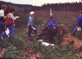
File consists of slides depicting Joselito Arocena's University of Alberta PhD fieldwork. Arocena started his PhD fieldwork in 1988 under the supervision of Dr. Steve Pawluk.

2016.7.3.47 · Bestanddeel · June 1988
Part of Dr. Joselito Arocena fonds

File consists of slides depicting Joselito Arocena's University of Alberta PhD fieldwork at a research site in the Alberta foothills near Hinton. Arocena had just started his PhD fieldwork in 1988 under the supervision of Dr. Steve Pawluk. Persons depicted in the photographs include: Joselito Arocena (red hat), Dr. Steve Pawluk (blue hat), and Dr. Marvin Dudas. The photographer was Paul Sanborn, who was near completion of a 1-year post-doc with Dr. Pawluk.

2016.7.3.48 · Bestanddeel · May 1988
Part of Dr. Joselito Arocena fonds

File consists of slides depicting Joselito Arocena's University of Alberta PhD fieldwork at a research site in the Alberta foothills near Hinton. Arocena had just started his PhD fieldwork in 1988 under the supervision of Dr. Steve Pawluk. Persons depicted in the photographs include: Joselito Arocena, Dr. Steve Pawluk (blue hat), and Paul Sanborn.

2006.18.6.05 · Bestanddeel · Jan. 1992
Part of Aleza Lake Research Forest Society fonds

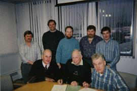
File consists of a photograph commemorating the signing of the first Aleza Lake Research Forest Management Plan. Front row, left to right: Ken Pendergast, BC Forest Service Prince George District Manager; Harry Coates, BCFS Forest Research Technician (1957-1993); John Revel, BCFS Silviculture Forester (1960-1993). Back row, left to right: Mike [?], BCFS Prince George Silviculture Manager; Henry Benskin, BCFS Research Branch; Michael Jull, BCFS Research Silviculturist, Prince George Region; Dan Lousier, BCFS Prince George Region Research Section Head; Brian Harding, Northwood Pulp & Timber Ltd. Woodlands Manager.

2006.18.6.01 · Bestanddeel · [196-?]
Part of Aleza Lake Research Forest Society fonds

Photographs are panoramas taken from the Churchill BC Forest Service Lookout, located at latitude 54°04' and longitude 122°16'. The photographs were bound together and include a transparent grid that was intended to be used for locating forest fires.

2016.7.3.46 · Bestanddeel · 1995-2005
Part of Dr. Joselito Arocena fonds

File consists of digital photographs from Dr. Joselito Arocena's external hard drives. Images depict a variety of subjects, including research imagery, photographs from Arocena's travels, UNBC, the construction of the UNBC Northern Medical Program building, Prince George, and the Northern BC region.

NRES brochures
2016.7.3.41 · Bestanddeel · 2003-2005
Part of Dr. Joselito Arocena fonds

File consists of digital images for use in UNBC NRES brochures. Also includes accompanying text for the brochures.

Yukon 2002
2016.7.3.38 · Bestanddeel · Oct. 2002
Part of Dr. Joselito Arocena fonds

File consists of slides depicting a visit to Yukon Territory in 2002, including Dawson City.