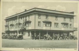
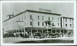
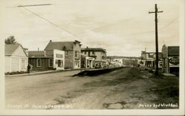
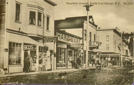
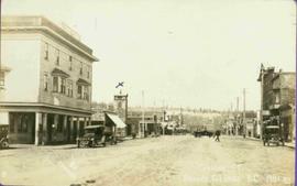
Print preview Close

Showing 887 results

Archival description
887 results with digital objects Show results with digital objects
2011.3.2.10 · Item · [ca. 1910]
Part of North Coast & Central BC Postcard Collection

Street scene showing people, dog, team of horses & wagon. Signage reads: “Beds; Mecca Café; Hardware.” Printed annotation on recto reads: “Hamilton Avenue, South Fort George, B. C. No. 110.” Verso displays cancelled 1 cent Canadian Postage Stamp and handwritten message in ink is addressed to Mr. Eathan Villard Burt Mish, U.S.A.

2011.3.2.17 · Item · 1921
Part of North Coast & Central BC Postcard Collection

Photograph of George Street in Prince George B.C. Cars, people, and signage are visible. Printed annotation on recto reads: “George St. Prince George B.C. 1921 R7 by Moore” There is an “X” in ink over the fire hall. Handwritten annotation in ink on verso reads: “This view is also looking north and where I have put the X is the one and only fire hall and you can see the fire engine in the street. This is the main street.”

Prince George to Tete Jaune
2011.3.4.14 · Item · [ca. 1901-1915]
Part of North Coast & Central BC Postcard Collection

Stern wheeler in river. Handwritten annotation in pencil on verso reads: “Prince George to Tete Jaune” Hand written message in ink on verso is addressed to “Mademoiselle Elisabeth Joliet, Terrguy – Les Dijore Cote a Or France”

2011.12.02 · Item · ca. 1950
Part of Giscome, BC Historical Photograph collection

Photo depicts a street perspective of George St., in Prince George, BC, ca. 1950. Annotation recto reads: "George St. Prince George BC Photo by J Wrathall." Handwritten annotation in pen on verso of postcard reads: “This is the Hastings Street of Prince George. This & 3rd Streets are the main thoroughfares.”

CNR Prince George
2013.6.36.1.039.02 · Item · 1966
Part of David Davies Railway Collection

Photograph depicts a rail bridge over the Fraser River. Canter levelled on both sides were vehicle roadways which ceased to be used in 1987 when a new road bridge was supposed to be completed. The right lane took cars into the city of Prince George.

Highway 97
2012.13.1.3.022 · Item · Oct. 1975
Part of J. Kent Sedgwick fonds

Image depicts Highway 97 at 15th Ave. looking north. Map coordinates 53°54'42.1"N 122°46'53.1"W

Trailers for Sale
2012.13.1.3.027 · Item · Oct. 1975
Part of J. Kent Sedgwick fonds

Image depicts mobile homes for sale on Cowart Road looking northeast with Simon Fraser Bridge in background. Map coordinates 53°52'39.3"N 122°46'13.1"W

Woodwards
2012.13.1.3.029 · Item · Oct. 1975
Part of J. Kent Sedgwick fonds

Image depicts Parkwood Place taken from Connaught Hill looking west with the hospital in the background. Map coordinates 53°54'39.9"N 122°45'02.5"W

Prince George
2012.13.1.3.042 · Item · Nov. 1977
Part of J. Kent Sedgwick fonds

Image depicts downtown Prince George looking northwest across Dominion Street. Map coordinates 53°54'48.7"N 122°44'45.6"W

View from City Hall
2012.13.1.3.045 · Item · Jan. 1978
Part of J. Kent Sedgwick fonds

Image depicts a view of Prince George from City Hall looking northeast with the pulp mills in the background. Map coordinates 53°54'46.3"N 122°44'41.9"W

View from Gunn Point
2012.13.1.3.058 · Item · Nov. 1979
Part of J. Kent Sedgwick fonds

Image depicts a view of Prince George from Gunn Point in the L.C. Gunn Park looking north. Map coordinates 53°54'26.2"N 122°43'35.8"W.

View from Gunn Point
2012.13.1.3.062 · Item · Nov. 1979
Part of J. Kent Sedgwick fonds

Image depicts a view of Prince George from Gunn Point in the L.C. Gunn Park looking north. Map coordinates 53°54'26.2"N 122°43'35.8"W.

View from Gunn Point
2012.13.1.3.063 · Item · Nov. 1979
Part of J. Kent Sedgwick fonds

Image depicts a view of Prince George from Gunn Point in the L.C. Gunn Park looking north. Map coordinates 53°54'26.2"N 122°43'35.8"W.

View from Gunn Point
2012.13.1.3.066 · Item · Nov. 1979
Part of J. Kent Sedgwick fonds

Image depicts a view of Prince George from Gunn Point in the L.C. Gunn Park looking north. Map coordinates 53°54'26.2"N 122°43'35.8"W.

View from Gunn Point
2012.13.1.3.067 · Item · Nov. 1979
Part of J. Kent Sedgwick fonds

Image depicts a view of Prince George from Gunn Point in the L.C. Gunn Park looking north. Map coordinates 53°54'26.2"N 122°43'35.8"W.

Downtown Prince George
2012.13.1.3.079 · Item · May 1984
Part of J. Kent Sedgwick fonds

Image depicts downtown Prince George taken from City Hall looking northwest. Map coordinates 53°54'46.2"N 122°44'43.9"W

Beehive Burner
2012.13.1.3.089 · Item · 12 Oct. 1989
Part of J. Kent Sedgwick fonds

Image depicts a Beehive Burner along the Nechako on River Road. Map coordinates 53°55'34.1"N 122°44'58.0"W.