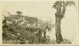
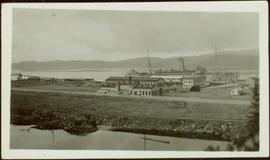
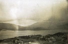
Photograph of post office and neighbouring building. Both buildings are composed of wood and tent materials. Annotation on recto reads: "Post Office & Customs House, Prince Rupert, BC."
Members of the Collison family casually fishing from a large dock. Handwritten annotation on verso reads: "Collison family fishing from dock (Portland[?] Canal) {Max Elsie Henry Will Arthur Herbert}."
Large crowd gathered on the street in downtown Prince Rupert around a lavishly decorated arch which reads "Come One Let 'Em All Come Come All. Welcome to Prince Rupert." Annotation on recto reads: "Arch Prince Rupert, BC. Dominion Day Celebration 1909. Allen Photo."
Photograph of several floats parading down Second Avenue in Prince Rupert. A large crowd is gathered. Annotation on recto reads: "Photo by MacRae Bros Prince Rupert BC Prince Rupert B."
Photograph of the Prince Rupert wharf. A small vessel is docked, and a large tree is in the foreground. Annotation on recto reads: "Prince Rupert Wharf & Harbor. Allen Photo."
Photograph depicts an aerial view of the Prince Rupert Fairview Cargo Terminal.
Photograph depicts Otto Lang, Minister of Transport, and an unknown man walking on the Fairview Cargo Terminal in Prince Rupert.
Photograph depicts the fishing vessel “Callistratus” at the Fairview Terminal in Prince Rupert.
Photograph depicts an interior view of the bridge of the fishing vessel “Callistratus” at the Fairview Terminal in Prince Rupert.
Photograph depicts a docked ship named “Aegean Sea” and a docked vessel named “Cape Ball” in Prince Rupert.
Photograph depicts the ship “Aegean Sea” in Prince Rupert.
Photograph depicts a view of the Prince Rupert grain facility from the railroad tracks.
Photograph depicts Iona Campagnolo with CHTK Radio’s Wonder Bunny, possibly Ed Jurak, in Prince Rupert.
Photograph depicts Iona Campagnolo wearing a striped blouse in twelve poses for a Liberal publicity photo shoot.
Photograph depicts Bertha Collison standing with daughter on front steps of large house.
Handwritten annotation on verso reads: "Our house at Prince Rupert (Just completed) 1912".
Group stands in front of a large building, W.H. Collison on left.
Handwritten annotation on verso reads: "Arch. WH Collison / Bishop [Du Vernet?] / Arch. Bish. [Du Pencior?] at Prince Rupert".
Groups of men and women can be seen gathered on paths between two large totem poles.
Handwritten annotation on verso reads: "Totem Park Pr Rupert park."
Photograph depicts a totem pole standing on what appears to be a large wooden deck or boardwalk, view of the city in background.
Handwritten annotation on verso reads: "Totem pole in park in Prince Rupert".
Photograph depicts a large ship behind dock buildings. Railroad crosses foreground, hills visible on shore in background.
Handwritten annotation on verso reads: "Ship in Pr. Rupert dry dock during Great War 1915?".
Photograph depicts a large ship behind dock buildings. Railroad crosses foreground, hills visible on shore in background.
Handwritten annotation on verso reads: "Pr. Rupert Drydock".
Photograph depicts an air-sea rescue launch that may been used during World War II. It was located just beside Highway 16, about 5 miles from the centre of Prince Rupert.
Photograph depicts a Coastgaurd ship, "Narwhal," at the Department of Transport wharf in Seal Cove.
Image depicts the rail yards in Prince Rupert.
Image depicts an old building with a sign labelling it as a "Dining Lounge," it is possibly in Prince Rupert, B.C.
Photograph depicts a view from the water looking into Prince Rupert harbor.
Photograph depicts a view from the shore looking out into Prince Rupert harbor.
Photograph depicts a view looking down on the buildings of the city of Prince Rupert BC and beyond to the harbor and mountains in the distance.
Image depicts Highway 16 en route to Prince Rupert, B.C.
Image depicts a view of what is possibly a shipping yard in Prince Rupert, B.C. The slide is labelled "superport."
Image depicts the ferry to Alaska in the port of Prince Rupert, B.C.
Image depicts numerous boats docked by a buildings identified as the "Prince Rupert Fishermen's Co-operative Association."
Image depicts a grain elevator in Prince Rupert, B.C.
Image depicts the Hecate Strait near Prince Rupert, B.C.
Image depicts numerous docked boats somewhere in Prince Rupert, B.C.
Image depicts an old building on the main street of Prince Rupert, B.C. Only half of the business name is visible: "Skeena Color [sic]."
Image depicts the Bank of Nova Scotia located on "Besner Block" in Prince Rupert, B.C.
Image depicts a large vessel docked at a grain elevator and two smaller boats at a dock in the foreground somewhere in Prince Rupert, B.C.
Image depicts numerous boats docked in Prince Rupert, B.C.