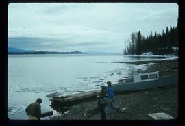
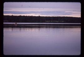
Image depicts two individuals on a canoe on Big Bar Lake north of Clinton, B.C..
Image depicts a large flock of ducks in a field full of water at an unknown location.
Image depicts a river at an uncertain location.
Image depicts the Fraser River, south of Soda Creek, B.C.
Image depicts the Fraser River, looking south from Marguerite, B.C.
Image depicts a farm on the west side of the Fraser, south of Quesnel, B.C.
Image depicts an old log cabin with the sign "Robin Hood Flour" on it at an uncertain location. It is possibly at the 153 Mile House.
Image depicts a scenic view of a section of land at an unknown location.
Image depicts what is likely a slump slide at an unknown location.
Image depicts a rail road bridge, possibly the Cottonwood Bridge, at an uncertain location.
Image depicts a view of a river from the Cottonwood Bridge.
Image depicts the Cottonwood Bridge.
Image depicts a sawmill somewhere in Quesnel, B.C.
Image depicts numerous wood piles near the sawmill somewhere in Quesnel, B.C.
Image depicts a sawmill somewhere in Quesnel, B.C.
Image depicts what appears to be a farm at an uncertain location.
Image depicts a river, possibly the Fraser, at an uncertain location.
Image depicts an unknown individual standing near what is most likely a slump slide at an uncertain location.
Image depicts an area of disturbed ground, most likely due to a landslide, at an unknown location.
Image depicts two unknown individuals standing near what is most likely a slump slide at an uncertain location.
Image depicts an area of placer mining at Hixon Creek in Hixon, B.C.
Image depicts a chasm full of trees at an unknown location.
Image depicts numerous buildings in Hendrix Lake, B.C.
Image depicts rail road tracks through a forest, as well as a river; located in Soda Creek, B.C.
Image depicts the old RCMP barn at 150 Mile House, B.C.
Image depicts the Flying U Ranch at 70 Mile House, B.C.
Image depicts several people standing near the Hixon Falls in Hixon, B.C.
Image depicts the Stellako River.
Image depicts a Fisherman wading in the Stellako River.
Image depicts the Bulkley River near Moricetown, B.C.
Image depicts a section of forest in the Bulkley Valley.
Image depicts the Bulkley River near Moricetown, B.C.
Image depicts numerous trees damaged by beavers near the Nautley River.
Image depicts two totem poles in Skeena Crossing, B.C.
Image depicts several unknown individuals on the shore of Babine Lake.
Image depicts a drill for blasting holes at a mine site somewhere in Granisle, B.C.
Image depicts numerous bags of blasting powder at a mine site somewhere in Granisle, B.C.
Image depicts the Fulton River.
Image depicts the mouth of the Kispiox River.
Image depicts the Bulkley River running through Moricetown Canyon.
Image depicts the Stellako River.
Image depicts an unknown individual with a raft on the Stellako River. The slide is labelled "fisheries research."
Image depicts an old house in Kispiox, B.C.
Image depicts a view of a lake that is near Telkwa, B.C. The slide is labelled as "Telkwa - McClure Lake," though it is possibly Tyhee Lake.
Image depicts the dock for ferries in Isle Pierre, B.C.
Image depicts the Battle Hill National Historic Site in Kitwanga, B.C.. The sign located there says: "The small knoll in the valley was a native fortress. Legends maintain that it was man-made: built to repel marauding coastal tribes. The hill was the scene of local tribal battles, and at one time was crowned with the defenders' buildings. Known as Dhawdezp, the unique mound is a prominent feature in the legends and history of the Indian people."