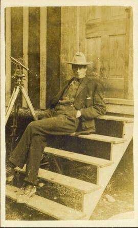
Affichage de 441 résultats

Archival description
190 résultats avec objets numériques Afficher les résultats avec des objets numériques
Bob Harkins interview with Walter Gill
2002.12.10 · Pièce · c.1970 - c.1989
Fait partie de Bob Harkins fonds

Item consists of interview with Walter Gill who discusses his career in the BC Provincial Police in Central Interior. Also talks about trapping in region.

Sans titre
Cunard Canadian services booklet
2009.5.4.57 · Pièce · [ca. 1920]
Fait partie de Taylor-Baxter Family Photograph Collection

This booklet, published by the Cunard Steam Ship Company, Ltd., provides an overview of Canada, England's emigration agents in Canada, and of the amenities provided by the Cunard Lines to its passengers immigrating to Canada from England via steamship. Booklet was printed in England.

2011.3.3.82 · Pièce · 1 July 1910
Fait partie de North Coast & Central BC Postcard Collection

Slightly elevated street view of buildings and sidewalks being constructed in Prince Rupert, BC. Printed annotation on recto reads: "Photo by McRae Bros. Third Ave Prince Rupert, BC." Handwritten annotation on verso reads: "Dear Florence you better [illegible] will try and answer it in a few day I am well I will try and send you some cards I will stay here till in Dec Write[??] me and send me some cards I am 15 mile in the mountains Write your Bro LS Bill." Postcard is addressed to: "Miss Florence Wilson P.O. Box 1178 Worcester Mass U.S.A." A 2 cent Canadian stamp is affixed on verso. Postmark reads: "Prince Rupert BC Jul 1 10."

The last big blast in Prince Rupert, BC
2011.3.3.85 · Pièce · 21 January 1914
Fait partie de North Coast & Central BC Postcard Collection

Photograph of a large explosion next to a huge pile of debris. Buildings are visible on either side and railroad track can be seen in the foreground. Printed annotation on recto reads: "The Last Big Blast, Prince Rupert BC 21 Jan 1914 McRae Bros. Photo"

First pile driven at Prince Rupert BC
2009.7.1.246 · Pièce · 8 June 1906
Fait partie de Archdeacon W. H. Collison fonds

Pile driver situated on Prince Rupert shoreline. Tents and wooden buildings visible on rocky background. Printed annotations on recto of photograph read: "First pile driven at Prince Rupert BC. June 8 '06."

After the blast 24 April 1913
2009.7.1.260 · Pièce · 24 April 1913
Fait partie de Archdeacon W. H. Collison fonds

Foreground shows a rocky shore covered in debris. A small crowd is visible along the coastline, and there are foggy outlines of hills beyond the water. Annotation on recto reads: "McRae Bros After the Blast 24th Apr. 13."

The last big blast 21 January 1914
2009.7.1.263 · Pièce · 21 January 1914
Fait partie de Archdeacon W. H. Collison fonds

Photograph of a large explosion next to a huge pile of debris. Buildings are visible on either side and railroad track can be seen in the foreground. Annotation on recto reads: "The Last Big Blast, Prince Rupert BC 21 Jan 1914 McRae Bros. Photo"

Moving mountains at Prince Rupert BC
2009.7.1.265 · Pièce · 24 April 1913
Fait partie de Archdeacon W. H. Collison fonds

Photograph of a large explosion on a rocky shoreline. A bridge is visible in the foreground and a body of water is partially visible in the background. Annotation on recto reads: "McRae Bros Moving Mountains at Prince Rupert BC Apr 24th"

First train leaving Prince Rupert
2009.7.1.266 · Pièce · 14 June 1911
Fait partie de Archdeacon W. H. Collison fonds

Photograph of a large crowd gathered in front of a Grand Trunk Pacific train. Residential buildings atop a hill are visible in the background. Annotation on recto reads: "First Train Leaving Prince Rupert June 14 1911"

2009.7.1.281 · Pièce · [ca. 1880-1920]
Fait partie de Archdeacon W. H. Collison fonds

Wide angle photograph of Prince Rupert sometime during the winter. There is snow on the ground and a marge mountain range is visible in the background. Annotation on recto reads: "Prince Rupert looking East from Waterworks J.D.A Pho 5/2."

2012.13.2.02.33.04 · Pièce · [1990?]
Fait partie de J. Kent Sedgwick fonds

The item is a reproduction of a survey map drafted in January 1910. The reproduction was likely created in 1990. The subdivision is Lot 936 G. I. Cariboo District, B.C. The area covered is North of Twenty First Avenue, East of Quinn Street, South of Eighth Avenue and West of Carney Street. Annotations highlight "Owner Edgar McMickiny," "696" and "Jordan Brothel" written in red pen pointing to a specific location.

2012.13.2.02.33.05 · Pièce · [1990?]
Fait partie de J. Kent Sedgwick fonds

The item is a reproduction of a survey map drafted in September 1909. The reproduction was likely created in 1990. The annotations highlight owners of different lots up to approximately 1959. Th area covered is North of Fifteenth Avenue, East of Irwin Street, South of Eighth Avenue and West of Carney Street. Annotations on attached papers indicate different means of scale and measurement for the map.

Pl. 721 DL 1426
2012.13.2.02.33.15 · Pièce · [1990?]
Fait partie de J. Kent Sedgwick fonds

The item is a reproduction of a survey map likely drafted in the 1910s. The reproduction was likely created in 1990. The area covered is South of Anderson Street, East of Simpson Street, North of Van Bien Avenue and West of 9th Street. Annotations state, "Pl 721 DL 1426."

2012.13.2.02.33.16 · Pièce · [1990?]
Fait partie de J. Kent Sedgwick fonds

The item is a reproduction of a survey map drafted on 1 March 1910. The reproduction was likely created in 1990. The area covered is South of Bernhardt Avenue, East of Simpson Street, North of the Fraser River and West of 9th Street. Annotations state, "DL 1426 Plan 721."

2020.05.15 · Pièce · [Sept. or Oct. 1936]
Fait partie de Gordon Wyness Album

Photograph depicts (from left to right) Gordon Wyness and Jack Lee at a camp scene "at Bobtail" (possibly Bobtail Lake) near Vanderhoof. As noted in the album caption, the crew had "just returned from Vanderhoof". The telegraph cabin roof and their 1930 Buick Series 40 car is visible at right.

Jack Lee rafting on Bobtail Lake
2020.05.17 · Pièce · [Sept. or Oct. 1936]
Fait partie de Gordon Wyness Album

Photograph depicts Jack Lee rafting with a sail on Bobtail Lake, as he was going over to other side of the lake to locate traverse posts (without success, according to the annotation on the photograph verso).

Lone Butte, BC
2020.05.22 · Pièce · Oct. 1936
Fait partie de Gordon Wyness Album

Photograph depicts a view of Lone Butte, BC. The butte formation of the same name (Lone Butte) is visible in the background; a ranch or residence is visible in the foreground. Wyness notes that Lone Butte was the "last one [they] tied in". "Tying in" is a land surveying technique. Since the photograph is dated October 1936 and Wyness described the survey trip as lasting June 5 - October 8, 1936, that implies that Lone Butte was the last location they surveyed on this trip.

View of Prince George from east hill
2020.05.25 · Pièce · [Sept. or Oct. 1936]
Fait partie de Gordon Wyness Album

Photograph depicts a view of the city of Prince George looking west from the east hill. The confluence of the Fraser River and Nechako River is visible to the right. The Grand Trunk Pacific Railway bridge is visible at centre. The current location of where this photograph may have been taken is likely somewhere near where Highway 16 rises on the hill past the correctional centre (jail).

Chasm
2020.05.48 · Pièce · 1936
Fait partie de Gordon Wyness Album

Photograph depicts "The Chasm" or "The Painted Chasm", located 11 miles north of Clinton, adjacent to the route of the Cariboo Road. In 1940, four years after this photograph was taken, Chasm Provincial Park was created in 1940 to preserve and promote the Painted Chasm feature, a gorge created from melting glacial waters eroding a lava plateau over a 10 million year span.

"Moran Dam Environmental Analysis"
2020.4.2.2.08 · Pièce · 1972
Fait partie de G. Gary Runka fonds

Item is an original copy of "Moran Dam Environmental Analysis" by the Cariboo Land Capability Analysis Committee and Intersector Special Study Committee of the British Columbia Canada Land Inventory. The committee members were A. Bedwany, D. Benn, D. Blower, R. Marshall, and G. Runka. Includes 24 original colour photographic prints pasted into the report.