1996.8.2
·
Série
·
1954-1967
Parte de Chander Suri fonds
2 resultados com objetos digitais
Mostrar resultados com objetos digitais
1996.8
·
Fundo
·
1954-2009
1996.8.2.01
·
Dossiê/Processo
·
1954
Parte de Chander Suri fonds
File consists of a preliminary study undertaken by the Lower Mainland Regional Planning Board of B.C. examining the growing metropolitan populaton of Greater Vancouver. Includes a report on the findings in member municipalites.
1996.8.2.11
·
Dossiê/Processo
·
[1956?]
Parte de Chander Suri fonds
File consists of a brief developed by the Lower Mainland Regional Planning Board of B.C. examining the problems with expanding urban sprawl in Greater Vancouver, outlining the findings of the research, and offering future suggestions.
1996.8.1.353
·
Item
·
September 1956
Parte de Chander Suri fonds
A b&w (photocopy) map of British Columbia Forest Service, Forest Surveys and Inventory Division index to the Interim Forest Cover Series and the Forest Inventory Area Reference System. Produced by the Department of Lands and Forests British Columbia.
1996.8.1.350
·
Item
·
1 July 1957
Parte de Chander Suri fonds
A b&w (photocopy) map of British Columbia Forest Service, Forest Surveys and Inventory Division index to the Interim Forest Cover Series and the Forest Inventory Area Reference System.
1996.8.1.351
·
Item
·
1 July 1957
Parte de Chander Suri fonds
A b&w (photocopy) map of British Columbia Forest Service, Forest Surveys and Inventory Division index to the Interim Forest Cover Series and the Forest Inventory Area Reference System.
1996.8.2.02
·
Dossiê/Processo
·
1959
Parte de Chander Suri fonds
File consists of a report by the Lower Mainland Regional Planning Board of B.C. outlining a continued program of housing research for the Greater Vancouver Area. The report examines similar experiences of other urban cities and outlines the proposed program for housing analysis.
1996.8.1.337
·
Item
·
1960, 1970 (?)
Parte de Chander Suri fonds
14 pieces of b&w (photocopy) papers most of which are unidentified tracings. The cellophane tape residues on the edges of the papers indicate that they used to be taped together. Plans could be related to Berman Lake, Nadsilnich Lake and Chief Lake. Produced by Fish and Wildlife Branch Department of Recreation and Conservation.
1996.8.2.03
·
Dossiê/Processo
·
1961
Parte de Chander Suri fonds
File consists of a report undertaken by the Lower Mainland Planning Board of B.C. forecasting the future of industrial land prospects. This report is part of a larger study of industrial settlement in the province.
1996.8.2.04
·
Dossiê/Processo
·
1961
Parte de Chander Suri fonds
File consists of a study examining the residential land structure of Metropolitan Vancouver. This study is supplementary to the Land for Living study. Includes one report of the findings and analysis of the study.
1996.8.3.06
·
Dossiê/Processo
·
1961-1971
Parte de Chander Suri fonds
File consists of annual district reports from 1969 and 1971 for the BC Department of Agriculture Development and Extension Branch detailing weather, crops, and season highlights. Includes a booklet on soil capability classifications and Central BC and Caribou agricultural census data for 1961-1966.
1996.8.1.392
·
Item
·
1961
Parte de Chander Suri fonds
A colour map illustrating the controur interval of a region in around Victoria B.C.
1996.8.2.05
·
Dossiê/Processo
·
1961
Parte de Chander Suri fonds
File consists of a report by the Lower Mainland Regional Planning Board of B.C. regarding the needs of industrial land. The report describes methods for carrying out these needs with suitable sites in the Lower Mainland area.
1996.8.3.05
·
Dossiê/Processo
·
1961
Parte de Chander Suri fonds
File consists of population data from the Regional District of Fraser-Fort George.
1996.8.2.06
·
Dossiê/Processo
·
1962
Parte de Chander Suri fonds
File consists of a report by the Lower Mainland Regional Planning Board of B.C. on the future industrial land prospects of the Lower Mainland.
1996.8.2.07
·
Dossiê/Processo
·
1962
Parte de Chander Suri fonds
File consists of a report by the Lower Mainland Regional Plannng Board of BC concerning availible farming land in the Lower Mainland.
1996.8.1.323
·
Item
·
1963
Parte de Chander Suri fonds
A b&w map illustrating subdivision of Prince George B.C.
1996.8.2.10
·
Dossiê/Processo
·
1963
Parte de Chander Suri fonds
File consists of a report by the Lower Mainland Regional Planning Board of B.C. regarding the facilities that serve households and standards of lower mainland dwelling facilities. The study correlates with a larger "Land for Living" report about land development in the Lower Mainland.
1996.8.1.325
·
Item
·
1963
Parte de Chander Suri fonds
A b&w map illustrating subdivision of a region in B.C. Fraser River is identified on the map.
1996.8.1.322
·
Item
·
1963
Parte de Chander Suri fonds
A b&w map illustrating subdivision of an region in BC. Nechako River, is identified on the map.
1996.8.1.324
·
Item
·
1963
Parte de Chander Suri fonds
A b&w map illustrating subdivision of region close to Prince George and areas in Northern B.C.
1996.8.2.08
·
Dossiê/Processo
·
1963
Parte de Chander Suri fonds
File consists of a report by the Lower Mainland Regional Plannng Board of BC concerning availible land in the Lower Mainland.
1996.8.2.09
·
Dossiê/Processo
·
1963
Parte de Chander Suri fonds
File consists of a study by the Lower Mainland Regional Planning Board of B.C. regarding the attitudes of residents in the Greater Vancouver fringe areas toward their environment. The study was part of the larger "Land for Living" report about land development in the Lower Mainland. Includes Part 1 and Part 2 of the report detailing survey structure, findings, and interpretation.
1996.8.3.07
·
Dossiê/Processo
·
1964-1967
Parte de Chander Suri fonds
File consists of assorted maps, correspondence, and speeches examining the prospects of park establishment in the Prince George area.
1996.8.1.021
·
Item
·
Feb 1964
Parte de Chander Suri fonds
6 plans produced by Briggs Greenwell Associates. 1581 4th Ave PG BC
1996.8.2.12
·
Dossiê/Processo
·
[between 1965 and 1967]
Parte de Chander Suri fonds
File consists of a petition by the Union of British Columbia Municipalities against the Amchitka Nuclear Test by the Atomic Energy Commission of the United States of America.
1996.8.1.186
·
Item
·
1965
Parte de Chander Suri fonds
This colour map is produced by the Army Survey Establishment, R.C.E. Copies may be obtained from the Map Distribution Office Department of Mines and Technical Survey, Ottawa.
1996.8.3.08
·
Dossiê/Processo
·
1965
Parte de Chander Suri fonds
File consists of a study by the Associated Engineering Services Ltd. on the metropolitan traffic of Prince George.
1996.8.3.09
·
Dossiê/Processo
·
1967
Parte de Chander Suri fonds
File consists of a bylaw for the City of Prince George to establish zoning. Includes a regional index of the Prince George area.
1996.8.1.439
·
Item
·
1967
Parte de Chander Suri fonds
A blueprint plan of subdivision of part of block 162, Seymour District. Esquimalt and Nanaimo Railway are identified on the plan.
1996.8.3.10
·
Dossiê/Processo
·
[1967?]
Parte de Chander Suri fonds
File consists of a plan to develop Pigeon Lake as a provincial park.
1996.8.1.355
·
Item
·
3 Oct 1967
Parte de Chander Suri fonds
A blueprint plan of the site plan of a house. Produced by Industrial Design and Drafting Service. Williams Cres. and Fraser River are identified on the plan.
1996.8.1.359
·
Item
·
16 Oct 1967
Parte de Chander Suri fonds
A blueprint plan of the section plan of a building. Produced by Industrial Design and Drafting Service.
1996.8.1.360
·
Item
·
16 Oct 1967
Parte de Chander Suri fonds
A blueprint plan of a building. Produced by Industrial Design and Drafting Service.
1996.8.1.022
·
Item
·
30 Oct 1967
Parte de Chander Suri fonds
4 Plans produced by Industiral Design and Drafting Service Prince George BC.
1996.8.3.01
·
Dossiê/Processo
·
[between 1968 and 1977]
Parte de Chander Suri fonds
File consists of multiple documents concerning the development of a master plan for the Regional District of Fraser-Fort George.
1996.8.3.03
·
Dossiê/Processo
·
1968
Parte de Chander Suri fonds
File consists of an appraisal by the Lower Mainland Regional Planning Board of the labour force and employment in Vancouver. This report is supplementary to other similar studies examining changes in the labour force.
1996.8.3.04
·
Dossiê/Processo
·
[between 1968 and 1977]
Parte de Chander Suri fonds
File consists of recreation reports, a Knothole zoning by-law article, public hearing agenda, and an industrial land use report, a number of reports on the zoning needs of small surrounding communities, a report on proposed rail routes to the NE of the province, a report on space requirements for downtown Prince George, a proposed study of water supply and sewage requirements in Prince George, a community analysis, statistics and information, presentation speeches on the tourism industry, and a report on the Hospital District in Fraser-Fort George.
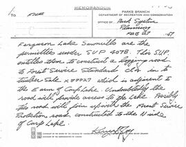
1996.8.3.14
·
Dossiê/Processo
·
1968
Parte de Chander Suri fonds
File consists of the preliminary outline of an urban pattern study by N. Pearson. Appended to the beginning of the report, members of the technical committee have laid out points of constructive critisicm about the drafted report. Includes a few pages of suggested edits and a drafted report on urban patterns.
1996.8.3.17
·
Dossiê/Processo
·
1968
Parte de Chander Suri fonds
File consists of a paper by the Lower Mainland Regional Planning Board of B.C. about the purchasing power of consumers in the Lower Mainland. The paper examines how rising income might affect urban living and possible responses.
1996.8.3.40
·
Dossiê/Processo
·
[between 1968 and 1977]
Parte de Chander Suri fonds
File consists of prospective planning material for the Regional District of Fraser Fort-George. Includes a recreation and tourism booklet, standardization of building code, technical planning committee documents, questionnaires, a community plan, a public lot draw document, and a study to increase secondary industry in the region.
1996.8.3
·
Série
·
1968-1977
Parte de Chander Suri fonds
1996.8.3.15
·
Dossiê/Processo
·
1968
Parte de Chander Suri fonds
File consists of a draft copy of an address by J.D. Mawell for delivery at the Sixth Annual Aministrator's Seminar for the BC Hospital's Association. The speech outlines aspirations for the Hospital Association in the future.
1996.8.3.02
·
Dossiê/Processo
·
[between 1968 and 1977]
Parte de Chander Suri fonds
File consists of an investment brochure for the City of Prince George.
1996.8.3.11
·
Dossiê/Processo
·
[1968-1971]
Parte de Chander Suri fonds
File consists of settlement planning documents for the Regional District of Fraser Fort-George. Includes planning pamphlets, handwritten notes, map sketches, tables regarding proportions of land in Agricultural Land Reserves, a report on the Prince George water supply, a list of directors 1968 Regional District Fraser-Fort George Board, and an index to published forest cover maps and data.
1996.8.3.12
·
Dossiê/Processo
·
1968
Parte de Chander Suri fonds
File consists of a speech titled "Secondary Industries" addressing the potential of industry expansion, specifically in Prince George.
1996.8.3.13
·
Dossiê/Processo
·
1968
Parte de Chander Suri fonds
File consists census data from the North West and Peace River regions between 1966 and 1968. Also includes population data from 1951, 1956, 1961, and 1966.
1996.8.3.16
·
Dossiê/Processo
·
1968
Parte de Chander Suri fonds
File consists of a paper by the Lower Mainland Regional Planning Board of B.C. about the economic growth in the Lower Mainland. The paper takes a national and provincial economic perspective to determine municipal action.
1996.8.1.445
·
Item
·
February 1968
Parte de Chander Suri fonds
Series of plans showing addition to Fraser Lake Elementary Secondary School: (1) Site Plan; (2) Floor & Roof Beams, Foundation Plan & Details; (3) Floor Plan, Schedules & Details; (4) Elevations & Sections; (5) Wall Sections; (6) Room Elevations & Cabinet Details.