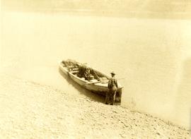
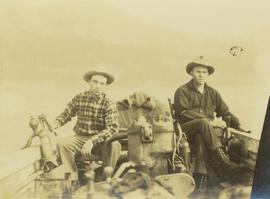
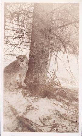
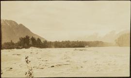
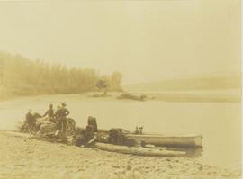
Print preview Close

Showing 4534 results

Archival description
3113 results with digital objects Show results with digital objects
Lunchroom Damaged by Boulder
2000.1.1.2.2.24 · Item · 1963
Part of Cassiar Asbestos Corporation Ltd. fonds

Handwritten caption beside this photo reads: "Lunchroom Damaged by Boulder". Large boulder stands to right of small building, walls of right corner partially destroyed. Lumber, upturned saw horse, and various other material lie on ground. Dirt road in foreground, mountainside in background.

Loos
2012.13.1.86.10 · Item · 1975
Part of J. Kent Sedgwick fonds

Image depicts several buildings in the community of Loos, B.C.

Loos
2012.13.1.86.09 · Item · 1975
Part of J. Kent Sedgwick fonds

Image depicts several buildings in the community of Loos, B.C.

Longworth - Railway Tracks
2012.13.1.87.031 · Item · [between 1975 and 1995]
Part of J. Kent Sedgwick fonds

Image depicts two unidentified individuals standing next to the train station, and two railway tracks running through Longworth, B.C.

2012.13.1.87.013 · Item · [between 1975 and 1995]
Part of J. Kent Sedgwick fonds

Image depicts a pile of old logs on the bank of the Fraser River with mountains in the background. In the foreground, a set of railway tracks run through an uncertain location, likely Upper Fraser, B.C.

Logs and Machinery
2012.13.1.87.056 · Item · [between 1975 and 1995]
Part of J. Kent Sedgwick fonds

Image depicts numerous piles of logs, and two unidentified individuals operating an excavator with a "thumb" attachment during the demolition of the Upper Fraser town site. Map coordinates 54°06'51.6"N 121°56'26.3"W

Logging
2012.13.1.122.12 · Item · 1977
Part of J. Kent Sedgwick fonds

Image depicts a logging area somewhere near Prince George, B.C.

Logging
2012.13.1.3.043 · Item · Nov. 1977
Part of J. Kent Sedgwick fonds

Image depicts an area undergoing logging somewhere in Prince George, B.C.

Logging
2012.13.1.122.13 · Item · 1977
Part of J. Kent Sedgwick fonds

Image depicts a logging area somewhere near Prince George, B.C.

2009.6.1.115 · Item · 3 January 1975
Part of The Honourable Iona Campagnolo fonds

Photograph depicts a forested mountain, the bottom half of which has been logged and terraced; beneath the mountain is a railroad track and parked vehickes including a schoolbus and two dumptrucks.

Handwritten annotation on verso reads: “Fairview Sodturning, Prince Rupert, 1/3/75”.

2019.10 · Collection · 1968-1970

These historically important aerial photographs depict Williston Lake soon after its creation in 1968 with the building of the W.A.C. Bennett Dam on the Peace River. Also depicted are the rivers and tributaries that empty into the Williston Reservoir, such as the Finlay River, the Ospika River, and the Omineca River.

These remote-sensing aerial photographs were taken by Lockwood Survey Corporation Ltd. under contract for the B.C. Forest Service. Some photographs are annotated to show logging activity; clearcuts, slash piles, log booms, and tree debris on the water are also visible in some of the images. No detailed location information or index accompanies the photographs.

Lockwood Survey Corporation Ltd.
2001.8.2.2.025 · File · 1983
Part of Geoffrey R. Weller fonds

File consists of a paper titled "Local Government in the Yukon and Northwest Territories" presented by Weller at the 1983 Western Social Science Association conference. This file was originally numbered to correspond with conference paper number 25 listed in Weller's CV.

2001.8.2.2.014 · File · 1980
Part of Geoffrey R. Weller fonds

File consists of a paper titled "Local Government in the Canadian Provincial North" presented by Weller at the 1980 Western Social Science Association conference. This file was originally numbered to correspond with conference paper number 14 listed in Weller's CV.

Loading up a pack horse
2000.19.2.154 · Item · 29 Aug. 1927-26 Sept. 1927
Part of Prentiss Gray Collection
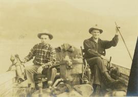
Photograph depicts a man loading up pack horse with two other laden pack horses visible in the periphery of the image.

Loading Pack Horses
2006.25.1.47 · Item · Oct. 1963
Part of Al Elsey Moving Images Collection

Footage of men preparing pack horses for a hunting trip in the early morning hours.

Possible locations of filming are Holt Homestead or Lassard Lake.

2006.25.1.76 · Item · Apr. 1966
Part of Al Elsey Moving Images Collection

Film begins with aerial footage of mountains believed to be around Bella Coola. Then recording of men loading barrels, supposedly of gas, into a boat using a "home made" winch and boom construction. They ferry the barrels up stream, the river is assumed to be Dean River. and use a similar construction to bring the barrels to shore.

There is also footage of men fishing in the river.