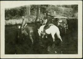
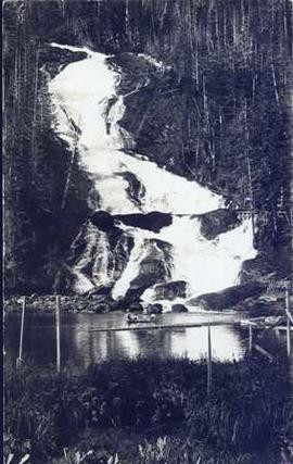
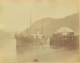
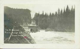
Showing 4134 results

Archival description
3619 results with digital objects Show results with digital objects
Three People, Three Dogs
2012.13.1.84.04 · Item · 1994
Part of J. Kent Sedgwick fonds

Image depicts three individuals and three dogs standing by a stream at an uncertain location, possibly somewhere in Bear Glacier Provincial Park. The woman in purple is possibly Sue Sedgwick.

Three People on a Beach
2012.13.1.67.02 · Item · 1979
Part of J. Kent Sedgwick fonds

Image depicts two individuals seated at a picnic table while a third stands closer to the water on a beach somewhere in Kitimat, B.C. What appears to be a harbour can be seen on the water.

Three Hikers
2012.13.1.65.15 · Item · May 1975
Part of J. Kent Sedgwick fonds

Image depicts a view of the scenery, with three hikers in the bottom left corner of the image.

Three diversion tunnels
2000.13.1.66 · Item · [between 1962 and 1967].
Part of Ray Williston fonds

Item is a photograph of the three tunnels built to divert the Peace River around the Bennett Dam construction site.

Three Children and Two Goats
2012.13.1.87.022 · Item · [between 1975 and 1995]
Part of J. Kent Sedgwick fonds

Image depicts three unidentified children standing in the doorway of a house, with two goats ascending the porch steps. The location is uncertain, likely Sinclair Mills, B.C.

2011.12.01 · Item · ca. 1950
Part of Giscome, BC Historical Photograph collection

Photo depicts a street perspective of Third Ave., in Prince George, BC, ca. 1950. Handwritten annotation in pen on verso of postcard reads: “You will undoubtedly notice that there are no tall buildings. I don’t think that there is one building in Prince George that is even five stories tall.”

The Tutshi
2012.13.1.98.06 · Item · 1999
Part of J. Kent Sedgwick fonds

Image depicts half of a ship, which is named the Tutshi, in Carcross, Y.T.

2012.13.2.19.29 · File · 1972
Part of J. Kent Sedgwick fonds

File consists of a pamphlet titled "The Quesnel-Lillooet Bulletin Area" prepared by the Department of Lands, Forests, and Water Resources from the Province of British Columbia. The pamphlet is a revised 2nd edition published in 1973, the original was published in 1968.

2011.3.4.15 · Item · 24 December 1915
Part of North Coast & Central BC Postcard Collection

Stern wheeler “Port Simpson” tied to riverbank. Printed annotation on recto reads: “On the Skeena river, Hazelton, B.C.” Handwritten message on verso is addressed to “Mrs. Flossie Strong 6 Nah St. Watermill ME, U.S.A” 1 cent Canadian postage stamp has been canceled with a date of “Dec 24, 5:30 PM 1915 Buffalo N.Y.”

2009.7.1.263 · Item · 21 January 1914
Part of Archdeacon W. H. Collison fonds

Photograph of a large explosion next to a huge pile of debris. Buildings are visible on either side and railroad track can be seen in the foreground. Annotation on recto reads: "The Last Big Blast, Prince Rupert BC 21 Jan 1914 McRae Bros. Photo"

The Duke of Connaught
2012.13.2.02.37 · File · 2001-2007
Part of J. Kent Sedgwick fonds

File consists of notes and reproductions relating to Prince Arthur the Duke of Connaught, the third son of Queen Victoria who took the place of Governor General in Canada in 1911. Connaught Hill in Prince George was named in rememberance after Prince Arthur. File predominantly consists of printed websites and newspaper articles describing Prince Arthur, the Duke of Connaught, and his role as Governor General.

The Bullion Pit
2012.13.1.69.25 · Item · [1981?]
Part of J. Kent Sedgwick fonds

Image depicts the Bullion Pit in Likely, B.C. It is a man-made canyon from the days of the gold-rush, formed by the use of hydraulic monitors. The gold-mine operated from 1892 to 1942.

The Bourchier Album
2009.5.3 · File · [ca. 1895 - 1950]
Part of Taylor-Baxter Family Photograph Collection

This photograph album consists of photographs of remote police barracks at Mile 47 and Mile 29; early settlements and/or mercantile stores at Tete Jaune Cache, McBride, Sand Creek, Fort George and South Fort George; Grand Trunk Pacific Railway forestry and railway camps; scows and paddlewheel conveyors on the Fraser River; automobiles; community leisure activities; as well as, images of the Bourchier family. The following South Fort George establishments are identifiable within these photographs: Empress Hotel, Ah Yee General Merchant, German Bakery, Northern Hotel, South Fort George Drug Store & Post Office, St. Michael’s Church, Prince George Hotel, Ford Monarch dealership, Astoria Hotel, and King George V Elementary School. Identified geographic locations featured in these photographs include: Tete Jaune, Upper Fraser, Mile 47, Mile 29, Fraser River, Mt. Robson, McBride, Sand Creek, Glacier Mountain, Moose River, Giscome Portage, Pott Falls, Red Deer River, Grand Canyon, Summit Lake, Canoe Pass, Connaught Hill, Nechako Bridge, and Island Cache.

Bourchier, Alan K.
Tete Jaune
2012.13.2.17.32 · File · 1980-1994
Part of J. Kent Sedgwick fonds

File consists of notes, clippings, and reproductions relating to Tete Jaune.

Terzaghi Dam
2012.13.1.59.22 · Item · July 1980
Part of J. Kent Sedgwick fonds

Image depicts the Terzaghi Dam viewed from the downstream side near Bralorne B.C.