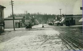
Geographic Features

Elements area

Taxonomy

Code

Scope note(s)

  • Includes both natural and artificial features
  • Physical landscape, built landscape
  • Urban and industrial landscapes
  • Topography
  • Site plans
  • Boundaries, districts, reserves, parks, sanctuaries, towns, etc.
  • NOTE: Mainly but not exclusively pertaining to photographic and cartographic records
  • SEE ALSO: Land, Settlement and Immigration

Source note(s)

  • MemoryBC Subject Groups

Display note(s)

    Hierarchical terms

    Geographic Features

      Equivalent terms

      Geographic Features

        Associated terms

        Geographic Features

          4134 Archival description results for Geographic Features

          4134 results directly related Exclude narrower terms
          Forest in Bangladesh
          2000.13.1.83 · Item · 1973.
          Part of Ray Williston fonds

          Item is a photograph of a forested area southwest of Chittagong, Bangladesh close to the border with Burma.

          Coffer dam
          2000.13.1.67 · Item · [between 1962 and 1967].
          Part of Ray Williston fonds

          Item is a photograph of the coffer dam built to isolate the construction site for the W.A.C. Bennett Dam.

          Three diversion tunnels
          2000.13.1.66 · Item · [between 1962 and 1967].
          Part of Ray Williston fonds

          Item is a photograph of the three tunnels built to divert the Peace River around the Bennett Dam construction site.

          2000.13.1.65 · Item · [between 1962 and 1967].
          Part of Ray Williston fonds

          Item is a photograph of the construction of a temporary river bed to divert the Peace River during construction of the W.A.C. Bennett Dam.

          2000.13.1.63 · Item · [between 1962 and 1967].
          Part of Ray Williston fonds

          Item is a photograph of the diversion tunnel as engineers plan to blast the plug to allow the Peace River to be diverted for construction of the W.A.C. Bennett Dam.

          2008.3.1.22.36 · Item · [ca. 1995]
          Part of Bridget Moran fonds

          Photograph depicts sign in foreground outlining rules and restrictions for behaviour at Moricetown Canyon. Traditional fishing territory visible behind sign at waterfall in the Bulkley River, B.C. Highway and buildings can be seen in background.