Geographic Features

Elements area

Taxonomy

Code

Scope note(s)

  • Includes both natural and artificial features
  • Physical landscape, built landscape
  • Urban and industrial landscapes
  • Topography
  • Site plans
  • Boundaries, districts, reserves, parks, sanctuaries, towns, etc.
  • NOTE: Mainly but not exclusively pertaining to photographic and cartographic records
  • SEE ALSO: Land, Settlement and Immigration

Source note(s)

  • MemoryBC Subject Groups

Display note(s)

    Hierarchical terms

    Geographic Features

      Equivalent terms

      Geographic Features

        Associated terms

        Geographic Features

          4134 Archival description results for Geographic Features

          4134 results directly related Exclude narrower terms
          Atlin Lake
          2012.13.1.98.14 · Item · 1999
          Part of J. Kent Sedgwick fonds

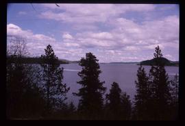
          Image depicts Atlin Lake as well as a small section of Atlin, B.C. The mountain is possibly Atlin Mountain.

          White Pass Train
          2012.13.1.100 · Subseries · 1999
          Part of J. Kent Sedgwick fonds

          File contains slides depicting locations along the White Pass railway through Alaska, British Columbia, and the Yukon Territories.

          Forested Mountains
          2012.13.1.100.06 · Item · 1999
          Part of J. Kent Sedgwick fonds

          Image depicts a view of a forested, mountainous area and a river, somewhere along the White Pass railway. The slide is labelled "begin climb," suggesting the image was taken at the beginning of the White Pass Train's ascent into the mountains.

          Stream
          2012.13.1.100.07 · Item · 1999
          Part of J. Kent Sedgwick fonds

          Image depicts a stream somewhere along the White Pass railway.

          Forested Valley
          2012.13.1.100.08 · Item · 1999
          Part of J. Kent Sedgwick fonds

          Image depicts a view of a forested valley in the mountains somewhere along the White Pass railway.

          Forest and River
          2012.13.1.100.09 · Item · 1999
          Part of J. Kent Sedgwick fonds

          Image depicts a view of a forest and river somewhere along the White Pass railway. The thin line in the mountain side is possibly a highway.

          Another Train
          2012.13.1.100.14 · Item · 1999
          Part of J. Kent Sedgwick fonds

          Image depicts another train on the White Pass railway along a forested mountain side.

          Tunnel
          2012.13.1.100.15 · Item · 1999
          Part of J. Kent Sedgwick fonds

          Image depicts the White Pass Train entering a tunnel in the mountain side.

          Trail of 98
          2012.13.1.100.20 · Item · 1999
          Part of J. Kent Sedgwick fonds

          Image depicts a patch of snow-covered ground with a sign that reads "Trail of 98," somewhere along the White Pass railway.

          Tsilcoh Falls
          2012.13.1.51.147 · Item · 1999
          Part of J. Kent Sedgwick fonds

          Image depicts the Tsilcoh Falls, north of Fort St. James and somewhere near Pinchi Lake Road.

          Willow River - Playground
          2012.13.1.89.139 · Item · 1999
          Part of J. Kent Sedgwick fonds

          Image depicts a playground in Willow River, B.C. The slide labels it as being a "former hotel site." Map coordinates 54°04'23.7"N 122°28'26.9"W

          Atlin - the Tarahne
          2012.13.1.98.29 · Item · 1999
          Part of J. Kent Sedgwick fonds

          Image depicts a boat named "the Tarahne," which is located in Atlin, B.C. Atlin Lake and Mountain are visible in the background.

          Atlin - A Dock
          2012.13.1.98.31 · Item · 1999
          Part of J. Kent Sedgwick fonds

          Image depicts a dock on the shore of Atlin Lake, as well as a building that may have once been a hospital. The slide is simply labelled "hospital."

          Atlin - the Tarahne
          2012.13.1.98.32 · Item · 1999
          Part of J. Kent Sedgwick fonds

          Image depicts a boat named "the Tarahne," which is located in Atlin, B.C. Atlin Lake and Mountain are visible in the background.

          Alaska Highway
          2012.13.1.98.59 · Item · 1999
          Part of J. Kent Sedgwick fonds

          Image depicts a small section of the Alaska Highway somewhere near Whitehorse, Y.T. The slide also appears to be labelled "army washing" for unknown reasons.

          Eroding Rock Face?
          2012.13.1.98.60 · Item · 1999
          Part of J. Kent Sedgwick fonds

          Image depicts what appears to be an eroding rock face. The slide itself is labelled "ash loger at top" for unknown reasons. Possibly located somewhere near Whitehorse, Y.T.

          Forested Mountain Side
          2012.13.1.100.10 · Item · 1999
          Part of J. Kent Sedgwick fonds

          Image depicts a forested mountain side somewhere along the White Pass railway. The thin ridge along the mountain side is possibly either a highway or part of the railway.

          White Pass - Mountain Side
          2012.13.1.100.12 · Item · 1999
          Part of J. Kent Sedgwick fonds

          Image depicts a mountain side somewhere along the White Pass railway. The thin ridge along the mountain side is possibly either a highway or part of the railway.

          2012.13.2.17.02 · File · 1999-2008
          Part of J. Kent Sedgwick fonds

          File consists of notes, clippings, and reproductions relating to research of the Upper Fraser as part of the UNBC Upper Fraser Historical Geography Project. Includes photographs depicting students and professors researching in the Upper Fraser region (Dec. 1999).

          Tsilcoh Falls
          2012.13.1.51.148 · Item · 1999
          Part of J. Kent Sedgwick fonds

          Image depicts the Tsilcoh Falls, north of Fort St. James and somewhere near Pinchi Lake Road.

          Nautley
          2012.13.1.51.157 · Item · [1999?]
          Part of J. Kent Sedgwick fonds

          Image depicts Nautley and the Nautley River near Fraser Lake, B.C.

          Kenny Dam
          2012.13.1.51.164 · Item · [1999?]
          Part of J. Kent Sedgwick fonds

          Image depicts Kenny Dam, south of Francois Lake, and southwest of Vanderhoof, B.C.

          2012.13.4.08 · File · 1999-2000
          Part of J. Kent Sedgwick fonds

          File consists of photographs depicting the Salmon River Portage. Includes depictions of potential past mill sites, overgrown fields, and derelict buildings.

          Nautley
          2012.13.1.51.158 · Item · [1999?]
          Part of J. Kent Sedgwick fonds

          Image depicts Nautley and the Nautley River near Fraser Lake, B.C.

          Kenny Dam
          2012.13.1.51.163 · Item · [1999?]
          Part of J. Kent Sedgwick fonds

          Image depicts a stretch of land; the photo was taken from the top of Kenny Dam, south of Francois Lake.