McBride, BC

Elements area

Taxonomy

Code

Scope note(s)

    Source note(s)

      Display note(s)

        Hierarchical terms

        McBride, BC

          Equivalent terms

          McBride, BC

            Associated terms

            McBride, BC

              40 Archival description results for McBride, BC

              40 results directly related Exclude narrower terms
              Elks Flag Day, McBride, BC
              2011.3.1.15 · Item · 5 January 1945
              Part of North Coast & Central BC Postcard Collection

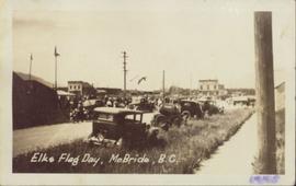
              Photograph of several vehicles parked along a road. A large crowd is visible gathering in the background. Printed annotation on recto reads: "Elks Flag Day, McBride, B.C." Handwritten annotation on verso reads: "Jan. 5th 1945. Dear Dad, Am working in a lumber camp, advised by Prof. Johnson and Prof Casey. Altitude about 2,300. Think I will like it, if they don't make me work to[sic] heavy. the Climate and the grub is swell. Otherwise not so hot. Bye for now. Love Will." Postcard is addressed: "To: Mr. A.W. Hockin Big Valley, Alberta. From. W. Hockin c/o E.U. Lamming McBride, B.C."

              McBride - Church
              2012.13.1.85.62 · Item · [2004?]
              Part of J. Kent Sedgwick fonds

              Image depicts a church somewhere in McBride, B.C. The sign in front possibly reads "St. Patrick's Church."

              McBride - Yellowhead
              2012.13.1.085 · Subseries · [between 1970 and 2004]
              Part of J. Kent Sedgwick fonds

              File contains slides depicting places in and between McBride and the Yellowhead Pass via the Yellowhead Highway.

              McBride, BC in 1914
              2009.5.3.57 · Item · 1914
              Part of Taylor-Baxter Family Photograph Collection

              Photograph depicts street in McBride, wood buildings and tent buildings on either side. Small businesses and restaurants line the left side of the street. Forest slash stands in newly cleared area in foreground. Railway tracks cross right foreground, hills visible in background. Annotation on verso of photograph reads: "MC.Bride, B.C.", handwritten on recto: "1914 [Bourchier?]"

              Near McBride
              2012.13.1.85.08 · Item · 1976
              Part of J. Kent Sedgwick fonds

              Image depicts a view of either the Rocky Mountains or possibly the Columbia Mountains near McBride, B.C.

              Ranch of the Vikings
              2012.13.1.85.32 · Item · [1978?]
              Part of J. Kent Sedgwick fonds

              Image depicts the ranch house of the Ranch of the Vikings, originally owned and operated by Bjorger Pettersen, a member of the Canadian Ski Hall of Fame, from 1970 until 1985. It is located somewhere west of McBride, B.C.

              The Bourchier Album
              2009.5.3 · File · [ca. 1895 - 1950]
              Part of Taylor-Baxter Family Photograph Collection

              This photograph album consists of photographs of remote police barracks at Mile 47 and Mile 29; early settlements and/or mercantile stores at Tete Jaune Cache, McBride, Sand Creek, Fort George and South Fort George; Grand Trunk Pacific Railway forestry and railway camps; scows and paddlewheel conveyors on the Fraser River; automobiles; community leisure activities; as well as, images of the Bourchier family. The following South Fort George establishments are identifiable within these photographs: Empress Hotel, Ah Yee General Merchant, German Bakery, Northern Hotel, South Fort George Drug Store & Post Office, St. Michael’s Church, Prince George Hotel, Ford Monarch dealership, Astoria Hotel, and King George V Elementary School. Identified geographic locations featured in these photographs include: Tete Jaune, Upper Fraser, Mile 47, Mile 29, Fraser River, Mt. Robson, McBride, Sand Creek, Glacier Mountain, Moose River, Giscome Portage, Pott Falls, Red Deer River, Grand Canyon, Summit Lake, Canoe Pass, Connaught Hill, Nechako Bridge, and Island Cache.

              Bourchier, Alan K.