2024.2
·
Collectie
·
1997-2002
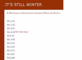
This collection encompasses the records of the eJournal "It's Still Winter: A Web Journal of Contemporary Canadian Poetry and Poetics", which was co-published online by College of New Caledonia and the University of Northern British Columbia between 1997 and 2002. The editors of the journal were Don Precosky and Barry McKinnon. The journal published the work of poets from across Canada, but the majority were from northern British Columbia.
The collection contains analogue reproductions of the eJournal issues, drafts and manuscript submissions to the eJournal, and digital records relating to the eJournal (including the website files for the online eJournal).