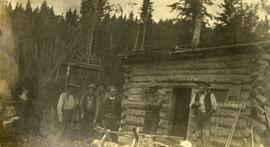
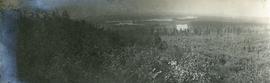
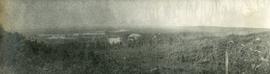
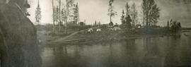
Aerial photograph depicts a view overlooking the Georges farm. Note on back stated that this photograph was presented in a frame to the Georges in 2008.
Item is a photograph of Alex Moffat dressed as a prospector holding gold nuggets he salted into a gravel bed and later panned out and gave to Princess Margaret.
Slide depicts the original wooden BC Forest Service sign for the Aleza Lake Forest Experiment Station.
Photograph depicts a view of the river shore, a few scattered buildings and tents are near the shore. A footpath leads from the water's edge between the dwellings and through the newly cleared land.
Photograph depicts twenty-eight or more people standing on the river's edge, a stack of wood is ready for loading on the steamer that is anchored near the shore.
Slide depicts a black bear eating garbage by wooden outbuildings, possibly at the Aleza Lake Experiment Station.
Slide depicts a bulldozer clearing ground, likely at the Aleza Lake Experiment Station.
Photograph depicts several canvas tents set in lush vegetation near dusk.
Photograph depicts a view from the river looking at the river bank. There is a canvas tent with forest in the background.
Photograph depicts four men paddling a long canoe. The canoe is loaded with supplies and a dog, river and forest in the background.
Photograph depicts six men standing outside a small log building. A sawhorse in the foreground, a tall pole "cache" and forest in the background.
Photographs are panoramas taken from the Churchill BC Forest Service Lookout, located at latitude 54°04' and longitude 122°16'. The photographs were bound together and include a transparent grid that was intended to be used for locating forest fires.
Slide depicts a cleared area at the Aleza Lake Experiment Station with plant regeneration.
Slide depicts a cleared area in a forest, likely at the Aleza Lake Experiment Station.
Slide depicts a detonation in an area of cleared ground in a forested area, likely the Aleza Lake Experiment Station. Work may have been undertaken for roadbuilding activities at the Experiment Station.
Photograph depicts four men pulling a long canoe across a clearing on a wheeled trailer.
Photograph depicts a tarp spread out on the grass, two men sit nearby the tarp. There is a canvas tent in the background with a man standing beside it. Behind the tent is a low hill with a fence bordering the top of the hill. There are blankets drying on the fence.
Series consists of records reflecting the activities of the Dezell and Rustad families. Series include mayoral records from Bea and Garvin Dezell when Garvin served as Mayor of Prince George. Series includes materials celebrating Bea Dezell's life created by her family. Series also includes fundraising efforts for the Northern Medical Programs Trust. Finally, series includes a collection of "spruce" dollars and commemorative coins.
Photograph depicts several people in a large field. There are buildings and trees in the background.
Slide depicts a heavily forested area with fallen logs, likely at the Aleza Lake Experiment Station.
Photograph depicts four men pinning a "Union Jack" flag to the exterior of a building.
Photograph depicts view of the river from a boat. There is a silhouette of a person wearing a hat in the foreground.
Photograph depicts a wide expanse of river in the foreground looking across the water to a narrow clearing along the opposite riverbank. A few building are scattered across the clearing. There is forest in the background.
Photograph depicts a view from a hill of a river winding through the forest with marshlands nearby.
Photograph depicts a view from a hill of a river winding through the forest with marshlands nearby. This may be a double exposure and there is an indiscernible image in the center of the photo.
Photograph depicts Harry Coates, Ted Baker, and John Revel at Aleza Lake Research Forest re-opening ceremony on July 9, 1992.
Photograph depicts nine or more people watching a steamer navigate the rough waters of Fort George Canyon from the river shore.
Photograph depicts the rough waters and rocks at Fort George Canyon.
Slide depicts a man operating heavy equipment in a forest, likely at the Aleza Lake Experiment Station.
Photograph depicts a large white building surrounded by a fence.
Image depicts the Lakeland Sawmill in Prince George, B.C, identified by the beehive burners; the one with white smoke belonged to Pas Lumber Co. which was bought out by Lakeland in 1987.
Image depicts the Lakeland Sawmill in Prince George, B.C.
Photograph depicts one man standing on the bank of a river, forest in the background. The image is not in focus or possibly a double exposure.
Photograph depicts a cluster of wooden buildings including a flagpole and church spire at a Lheidli T'enneh village site. Original photo identified this image as "Indian Village, Fort George".
Image depicts an area undergoing logging somewhere in Prince George, B.C.
Photograph depicts a man bathing himself while standing in a small metal tub. Photograph description in album notes this as "His 'Semi Annual'" [bath]. On the left is a log structure, presumably a cache building. A large clearing surrounds the building and bathing man. There is a forest and bluff in the background. Possibly located near Giscome Portage.
Photograph depicts a view from a high hill, looking down on the Nechako river. There is forest and low rolling hills in the background.
Photograph depicts a view from a high hill looking down on the Nechako river. There is forest and low rolling hills in the background.
Photograph depicts eighteen or more canvas tents scattered on the river shore next to rough cabins and an outhouse.
Image depicts the Northwood pulpmill in Prince George B.C.
Image depicts the Northwood Pulpmill in Prince George, B.C. taken from above the Nechako River looking east. Map coordinates 53°56'00.0"N 122°44'29.7"W
Image depicts the Northwood pulpmill in Prince George B.C.
Photograph depicts several men standing on the river bank. Possibly A.H. Holland in center of photo.
Series consists of photographs created or accumulated by the Aleza Lake Research Forest Society.
Image depicts Prince George, possibly with the Northwood Pulpmill in the background.
Image depicts the Prince George Sawmill from the Northwood Bridge.
Image depicts Prince George Sawmill taken from across the Nechako River looking southwest. Map coordinates 53°56'00.0"N 122°44'29.7"W