Reproduced map on mylar depicts locations of elevations and benchmarks at the Aleza Lake forest.
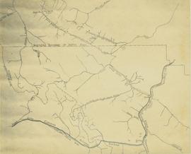
Map depicts the rivers, railways, and select lakes and towns located at Jasper Park between the northern boundary of the park and the townsite of Jasper. Part of the border between Alberta and British Columbia is visible on the west of the map.
Reproduced map on mylar depicts a proposed railway spur for the Aleza Lake Forest Experiment Station.
Reproduced map on mylar depicts the Aleza Lake timber reserve near Aleza Lake, BC.
Map of Timber Sale X9696 shows the area for the TSX with spruce balsam timber. Location is 4 miles from the Myra Station of the Kettle Valley Railway.
Map of Timber Sale X9696 shows the area for the TSX with the location of plots, roads, traverse posts, and the Forest Branch cabin. Location is 4 miles from the Myra Station of the Kettle Valley Railway.
Map of Timber Sale X9696 shows topography for the area. Location is 4 miles from the Myra Station of the Kettle Valley Railway.
Map of Timber Sale X9696 shows topography for the area. Location is 4 miles from the Myra Station of the Kettle Valley Railway.
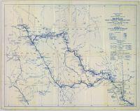
Item is a preliminary plan showing traveled route of the Bedaux Sub-Arctic Expedition in 1934.
Original forest cover map shows timber history in the area of Giscome, BC.
Map is a mylar reproduction of an Aleza Lake Forest Reserve map.
Map reflects reserve boundary, roads, trails, 20 feet contour intervals, air photo centre, declination, swamps, and mile post at the Aleza Lake Forest Reserve.
Map is an uncontrolled mosaic of aerial photography of the Aleza Lake Research Forest, with a July 1955 date of the air photography. Duplicate exists.
Map of Timber Sale X72108 shows area to be scarified, as well as previously logged areas. Location is outside Prince George in the Upper Fraser area near Kenneth Creek.
Map of Timber Sale X72108 shows area to be scarified. Location is outside Prince George in the Upper Fraser area near Kenneth Creek.
Map of Timber Sale X72108 shows area to be scarified. Location is outside Prince George in the Upper Fraser area near Kenneth Creek.
Logging plan of Sinclair Spruce Lumber Company's T.S.X. 73378 at Hubble Creek shows areas to be cut.
Logging plan of Sinclair Spruce Lumber Company's T.S.X. 73378 at Hubble Creek shows areas to be cut. Annotations show areas logged.
Map is a photocopy reproduction of the Aleza Lake Experiment Forest working circle timber sale map that was included in the appendix to the 1957 Aleza working plan.
Map is a photocopy reproduction of the Aleza Lake Experiment Forest development map that was included in the appendix to the 1957 Aleza working plan.
Map is a photocopy reproduction of the Aleza Lake Experiment Forest permanent plot map that was included in the appendix to the 1957 Aleza working plan.
Map is a photocopy reproduction of the Aleza Lake Experiment Forest map that was included in the appendix to the 1957 Aleza working plan.
Map is a photocopy reproduction of the "Aleza Lake Experiment Forest" map that was included in the appendix to the 1957 Aleza working plan.
Map reflects reserve boundary, roads, trails, 20 feet contour intervals, air photo centre, declination, swamps, and mile post at the Aleza Lake Forest Reserve.
Map reflects reserve boundary, roads, trails, 20 feet contour intervals, air photo centre, declination, swamps, and mile post at the Aleza Lake Experiment Forest.
Map reflects reserve boundary, roads, trails, 20 feet contour intervals, air photo centre, declination, swamps, and mile post at the Aleza Lake Experiment Forest.
Map reflects reserve boundary, roads, trails, 20 feet contour intervals, air photo centre, declination, swamps, and mile post at the Aleza Lake Experiment Forest.
Map reflects lot and STL lines, timber sale boundaries, Highway 16, roads, beetle infested areas, and plots X91971 to X91980, and X89946.
This very large drawing shows CN leases and private property buildings on Island Cache in detail.
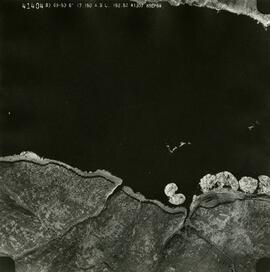
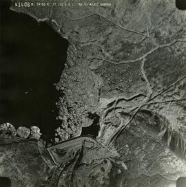
Lockwood Survey Corporation Ltd.This remote-sensing aerial photograph was taken by Lockwood Survey Corporation Ltd. under contract for the B.C. Forest Service. This historically important aerial photograph depicts the headwaters of Williston Reservoir soon after its creation in 1968 with the building of the W.A.C. Bennett Dam on the Peace River.
The identification coding on these photographs can be interpreted as follows:
- The largest number on the leftmost side is the frame number for the photograph.
- The following code to the right in the format B) 69-53 is currently unknown, but may refer to an internal project number for the Lockwood Survey Corporation.
- The 6" may refer to the camera's focal length in inches.
- Next is "17,150 ASL" which is 17,150 feet Above Sea Level.
- Following is "152.52" which refers to the camera's focal length in millimeters, which equals 6 inches.
- The "W1307" may refer to the reel, but that is unconfirmed.
- "8 SEP 69" is the date the photo was taken.
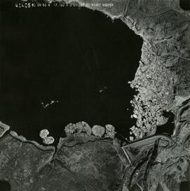
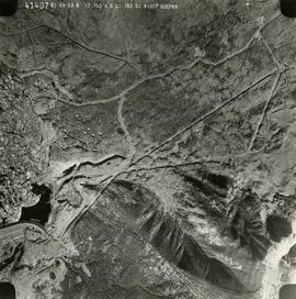
This remote-sensing aerial photograph was taken by Lockwood Survey Corporation Ltd. under contract for the B.C. Forest Service. This historically important aerial photograph depicts the W.A.C. Bennett Dam and Williston Reservoir soon after its flooding in 1968.
The identification coding on these photographs can be interpreted as follows:
- The largest number on the leftmost side is the frame number for the photograph.
- The following code to the right in the format B) 69-53 is currently unknown, but may refer to an internal project number for the Lockwood Survey Corporation.
- The 6" may refer to the camera's focal length in inches.
- Next is "17,150 ASL" which is 17,150 feet Above Sea Level.
- Following is "152.52" which refers to the camera's focal length in millimeters, which equals 6 inches.
- The "W1307" may refer to the reel, but that is unconfirmed.
- "8 SEP 69" is the date the photo was taken.
Map reproduction of the Aleza Lake Research Forest depicts timber sale areas, forest cover, and other details.
Map reproduction of the Sinclair Spruce Lumber Co. Ltd. T.S.H.L. A01848 C.P. 310 cutting area, likely in the Aleza Lake Research Forest.
Map reflects soil and landforms of Giscome area.
Item is a hand drawn and coloured map by the City of Prince George Planning Department depicting zoning proposed by the Prince George City Planner for the VLA neighbourhood.
Item is a hand drawn and coloured map by the City of Prince George Planning Department depicting Hart Highway neighbourhood area existing land use in 1976.
City of Prince GeorgeItem is a hand drawn and coloured map by the City of Prince George Planning Department depicting the Blackburn neighbourhood development area's proposed sector plan in 1976.
Item is a hand drawn and coloured map by the City of Prince George Planning Department depicting the VLA neighbourhood proposed zoning in 1976.
Item is a hand drawn and coloured map by the City of Prince George Planning Department depicting public representations at the VLA neighbourhood zoning hearing that occurred on April 12, 1976.
Item is a hand drawn and coloured map by the City of Prince George Planning Department depicting zoning proposed by Prince George Alderman A. Stauble for the VLA neighbourhood.
Item is a hand drawn and coloured map by the City of Prince George Planning Department depicting the North Nechako and Hart neighbourhood area proposed land use in 1976.

