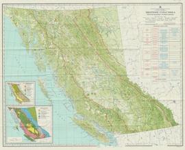
Item is a map compiled and produced by Geographic Division, Surveys and Mapping Branch, Department of Lands, Forests, and Water Resources ; geological and physiographical data supplied by Dept. of Mines and Petroleum Resources, Victoria, B.C. (1964).
Government map depicts railway lands, lands "disposed of", grazing leases, and timber berths. Shows the British Columbia 'railway belt' running from Greater Vancouver to Field, B.C.
Map depicts railways in British Columbia, with insets for the Lower Mainland and the Kootenays.
Item is an original 1968 map depicting British Columbia and its reliefs, including hills, valleys, and mountains across the province. The map was published by the British Columbia Department of Lands, Forests and Water Resources.
Map depicts the Coast of British Columbia and Federal and Provincial proposed fishing boundaries, including the 200 mile limit.
Map depicts to Canadian federal electoral districts for the 1993 federal election.
Map depicts the jurisdictions of the various Indian treaties in existence in 1966, including the boundaries of: no surrenders, exempted-royal proclamation, no valid surrenders, land and hunting rights surrenders, and land surrender only. The whole of Canada is depicted in this map.
Map depicts Canadian railways in operation at 2011.
Map depicts the shipping highway routes across Canada. Primary, secondary, and access routes are noted as-well as proposed routes.
Map depicts the Canadian National Railway system, including trackage for the Central Vermont Railway, the Detroit & Toledo Shore Line Railroad, the Grand Trunk Western Railroad, the Duluth Winnipeg & Pacific Railway, and the Northern Alberta Railway.
Map depicts the CNR system in Canada and the United States and all of its connecting lines, including the Central Vermont Railway, the Grand Trunk Western Railroad, and the Duluth Winnipeg & Pacific Railway.
The Canadian National Railway series consists of administrative records, safety records, correspondence between departments, labour records, records pertaining to train movements, maintenance records, and ephemera. Includes publications concerning the topics of unionized labour, railway operation, maintenance of way, handling of hazardous materials, safety, public interest, and the two Royal Tours of 1939 and 1959. Also consists of maps and technical drawings depicting Canadian National Rail lines and equipment.
Canadian National RailwayThe item is a map that depicts Canadian National Railway plans along Hammond street and the Fraser River. Includes the railway property, private property, proposed streets, and government owned property in the Prince George area.
Map depicts passenger routes on the Canadian Pacific Railway and its connecting lines in 1925.
Map issued as part of the Canadian Pulp and Paper Industry magazine. Depicts locations of all pulp and paper mills in Canada in 1975 and provides a listing of company names.
Zimmerman, AdamFile consists notes, correspondence, summary reports, inventory data, and a map regarding capability classification for Bowser Lake. The map is a "clean copy" of Grant Hazelwood's ungulate biophysical map without symbols. Summary reports include:
- Grant Hazelwood, "Ungulate Capability Classification"
- Grant Hazelwood, "Winter Flights, February 1986"
- "Ungulate Biophysical Mapping in the Stikine-Iskut Area"
Item is a photocopied map depicting the Cariboo district of British Columbia, in the vicinity of Summit Lake and the Salmon River.
The map depicts multiple real-estate listings by Multiple Listing Service (MLS) Prince George members.
The Cartographic Materials series consists of maps, plans, schematics and blueprints documenting a wide variety of subject areas pertaining to both the operation of the Cassiar Asbestos Corporation Ltd., and the company township of Cassiar, B.C.
Cassiar Asbestos Corporation Ltd.Subseries consists of cartographic material separated from Campagnolo’s government textual record files. Includes government maps of British Columbia created by the Department of Energy, Mines and Resources Surveys and Mapping Branch; tourist road maps of BC, Prince Edward Island, Corner Brook, and Regina; maps relating to the oil and gas industry; maps of site plans for proposed developments; and a map of Edmonton for the XI Commonwealth Games.
Maps within this series document the placer streams, islands and harbours of the Queen Charlotte Islands; as well as the mining properties located within the vicinity of Stewart, BC.
A set of 13 maps showing approximate waste extraction areas for different benches during certain months of 1972. Extraction dates are included accompanied by estimated total tonnages for each planned extraction area. All plans are hand drawn using colored pencils, lead and black ink. Approximate calculations of extraction tonnages are included within certain months. Numerical bench markers are included. Total tonnages from the previous year and previous surveys are included within certain plans.
Fonds consists of textual, photographic, cartographic, electronic and promotional films/video recordings related to the mining operations of Cassiar Asbestos Mining Corporation (CAMC) and creation of Cassiar townsite. CAMC records primarily consist of records related to mining operations including construction, engineering, daily mining operations, administration of CAMC, tallies of extractions, labour and union activities, corporate events and visits by dignitaries. Townsite records are primarily visual representations of townsite construction, including the creation of health, education and community services including Cassiar's private hospital, school, library, as well as townsite images. Photographs include documentation of natural and man-made landscapes within the Cassiar region of Northern BC. Other holdings include a near complete run of Cassiar's community newspaper.
Cassiar Asbestos Corporation Ltd.This 1967 centennial map depicts Canadian achievements from 1867 to 1967. The map includes over 73 moments, events, and people that have shaped Canada in the last one hundred years.
Map depicts central British Columbia including Prince George, Queen Charlotte Island, Prince of Wales Island, Prince Rupert, and describes what these areas are known for.
File consists of clippings, notes, and reproductions relating to the central business district of Prince George. Includes: "Tours of downtown" pamphlet from the Prince George Public Library (6 July 2006); "Mr. P.G. says welcome to the city of Prince George" promotional map from the City of Prince George and drawn by H. Kettner (1966); "Re: Pcl. A (Lots 19-20)" typescript letter from BC Rail to Kent Sedgwick (2 Dec. 1987); "Prince George Public Library" letter from Tom Dielissen at the Prince George Public Library to Kent Sedgwick (2 July 1997); "Town Centre Historical Project" letter to the Mayor and Council of Prince George from Daniel Guerrette (16 July 1981); and "Historical continuity and the proposed town centre" typescript document submitted to City Council from the Heritage Advisory Committee (July 1981). File also includes photographs depicting the industrial area of Prince George (1987).
The item is a map that depicts lot plans for the Central Fort George townsite. Reproduction of map originally produced in 1938.
File consists of clippings, notes, and reproductions relating to the Central Fort George townsite. File predominantly includes Kent Sedgwick's handwritten notes regarding land plots and development of Central Fort George. Includes: a map depicting Canadian National Railway plans along Hammond Street and the Fraser River (1936) and "Central Fort George lots" map depicting lot plans for the Central Fort George townsite (reproduced 1990).
Item is an original 1950 pre-emptor's map of the Chilcotin region, published by the British Columbia Department of Lands and Forests.
Item is an original 1996 folding brochure map depicting circle tours in the Prince George area. The map was published by the Prince George Region Development Corporation.
Map depicts the city of Prince George Boundary expansions since 1913.
Map depicts the city of Prince George with annotations of the boundary expansions from 1915 to 1964.
Map depicts the city of Prince George boundary expansions from 1913 to 1974.
This map is part of Schedule B of the 1993 Official Community Plan, Bylaw No. 5909 for the City of Prince George. This particular map depicts the central area of the City of Prince George, including the Bowl area, the VLA, the Crescents, South Fort George, Heritage, and Peden Hill.
This map is part of Schedule B of the 1993 Official Community Plan, Bylaw No. 5909 for the City of Prince George. This particular map depicts the east area of the City of Prince George, including the Prince George Airport (YXS) and the Blackburn area.
This map is part of Schedule B of the 1993 Official Community Plan, Bylaw No. 5909 for the City of Prince George. This particular map depicts the northeast area of the City of Prince George, including the industrial areas on Prince George Pulpmill Road and Northwood Pulpmill Road along the Fraser River.
This map is part of Schedule B of the 1993 Official Community Plan, Bylaw No. 5909 for the City of Prince George. This particular map depicts the northwest area of the City of Prince George, including the North Nechako neighbourhood and the Hart.
This map depicts the City of Prince George's plan for soil removal and deposit.
This map is part of Schedule B of the 1993 Official Community Plan, Bylaw No. 5909 for the City of Prince George. This particular map reflects the 1998 amendment to the Official Community Plan.
This map is part of Schedule B of the 1993 Official Community Plan, Bylaw No. 5909 for the City of Prince George. This particular map reflects the 1998 amendment to the Official Community Plan.
This map is Schedule C of the 2001 Official Community Plan, Bylaw No. 7281 for the City of Prince George. This Schedule C map shows the long range land use for the City of Prince George.
This map is the May 2006 amendment (Bylaw 7807) of the Schedule C of the 2001 Official Community Plan, Bylaw No. 7281 for the City of Prince George. This Schedule C map shows the long range land use for the City of Prince George.
This map is the May 2008 amendment (Bylaw 8061) of the Schedule C of the 2001 Official Community Plan, Bylaw No. 7281 for the City of Prince George. This Schedule C map shows the long range land use for the City of Prince George.
This map is the October 2006 amendment (Bylaw 7807) of the Schedule C of the 2001 Official Community Plan, Bylaw No. 7281 for the City of Prince George. This Schedule C map shows the long range land use for the City of Prince George.


![City of Prince George - Schedule B of the Official Community Plan, Bylaw No. 5909 [1998 Amendment]](/uploads/r/northern-bc-archives-special-collections-1/d/6/d/d6d1c4e7e37fc948b97b3caa36447b52f7d2b76b13d45e3710aefee7b13840f0/2023.5.1.33_-_1998_Official_Community_Plan_City_of_PG_JPG85_tb_142.jpg)
![City of Prince George - Schedule B of the Official Community Plan, Bylaw No. 5909 [2001 Amendment]](/uploads/r/northern-bc-archives-special-collections-1/c/3/6/c36392b90696286cc6281e8cc2efbf7691c2617726495fa28db2cbdcc20e4e4c/2023.5.1.36_-_Official_Community_Plan_City_of_PG_Schedule_B_2001_JPG85_tb_142.jpg)

![City of Prince George - Schedule C of the Official Community Plan - Long Range Land Use Map [May 2006 Amendment]](/uploads/r/northern-bc-archives-special-collections-1/6/5/5/65536bc04aa97580c140131651dc357dfe5c3a1315822394f388d96940bc39cb/2023.5.1.39_-_2006_May_-_City_of_Prince_George_Long_Range_Land_Use_Map_JPG85_tb_142.jpg)
![City of Prince George - Schedule C of the Official Community Plan - Long Range Land Use Map [May 2008 Amendment]](/uploads/r/northern-bc-archives-special-collections-1/4/3/a/43a9e75941f1542735d999de340307d163e79dffdadbf4546bb9346b63f7e734/2023.5.1.41_-_2008_May_-_City_of_Prince_George_Long_Range_Land_Use_Map_JPG85_tb_142.jpg)
![City of Prince George - Schedule C of the Official Community Plan - Long Range Land Use Map [October 2006 Amendment]](/uploads/r/northern-bc-archives-special-collections-1/6/d/6/6d643c10801eba2ac493689972e57429dba42ec7592f54cb55151b96362d7048/2023.5.1.40_-_2006_Oct_-_City_of_Prince_George_Long_Range_Land_Use_Map_JGP85_tb_142.jpg)