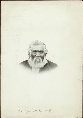
Photograph features a portrait of an elder taken from the neck up. Handwritten annotation on recto, along bottom of photo reads: “Chief Stlaituk”(?)
Photograph features an arranged collection of Chief’s ceremonial regalia: Chikat robe and Amalayt (headdress), two carved wooden rattles and two leggings.
Handwritten annotation in pen on recto reads: “Qush ahlied (?) or Chilcat [sic] Robe worn by Chiefs when entertaining. Also 'Ahm Ahlied'(?) or Head Ornament Indian Coronet and leggings." Verso also has additional handwritten annotations which have been crossed out.
Totem pole stands alone against a mountainous background.
Several unidentified individuals can be seen on front steps of church and a group of small children in white stand in line below steps. Other community buildings are visible in background, white fence crosses foreground. Photograph depicts the first church built in Metlakatla, which was burned in a fire in 1901, and replaced in 1903.
Handwritten annotation on verso reads: "Church (of England) at Metlakahtla - British Columbia. Built by the people of the village - largest church then on the pacific coast."
Group of five miners stand in mining area on left. Woman, man, and young girl sit and stand on far right in more formal attire. Mining tools and equipment throughout.
Printed annotation on recto of photograph: "Société Minière de B.C., Atlin B.C. July 28th, 1901, A.C. Hirschfeld, No. 707".
Several unidentified individuals can be seen on front steps of church and a group of small children in white stand in line below steps. Other community buildings are visible in background, white fence crosses foreground. Photograph depicts the first church built in Metlakatla, which was burned in a fire in 1901, and replaced in 1903.
Handwritten annotation on verso reads: "Old church at Metlakatla Before fire. Built by Fr. Duncan & the village people".
Large church stands behind white fence, unidentified man visible on front steps. Photograph depicts the first church built in Metlakatla, which was burned in a fire in 1901, and replaced in 1903.
Handwritten annotation on verso reads: "With love, from your two old friends JH [& AM Keen?]".
S. Barnabas’ Hove Parish Magazine. March 1902.
Subseries consists of correspondence between Grand Trunk Railway and other railway systems, particularly the Wabash Railroad Company.
Subseries contains ephemera related to the Grand Trunk Railway.
The Bishop sits at a table, drinking tea.
Handwritten annotation on verso reads: "[...?] taken at Eastbourne Missionary Exhibition March 1903 [...?]".
Three men stand in centre, each wearing a chief's dress and head-dress. Family members stand and sit on either side. Carved boxes and masks are positioned in foreground. The group poses in front of drapery hung against tall wooden wall.
Community members have stated that the people in this photo are from the Gitwilluyaxw clan from the wolf tribal house of Ksdiyaawak. The photo was taken at Gitlax̱t’aamiks along the Nass River.
Handwritten annotation on verso reads: "Tsimpshian Chiefs & family. Goods [for or fr.] Potlatch".
Photograph depicts fenced area in front of church building with turret. Other community buildings can be seen in background.
Handwritten annotation on verso reads: "Metlakatla Church. Replacement for larger church lost in village fire 1903?" See also item 2009.7.1.55 for similar image depicting new church building at Metlakatla, B.C.
Formal portrait of Rev. W.E. Collison, son of Archdeacon W.H. Collison. Handwritten note affixed to verso reads: "Rev. W.E. Collison Honorary Secretary Prince Rupert Branch".
Formal portrait of Archdeacon W. H. Collison seated with grandaughter Katherine (Katy) Collison on his lap and sons Rev. W.E. Collison standing on his right and Rev. H.A Collison standing on his left. Photographers printed signature on bottom right of matte board reads: "Savannah, Victoria, B.C."
File consists of the 1904 edition of a textbook by N. Hawkins entitled "New Catechism of the Steam Engine with Chapters on Gas, Oil and Hot Air Engines".
Photo of 2 men working with hand tools. Printed captions on verso read: "S.P.G. Missionary Post Card - No. 14.", "ERECTING A TENT CHURCH IN CALEDONIA.", "THE S.P.G. supports work in many of the dioceses of N.-W. Canada. The diocese of Caladonia was formed in 1879". Handwritten annotations in pencil on recto read: “PRINCE RUPERT AREA B.C.”, “The Rev S.B. Priston, Farm Cottage Farm lane, Fulham. Thankyou so very much for all you did last night. I am so sorry I did not see you after it was all over to thank you. R.A.[?] You never came to eat the [?] there are heaps.” Half pence postage stamp on recto is canceled with ink stamp reading "DE 7 04".
Photograph of a train traveling through Prince Rupert. Several people are gathered on the dock and around various buildings. Two small vessels are docked in the harbour. Annotation on recto reads: "Prince Rupert, Waterfront. Allen Photo May '4."
Close view of dock full of rows of nets and a few workers. Rows of bunkhouses on shore in background. Handwritten annotation in pencil on recto reads: “Port Essington B. C.”
Photograph depicts the sons and daughters of Marion and Archdeacon W.H. Collison posing in front of an archway covered in foliage, wood building in background. The Archdeacon stands behind his wife Marion who holds Katherine ('Katy') Collison, the oldest of their grandchildren. W.E. Collison stands on far left next to his wife Bertha nee Davis.
Handwritten annotation on verso reads: "Collison family / Kincolith BC".
The group poses in front of an archway covered in foliage, wood building in background. The Archdeacon sits in centre, in front of his wife Marion.
Handwritten annotation on verso reads: "Grand-dad + Grannie with family + friends at Kincolith / Mother + Dad lower left" (W.E. Collison sits on left in front of his wife Bertha).
Marion sits beside her husband, Archdeacon William Henry Collison, who wears clerical garb. Trees and foliage in background.
Handwritten annotation on verso reads: "Arch. Collison + Mrs. Collison."
View of building, dock, harbour and small islands with snow peaked mountains in background. Printed caption on verso reads: “Port Essington B.C. Photo by P. E. Fisher”. Handwritten annotation in ink on verso reads: “up the Skeena”, in pencil on verso: “Port Essington, North Coast Commercial Coy”.
Photo of church door with spire, front door and picket fence. Handwritten annotation in pencil on recto reads: “Port Essington B. C.”
Street scene depicting people, boardwalks, horse & wagons, and delivery truck. Printed annotation on recto reads: “3rd Ave. Prince Rupert. B.C.”
Typed annotation in red ink on recto reads: “3rd Ave. Prince Rupert. B.C.” People, boardwalks, horse & wagons and store signs are visible. Rubble and unknown material lies on ground between boardwalks. Typed annotation in red ink on recto reads: “3rd Ave. Prince Rupert. B.C.”
The New Era (2 editions) :
- The New Era: the official magazine of the Missionary Society of the Church of England in Canada. Vol. II, No. 4. Toronto: April 1904. (some annotations)
- The New Era: the official magazine of the Missionary Society of the Church of England in Canada. Vol. III, No. 4. Toronto: April 1905. (some annotations)
Photograph of a boardwalk street with buildings on either side, several people visible in image. Trees can be seen on street, and mountains stand in background. Handwritten annotation in pencil on verso reads: “Port Essington, North Coast Commercial Coy”.
View of dock full of rows of nets and a few workers. Sail boats are anchored near the dock and there are rows of bunkhouses in the mid ground, trees in the background. Handwritten annotation in pencil on recto reads: “Port Essington B. C.”
View of peninsula with houses and trees. Dock in mid ground, trees and grasses in foreground. Recto stamped “Port Simpson DE 17" and "Port Essington DE 18". Handwritten annotation on recto of photograph: "W. J. O'Neill Esq. Telegraph Point Via Pt. Essington B.C. Don't you think this pretty [Weggs & Mr. Byron?] was over last night - said he saw you and [Halie?]. Yours - BaBa".
Series 6 contains negatives and photographs illustrating the Taku River
Photograph depicts rocks among river rapids, opposite shore in background. Handwritten annotation on negative: "Rough water rap".
Image is one of 65 photos documenting a survey of the Canada-Alaska Boundary, Taku River area, May 23 to Oct. 15, 1906.
This particular photo is one of 13 found in original enclosure with the following handwritten annotation: "Kopoka River - river scenes Aug 29 to Oct. 9 [19]06". See also items 2006.20.3.2 - 2006.20.3.13.
Photograph depicts valley; rocky area in foreground, mountains in background. Handwritten annotation on negative: "[M?] Glacier main camp".
Image is one of 65 photos documenting a survey of the Canada-Alaska Boundary, Taku River area, May 23 to Oct. 15, 1906.
This particular photo is one of 13 found in original enclosure with the following handwritten annotation: "Kopoka River - river scenes Aug 29 to Oct. 9 [19]06". See also items 2006.20.3.1 - 2006.20.3.13.
Mountains stand behind water in background. Handwritten annotation on negative: "looking [over?] Kopoka".
Image is one of 65 photos documenting a survey of the Canada-Alaska Boundary, Taku River area, May 23 to Oct. 15, 1906.
This particular photo is one of 13 found in original enclosure with the following handwritten annotation: "Kopoka River - river scenes Aug 29 to Oct. 9 [19]06". See also items 2006.20.3.1 - 2006.20.3.13.
Photograph depicts two unidentified men on small boat with sail, opposite shore in background. Handwritten annotation on negative: "Prospectors on Taku Sailing".
Image is one of 65 photos documenting a survey of the Canada-Alaska Boundary, Taku River area, May 23 to Oct. 15, 1906.
This particular photo is one of 13 found in original enclosure with the following handwritten annotation: "Kopoka River - river scenes Aug 29 to Oct. 9 [19]06". See also items 2006.20.3.1 - 2006.20.3.13.
Photograph depicts river water in foreground, mountains in background. Handwritten annotation on negative: "Rough Water, Kopoka".
Image is one of 65 photos documenting a survey of the Canada-Alaska Boundary, Taku River area, May 23 to Oct. 15, 1906.
This particular photo is one of 13 found in original enclosure with the following handwritten annotation: "Kopoka River - river scenes Aug 29 to Oct. 9 [19]06". See also items 2006.20.3.1 - 2006.20.3.12.
Photograph depicts three unidentified men loading canoe on river shore.
Image is one of 65 photos documenting a survey of the Canada-Alaska Boundary, Taku River area, May 23 to Oct. 15, 1906.
This particular photo is one of 8 found in original enclosure with the following handwritten annotation: "From main camp up Kopoka River. Scenes with persons in." See also items 2006.20.3.14 - 2006.20.3.21.
Photograph depicts silhouette of unknown man standing in front of tent, trees in background. Poor image quality.
Image is one of 65 photos documenting a survey of the Canada-Alaska Boundary, Taku River area, May 23 to Oct. 15, 1906.
This particular photo is one of 13 found in original enclosure with the following handwritten annotation: "SOME OTHERS." See also items 2006.20.3.22 - 2006.20.3.34.
Unclear image of furry animal (wolverine?) moving among rocks.
Image is one of 65 photos documenting a survey of the Canada-Alaska Boundary, Taku River area, May 23 to Oct. 15, 1906.
This particular photo is one of 13 found in original enclosure with the following handwritten annotation: "SOME OTHERS." See also items 2006.20.3.22 - 2006.20.3.34.
Handwritten annotation visible on negative reads: "Valley of R. [Hills?] across Taku in distance."
Image is one of 65 photos documenting a survey of the Canada-Alaska Boundary, Taku River area, May 23 to Oct. 15, 1906.
This particular photo is one of 13 found in original enclosure with the following handwritten annotation: "SOME OTHERS." See also items 2006.20.3.22 - 2006.20.3.34.
Photograph depicts white water rapids between rocks of river. Forest on opposite shore in background, tree branches in foreground.
Image is one of 65 photos documenting a survey of the Canada-Alaska Boundary, Taku River area, May 23 to Oct. 15, 1906.
This particular photo is one of 13 found in original enclosure with the following handwritten annotation: "SOME OTHERS." See also items 2006.20.3.22 - 2006.20.3.34.
Image is one of 65 photos documenting a survey of the Canada-Alaska Boundary, Taku River area, May 23 to Oct. 15, 1906.
This particular photo is one of 13 found in original enclosure with the following handwritten annotation: "SOME OTHERS." See also items 2006.20.3.22 - 2006.20.3.34.
Photograph depicts narrow waterfall in steep cliff, trees and bushes visible above. Handwritten annotation visible on negative: "Waterfall on way up Taku River."
Image is one of 65 photos documenting a survey of the Canada-Alaska Boundary, Taku River area, May 23 to Oct. 15, 1906. This particular photo is one of 7 found in original enclosure with the following handwritten annotation: "Around River Taku and main camp on same." See also items 2006.20.3.35 - 2006.20.3.41.
Photograph features iceberg floating in water, mountains on shore in background.
Image is one of 65 photos documenting a survey of the Canada-Alaska Boundary, Taku River area, May 23 to Oct. 15, 1906. This particular photo is one of 7 found in original enclosure with the following handwritten annotation: "Around River Taku and main camp on same." See also items 2006.20.3.35 - 2006.20.3.41.
Water spans foreground, wind-blown trees stand on shore in background. Mountains visible in distance.
Image is one of 65 photos documenting a survey of the Canada-Alaska Boundary, Taku River area, May 23 to Oct. 15, 1906. This particular photo is one of 5 found in original enclosure with the following handwritten annotation: "Boundary No.2 camera Sta. Twin Lake & Glacier.” See also items 2006.20.3.42 - 2006.20.3.46.
Photograph depicts valley in snowy mountain range. Handwritten annotation visible on negative: "Pan. From Camera Sta no w. looking at [?] Glacier."
Image is one of 65 photos documenting a survey of the Canada-Alaska Boundary, Taku River area, May 23 to Oct. 15, 1906. This particular photo is one of 5 found in original enclosure with the following handwritten annotation: "Boundary No.2 camera Sta. Twin Lake & Glacier.” See also items 2006.20.3.42 - 2006.20.3.46.
Water spans foreground, trees can be seen in water, trunks submerged. Opposite shore and mountains in background.
Image is one of 65 photos documenting a survey of the Canada-Alaska Boundary, Taku River area, May 23 to Oct. 15, 1906. This particular photo is one of 5 found in original enclosure with the following handwritten annotation: "Boundary No.2 camera Sta. Twin Lake & Glacier.” See also items 2006.20.3.42 - 2006.20.3.45.
Water spans foreground, mountains of opposite shore stand in background.
Image is one of 65 photos documenting a survey of the Canada-Alaska Boundary, Taku River area, May 23 to Oct. 15, 1906. This particular photo is one of 10 found in original enclosure with the following handwritten annotation: "From [Wahut?]-Azmuth and Koshu.” See also items 2006.20.3.47 - 2006.20.3.56.
River flows through rocky area, mountains visible in background.
Image is one of 65 photos documenting a survey of the Canada-Alaska Boundary, Taku River area, May 23 to Oct. 15, 1906. This particular photo is one of 9 found in original enclosure with the following handwritten annotation: "Pictures of different members of ‘our’ party.” See also items 2006.20.3.58 - 2006.20.3.65.
Photograph depicts miscellaneous items and supplies in front of white tent. Unknown man stands in foreground and a second man can be seen sitting in tent. Stand of trees in background. Handwritten annotation visible on negative: "[?] Oct 13".
Image is one of 65 photos documenting a survey of the Canada-Alaska Boundary, Taku River area, May 23 to Oct. 15, 1906. This particular photo is one of 9 found in original enclosure with the following handwritten annotation: "Pictures of different members of ‘our’ party.” See also items 2006.20.3.57 - 2006.20.3.65.