Aperçu avant impression Fermer

Affichage de 91 résultats

Archival description
91 résultats avec objets numériques Afficher les résultats avec des objets numériques
2008.3.1.194 · Dossier · 1990-1995
Fait partie de Bridget Moran fonds

File consists of recorded DVD, containing the following video recordings:

  • Harkins! - Nov. 23, 1990
  • CKPG-TV excerpt- Oct. 3, 1992
  • CKPG-TV: Bob Harkins Comments- Dec. 18, 1992
  • CKPG-TV: Bob Harkins Comments- April 5, 1993
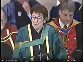
  • UNBC Convocation Address by Bridget Moran – May 26, 1995

DVD Summary

Context: DVD contains recordings originally broadcast on CKPG-TV News, the Prince George CBC affiliate station. It contains multiple recordings of either interviews with Bridget Moran or TV broadcast announcements and news stories relating to Moran’s publications and awards; as well as an excerpt from the May 1995 UNBC Convocation Ceremony featuring Moran’s Convocation Address.

Individual video segments as follows:

(1) Harkins!
Date: 23 November 1990
Length: 30’ minutes
Scope and Content: Contains a recording of a Bob Harkins of Harkins! interviewing Bridget Moran on her books Stoney Creek Woman, Judgement at Stoney Creek and her upcoming publication A Little Rebellion.

(2) CKPG-TV News excerpt Date: 3 October 1992 Length: 2’46” minutes
Scope and Content: Recording of CKPG-TV News excerpt featuring Bridget Moran speaking about her latest publication A Little Rebellion while at a Mosquito Books book signing event.

(3) CKPG –TV News: Bob Harkins Comments
Date: 18 December 1992
Length: 3’minutes
Scope and Content: November weather forecast for Prince George and region, followed by Bob Harkins Comments featuring Bridget Moran and her new book A Little Rebellion.

(4) CKPG –TV News: Bob Harkins Comments
Date: 5 April 1993
Length: 1’35”minutes
Scope and Content: Bob Harkins Comments featuring Bob Harkins speaking about Mary John and Bridget Moran receiving the Governor General’s Award for Outstanding Community Service from MP Brian Gardiner at a ceremony at Mosquito Books in Prince George.

(5) UNBC Convocation Address Date: May 26, 1995
Length: 11’53”minutes
Scope and Content: UNBC president Geoffrey R. Weller introduces Bridget Moran who then delivers her Convocation Address to the students of the May 1995 graduating class. Her speech focuses on change
– positive change - in the realm of education.

History of Prince George
2008.3.1.210.4 · Pièce · [between 1958 and 1960]
Fait partie de Bridget Moran fonds

Audio recording consists of individual taped interviews conducted by Bridget Moran with a number of early Fort George residents recalling the early years of white settlement in Prince George c.1910-c.1915. Interviews were conducted with the following individuals: Arnold Davis; J.A.F. Campbell; Alec Moffat; Claude Foot; George Henry; Nellie Law; John McInnis; Georgina [McInnis] Williams and Peter Wilson. These interviews were incorporated into the publication: Bridget Moran, Prince George Remembered…from Bridget Moran, Marsh Publishing, Prince George, 1996.

Audiocassette Summary
Scope and Content:Recording consists of individual taped interviews conducted by Bridget Moran in a number of locations with Arnold Davis; J.A.F. Campbell; Alec Moffat; Claude Foot; George Henry; Nellie Law; John McInnis; Georgina [McInnis] Williams; Peter Wilson

Subjects include:

  • Arnold Davis – former Sherriff in Prince George (born in 1882) arrived in Quesnel in 1909 and worked on the BX sternwheeler. Davis discusses his family roots from Ireland as a 6th generation Canadian. Recalls how his family arrived in South Fort George in 1917 and how his father worked on boats that went up and down Fraser River
  • Claude Foot recalls coming from New Zealand to Fort George [Prince George] in 1906 and how there were ‘very few white men’; his father was Irish, mother was English
  • Alex Moffat – describes how his parents provided a ‘stopping place’ for stage coaches in the Cariboo region
  • George Henry recalls working on the boats that plied the Fraser River between Prince George and Soda Creek, near Quesnel
  • Nellie Law – describes arriving from England in 1917 to Ashcroft and then Quesnel in 1917
  • Peter Wilson – Barrister and Solicitor; the prosecutor for Prince George since 1916 describes arriving by train from Edmonton and arriving on a scow in South Fort George
  • Mr. John McInnis – from Prince Edward Island, who sat twice in provincial legislature – in constituency of Grand Forks as socialist and later for constituency of Fort George recalls arriving in 1910 by rail to Kamloops and then by sleigh to South Fort George; describes the Indian Reserve at Fort George “[…don’t think there were a dozen white people…when I arrived […]”
  • J.A. ‘Doc’ Campbell recalls being part of a survey crew in Fort George in 1908
  • George Henry – also recalls cruising down the [Fraser] river by way of sternwheeler and losing men overboard
  • Peter Wilson recalls experiences as practicing lawyer; there was no assize court in the region until 1919; recalls some of his early cases [murder case]
  • Nellie Law describes working as a desk clerk at first The Alexandra Hotel and later The Prince George Hotel from 1918 to 1952
    Law describes the hotel patrons and how she met the Duke and Duchess of Devonshire in 1922. Recalls stoking furnace with logs in the hotel to keep it warm and working as a bouncer
  • Alex Moffat – recalls workers and hauling freight via the old Cariboo Road; existence of one policeman only (BC Provincial Police); and describes in detail a stopping place for horses / crew on the Cariboo Road and the pack trains.
  • Mr. Moffat – Describes the luxury experienced on the sternwheeler, The BX that “could carry seventy saloon passengers” and “staterooms were all equipped with push buttons, electric lights, hot and cold water, steam heat, and everything modern”
  • Claude Foot – Recounts a dance in Quesnel at the hotel barroom and describes ordering drinks at the Al Johnson Hotel that had a bar which boasted to be “ the biggest bar in Canada, if not the world” 100 ft + bar with “six or seven bartenders behind this long bar, and the customers would be lined up two or three deep […]”
  • J.A. [F.] [Campbell] – post-1910 changes with the use of scows on the Fraser River; describes the BC Provincial Police “in those days [they] just wore ordinary civilian clothes, but they were a tough bunch….[…]” and rowdiness in the bars in South Fort George
  • Campbell describes the first bank in Fort George was the Bank of British North America that was housed in a tent and he recalls needing money while playing poker - ‘about eleven o’clock that night, the vault was open, and the till was open, and if you wanted money you’d walk up to the bank till and put an IOU in and take money out and go on playing [poker]
  • Peter Wilson – comments about how lax the enforcement of law and order was in the early years including among the police themselves: “that the “Old Blind Nick [who] ran a bootlegging joint, went broke because he said he couldn’t afford to supply the police with any more liquor.”
  • Claude Foot – recalls a fire in Quesnel in 1916 that burned a large part of the business section and the firemen were as Nellie Law notes “ a bucket brigade of Chinamen, filling buckets from a water hole in the Fraser River that the horses drank in…”
  • John McInnis recalls political meetings and the election in 1916 when he was a candidate for the Fort George riding and being defeated by 7 votes; that the investigation of the election “was a whitewash”
  • Georgina McInnis, who was the first White Child born in the community – she tells of the meeting that decided her name – as Fort Georgina McInnis
  • Arnold Davis recalls his father working on boats that went up and down Fraser River and being on the boat with him and “watching the connecting rods go in and out and concentrate on pie…[served by the Chinese cook]” Davis also recalls The Yukoners who emigrated to PG after the Gold Rush
  • George Henry recalls with lament the coming of the railway as he lost his job plying the River - preferred voyages on the Fraser River – and refers to those who worked the River and himself as “river rats”
Pre-Emptor’s Map, Fort George Sheet
2008.2.1.02 · Pièce · 1916
Fait partie de Northern BC Cartographic Collection

Colour-coded map depicting lands open for pre-emption, lands in “University Reserve,” and lands reserved for public auction. Depicts land recording divisions, communities, bodies of water, transport routes, and game reserves.

Pre-Emptor’s Map, Fort George Sheet
2008.2.1.08 · Pièce · 15 February 1923
Fait partie de Northern BC Cartographic Collection

Colour-coded map depicting lands surveyed as alienated, reserved, Statutory Timber Lands, B.C. Land Settlement Board Area, or open for pre-emption. Depicts land districts, land recording divisions, communities, game reserves, bodies of water, transport routes, and communication lines.

Preliminary Map, Grenville Channel
2008.2.1.10 · Pièce · 1924
Fait partie de Northern BC Cartographic Collection

Colour-coded map depicting lands surveyed as alienated, reserved, and having a timber license, lease, or sale. Depicts land recording divisions, land district boundaries, communities, bodies of water, and transport routes. Includes insets of Stephens Island and Egeria Reach.

Pre-Emptor’s Map, Tête Jaune Sheet
2008.2.1.17 · Pièce · 1931
Fait partie de Northern BC Cartographic Collection

Colour-coded map depicting surveyed lands respectively open and closed to preemption. Depicts land recording divisions, game reserves, communities, bodies of water, and transport routes. Includes inset of McBride townsite.

Bulkley Sheet
2008.2.1.20 · Pièce · 1937
Fait partie de Northern BC Cartographic Collection

Colour-coded map depicts lands surveyed as alienated, available for purchase or lease under Taxation Act, or reserved. Depicts land district boundaries, land recording divisions, triangulation stations, telegraph/telephone lines, communities, bodies of water, and transport routes.

Stuart Lake Sheet
2008.2.1.22 · Pièce · 1 August 1940
Fait partie de Northern BC Cartographic Collection

Colour-coded topographic map depicting lands surveyed as alienated, available for purchase or lease under Land Act, or reserved. Depicts land district boundaries, land recording divisions, provincial forest boundaries, HBC posts, triangulation stations, telephone lines, communities, bodies of water, and transport routes.

Nechako Sheet
2008.2.1.23 · Pièce · 1 December 1942
Fait partie de Northern BC Cartographic Collection

Colour-coded topographic map depicts surveyed lands alienated, available for purchase or lease under Land Act, and available for pre-emption. Depicts land districts, land recording districts, provincial forests, parks, triangulation stations, communities, bodies of water, transport routes, and communication lines.

Peace River
2008.2.1.25 · Pièce · 2 January 1945
Fait partie de Northern BC Cartographic Collection

Colour-coded topographic map depicting surveyed lands alienated, available for purchase or lease, or available for pre-emption. Depicts land districts, land recording districts, parks, communities, bodies of water, transport routes, communication lines, and triangulation stations.

2020.4.4.37 · Dossier · 1974
Fait partie de G. Gary Runka fonds

File consists of a 1973 BC Land Commission photographic slide and audio tape set entitled "Land Commission Act and the Agricultural Reserve Plan" that was used in original public hearings throughout the province. The 80 slides included with the presentation materials were created mostly by Gary Runka. The audio cassette is a recording of the presentation with speakers Bill Lane, BC Land Commission Chair, and Gary Runka, BC Land Commission General Manager.

"The Land is Yours"
2020.4.4.38 · Pièce · [1968 or 1969]
Fait partie de G. Gary Runka fonds

This "The Land is Yours" film is a promotional film produced by the British Columbia Department of Agriculture in Kelowna, ca. 1968 or 1969. The film was produced by Gary Runka and hosted by Russ Richardson. Runka and Richardson provide commentary throughout the film. The film was directed by Nobert Hartig.

2016.5.5.08 · Pièce · 1964
Fait partie de Harry Coates fonds

Item is a map compiled and produced by Geographic Division, Surveys and Mapping Branch, Department of Lands, Forests, and Water Resources ; geological and physiographical data supplied by Dept. of Mines and Petroleum Resources, Victoria, B.C. (1964).

2017.5.1.4 · Part · [between 1951 and 1954]
Fait partie de Pacific Great Eastern Railway Film Collection

This clip of original film footage depicts Pacific Great Eastern Railway (PGE) track inspection with a V-8 vehicle.

Clip description with timing reference to scenes:

  • 0.01 The Fraser River above Marble Canyon near Moran
  • 0.22 At the Tunnel at mile 168.9 between Fountain and Glenfraser
  • 0.25 Scenes at Moran mile 181
  • 0.37 Inspecting the 2 tunnels at mile 186.5
  • 0.44 Water tank just north of Kelly Lake and south of the wye at Kelly Lake Mile Mile 191.5
  • 1.04 Wood Trestle at 51 mile creek Mile 206
  • 1.15 Lac La Hache station and section house in the background
  • 1.30 Williams Lake station
  • 1.43 Lone Butte Water tower
  • 1.46 The Lone Butte rock formation
  • 2.01 Alta Lake station right and Water tower in distance
  • 2.06 Outside the east side of the Squamish roundhouse. Track ahead of car leads to yard. Water tower to right
  • 2.15 A shot of the back side of the Squamish roundhouse looking south. 563 has had its trucks converted from 6 wheel to 4 wheel and is looking real clean. This must be late 1954. Steam locomotive 163 in final months of service and was cut up for scrap in July 1956
  • 2.20 Cheakamus
  • 2.24 Garibaldi Mile 59.5. Line to the left goes to the sawmill there
  • 2.27 Inspecting the bridge at mile 55.6 in the Cheakamus canyon. Looking south from the south end of the bridge. Telegraph wires in the right of clip
  • 2.31 Same bridge looking north
  • 2.37 Bridge at mile 56.5 in the Cheakamus Canyon
  • 2.42 Stopped at the water tank at the place called Watertank mile 62.5. Section house to the right of tracks.
  • 2.58 Heading north around Pinecrest Mile 64 or 65
  • 3.07 Stopped at the mill at Parkhurst around mile 80 on the east side of Green lake
  • 3.23 Watching a south bound train pass at Tisdall
  • 3.32 Diesel hauled train coming to Tisdall at the old location of the north switch. Locomotives still with their 6 wheel trucks so before 1954. Note locomotives spread out in the train so all the weight was not on small bridges at one time
  • 3.50 In the canyon north of Lillooet; man in brown suit and fedora is W.H. (Harry) Nichols
  • 3.58 Along Alta Lake
  • 4.12 Scenes along Anderson Lake north of Darcy
  • 4.35 Royal Engineers bridge at Lillooet
  • 4.42 GE diesel with either steam ditcher or steam crane just north of Lillooet
  • 4.47 General Store at Pavillion Mile 178.2
  • 4.52 Quesnel Station
  • 5.04 Unknown Location
  • 5.20 Gang working with tamping machine?
  • 5.31 Cottonwood River Bridge. New just before the line to Prince George opened in 1952. Also scenes around the Cottonwood River
  • 5.57 Ahbau Creek Bridge Mile 406.1 Prince George Subdivision. The last spike to complete the line to Prince George was driven at the north end of this bridge. Ahbau Creek was named after a local Chinese prospector and trapper
  • 6.16 At the CN Prince George shops near to where the Correctional Facility is today. CN Bridge across the Fraser River in distance
  • 6.37 Construction of the PGE crossing of the Fraser River at Prince George
  • 6.59 PGE middle yard at Prince George
  • 7.10 Heading back south to the main yard. CN Fraser River bridge in shot
  • 7.22 Marguerite station
  • 7.35 Hawks Creek or Deep Creek Bridge mile 329.9. One of the worlds highest railroad bridges at 312 feet high

Note: The miles in the notes are the current mileages. At the time of the filming the line to North Vancouver had not been completed. The mileages at that time would have read 40 miles less in the mile boards.

2023.2.2.12.5 · Dossier · 2007-2009
Fait partie de Dr. Paul Sanborn fonds

File contains the following data sets:

  • BC & Yukon 2008 soils data – compiled.xls [combined chemical & physical data for BC08-06, Y08-39, Y08-41, Y08-43]
  • S925finl.xls [chemical analysis data, Ministry of Forests & Range, Analytical Chemistry Laboratory for pedons BC07-03 & BC07-04; also includes data for Y07-06 & Y07-07 (Klutlan Glacier – see associated file note)]
  • S979finl(revised) – PS edits.xls [chemical analysis data, Ministry of Forests & Range, Analytical Chemistry Laboratory for BC08-06, Y08-39, Y08-41, Y08-43]
  • S994finl_revised.xls [chemical analysis data, Ministry of Forests & Range, Analytical Chemistry Laboratory for BC07-04 (CaCO3-equiv, total & inorganic C, pyrophosphate, oxalate & dithionite extractions) & selected horizons from BC07-07 & BC07-09 (Nazko basaltic soils))
  • CANTEST lab report 91010076.pdf [particle size analyses for BC08-06, Y08-39, Y08-41, Y08-43]
  • CANTEST lab report 90206003.pdf [particle size analyses for Tuya pedons BC07-03 & BC07-04 & Klutan Glacier pedons Y07-06 & Y07-07]
Klutlan Glacier soils study data
2023.2.2.13.1 · Dossier · 2007-2008
Fait partie de Dr. Paul Sanborn fonds

File contains the following data sets:

  • S925finl.xls [chemical analysis data, Ministry of Forests & Range, Analytical Chemistry Laboratory for pedons Y07-06 & Y07-07; also includes data for BC07-03 & BC07-04 (Boreal Cordillera grassland soils – see associated file note)]
  • S1007finl_revised2.xls [chemical analysis data, Ministry of Forests & Range, Analytical Chemistry Laboratory for pedons Y07-06 & Y07-07: oxalate & dithionite extractions, P retention; also includes P retention data for Nazko pedons BC07-07 & BC07-09]
  • CANTEST lab report 90206003.pdf [particle size analyses for Klutan Glacier pedons Y07-06 & Y07-07; also Tuya pedons BC07-03 & BC07-04 &]
2023.2.2.1.1.2 · Dossier · 1988-1990
Fait partie de Dr. Paul Sanborn fonds

During a year away from studies in 1987-88, Dr. Paul Sanborn developed a successful grant proposal to the Science Council of BC (SCBC) to pursue a postdoctoral project with Dr. Tim Ballard in relation to sulphur-deficient soils in BC and prescribed fire. This project built on an existing broadcast burning study conducted by Macmillan Bloedel Ltd. near Port Alberni on Vancouver Island, led by Bill Beese (later at Vancouver Island University). Dr. Sanborn's work addressed sulphur forms and amounts in the soils at these sites, and the chemical processes influencing sulphur availability in relation to prescribed fire.

Only one part of this work was eventually published:
Sanborn, P.T. and T.M. Ballard. 1991. Combustion losses of sulphur from conifer foliage: Implications of chemical form and soil nitrogen status. Biogeochemistry 12: 129–134. https://doi.org/10.1007/BF00001810

The remainder of the work was documented in this Project Completion Report to SCBC, dated February 28, 1990, and entitled "Effects of Prescribed Fire on Sulphur in Forest Soils".

Thirty-four data files were selected for archival retention. There is some redundancy of content among these, with some formatted for incorporation as tables in the report appendices, and others containing some of the same data, but set up as input files for a statistics program. These account for almost all of the data listed in the Project Completion Report appendices. No glossary of variable names is provided, but these should be identifiable by referring to the Report.

Gold Bottom soils data and descriptions
2023.2.2.3.2 · Pièce · 2004, 2023
Fait partie de Dr. Paul Sanborn fonds

Data set consists of lab data for sites Y04-01 to Y04-04. Original data set created in 2004; an update was provided in March 2023 but horizon designations were not updated to be consistent with the paper.

2023.2.2.7.3 · Dossier · 2009-2023, predominant 2009-2010
Fait partie de Dr. Paul Sanborn fonds

In July 2009, Dr. Paul Sanborn undertook the first soils field research at the Fort Selkirk volcanic field in central Yukon, with helicopter support and funding from the Yukon Geological Survey. This file includes the following data sets gathered from the research:

  • Ft Selkirk 110114069.xls [particle size analysis data, CANTEST]
  • S1090final.xlsx [chemical analysis data, Ministry of Forests & Range, Analytical Chemistry Laboratory]
  • S1112final.xlsx [chemical analysis data, Ministry of Forests & Range, Analytical Chemistry Laboratory]
  • Ft Selkirk 2009 soils data (updated Sept 15, 2010 and April 10, 2023).xls [consolidated lab data for all 2009 samples]
Ken Rutherford (Tape 1)
2008.3.1.210.7 · Pièce · 1 Apr. 1993
Fait partie de Bridget Moran fonds

Audio recording is of an interview by Bridget Moran with Ken Rutherford, educator and former municipal politician of Swift Current Saskatchewan. Rutherford was an Alderman prior to becoming Mayor of Swift Current from 1944-1952, he ran unsuccessful for the CCF in 1960 and later for the NDP. Rutherford ran for political office in BC in the electoral district of Fort George in 1963 unsuccessfully against Liberal MLA Ray Williston. The interview includes biographical information as well as memories of his career as a school teacher, his political aspirations and involvement with the CCF and later the NDP and the history of medicare in Canada.

Audiocassette Summary

  • Rutherford provides genealogical information on grandfather and his mother (her family was from Moose Jaw, Saskatchewan)
  • Discusses his parent’s marriage
  • Recalls schooling in Swift Current, Saskatchewan where he eventually becomes principal
  • Rutherford notes he never went to university, but went to Normal School
  • Talks about his wife and children
  • Donley Hill
  • Recalls joining the CCF and distributing pamphlets; recalls 1935 election and CCF getting few votes
  • Recalls salary troubles at the school in Swift Current in the 1930s and being both the teacher and janitor
  • He was Mayor of Swift Current from 1944-1952; and previously as Alderman and ran for the CCF in the federal election in 1953;
  • Recalls spoiled ballots in the election
  • Recalls getting involved with the issue of health premium payments in Swift Current c.1940s.
  • Recalls the history of the fight for health care in Canada; and strike in Saskatchewan by doctors
  • Recalls the national fight for Medicare – 1961
  • Discusses Tommy Douglas; Mackenzie King
  • Health care issues
Northern British Columbia
2008.2.1.18 · Pièce · 1 May 1933
Fait partie de Northern BC Cartographic Collection

Regional map depicting communities, parks, customs posts, airports, radio stations, hatcheries, bodies of water, transport routes, communication lines, elevation points, and lines of batholith contacts. Includes an inset of St. Elias Mountains. Includes “Special Note on the Mineralization of this Map Area” from Bureau of Mines, Victoria, B.C.

2023.2.2.1.3.8 · Dossier · 2003-2010
Fait partie de Dr. Paul Sanborn fonds

Data sets for the Sulphur stable isotope tracer study (E.P. 886.15) include:

  • 03-095 UNBC PS-For.xls Particle size analyses (Kenneth Creek 0-20 & 20-40 cm)
  • 03-096 UNBC PS-For.xls Particle size analyses (Holy Cross 0-20 & 20-40 cm)
  • 082037.xls XRF elemental analysis (Holy Cross pedon)
  • 082038.xls XRF elemental analysis (Kenneth Creek pedon)
  • 084996.xlsx XRF elemental analysis (HC & KC parent materials)
  • EP 886 15 S isotope data (2001-2005) - foliage_completed (Feb 18).xls Pine foliage d34S (total S & total SO4-S)
  • EP 886.15 2003 Foliage & Soil Chemistry Summary.xls
  • EP 886.15 Foliar Analyses (selected) 2001-2006.xls Total N & S, SO4-S
  • EP 886.15 Holy Cross & Kenneth Creek 2005 foliage.xls
  • EP 886.15 Holy Cross & Kenneth Creek 2006 foliage.xls
  • EP 886.15 Holy Cross 2001 FH (S516FINL).xls
  • EP 886.15 Holy Cross 2001 Foliage (T727FINL).xls
  • EP 886.15 Holy Cross 2001 Litter (S515FINL).xls
  • EP 886.15 Holy Cross 2001 Mineral Soil (0-20 cm) (S507FINL).xls
  • EP 886.15 Holy Cross 2002 Foliage (T785FINL).xls
  • EP 886.15 Holy Cross 2003 FH (S642FINL).xls
  • EP 886.15 Holy Cross 2003 Foliage (T836FINL).xls
  • EP 886.15 Holy Cross 2003 Litter (S641FINL).xls
  • EP 886.15 Holy Cross 2003 Mineral Soil (0-20 cm) (S643FINL).xls
  • EP 886.15 Holy Cross 2004 FH (S702FINL).xls
  • EP 886.15 Holy Cross 2004 Foliage (T904FINL).xls
  • EP 886.15 Holy Cross 2004 Litter (S701FINL).xls
  • EP 886.15 Holy Cross 2004 Mineral Soil (0-20 cm) (S703FINL).xls
  • EP 886.15 Kenneth Creek 2001 FH (S521FINL).xls
  • EP 886.15 Kenneth Creek 2001 Foliage (T727FINL).xls
  • EP 886.15 Kenneth Creek 2001 Litter (S520FINL).xls
  • EP 886.15 Kenneth Creek 2001 Mineral Soil (0-20 cm) (S508FINL).xls
  • EP 886.15 Kenneth Creek 2001 Mineral Soil (20-40 cm) (S509FINL).xls
  • EP 886.15 Kenneth Creek 2002 Foliage (T785FINL).xls
  • EP 886.15 Kenneth Creek 2003 FH (S645FINL).xls
  • EP 886.15 Kenneth Creek 2003 Foliage (T837FINL).xls
  • EP 886.15 Kenneth Creek 2003 Litter (S644FINL).xls
  • EP 886.15 Kenneth Creek 2003 Mineral Soil (0-20 cm) (S646FINL).xls
  • EP 886.15 Kenneth Creek 2003 Mineral Soil (20-40 cm) (S647FINL).xls
  • EP 886.15 Kenneth Creek 2004 FH (S705FINL).xls
  • EP 886.15 Kenneth Creek 2004 Foliage (T905FINL).xls
  • EP 886.15 Kenneth Creek 2004 Litter (S704FINL).xls
  • EP 886.15 Kenneth Creek 2004 Mineral Soil (0-20 cm) (S706FINL).xls
  • EP 886.15 Kenneth Creek 2004 Mineral Soil (20-40 cm) (S707FINL).xls
  • EP 886.15 Sample Inventory.xls Listing of MoF Lab Job No.'s
  • Fertilizer March 2003.xls d34S data for commercial fertilizer S sources
  • hc_2002.xls Initial (2002) pine tree measurement data - Holy Cross
  • kc_2002.xls Initial (2002) pine tree measurement data - Kenneth Creek
2023.2.2.2.7 · Dossier · 1996-2005
Fait partie de Dr. Paul Sanborn fonds

Data sets associated with the Arocena & Sanborn 1999 regional soil mineralogy study:

  • S234FINL.XLS [data report for mineral horizons from MoF Analytical Chemistry Laboratory, June 20 1996]
  • S235FINL.XLS [data report for organic horizons from MoF Analytical Chemistry Laboratory, June 20 1996]
  • SAMPLIST.XLS [conversion table for sample numbers used in MoF lab data reports]
  • Fe Al extractions.xlsx [assembled from lab data report by L. Arocena for oxalate & dithionite extractions; pyrophosphate extraction data from MoF lab]
  • MINSTUDY.XLS [consolidated lab data for organic & mineral horizons, except for BaCl2 exchangeable cations]
  • MINCEC.XLS [BaCl2 exchangeable cations & Morgan’s extraction for organic & mineral horizons]
2023.2.2.6.3 · Dossier · 1983-2009
Fait partie de Dr. Paul Sanborn fonds

During the 1980s, Agriculture Canada pedologists Scott Smith (retired from Summerland Research Station, formerly based in Whitehorse) and Charles Tarnocai (retired from Central Experimental Farm, Ottawa) had a large field program which addressed the trends in soil development in the central Yukon. Across this region, particularly between Whitehorse and Dawson City, the land surfaces and surficial deposits vary greatly in age due to the differing extents of glaciations over the past ~2 million years.

Tarnocai and Smith shared the unpublished data and soil samples from this work with Dr. Paul Sanborn, and this resulted in a student project published as:
Daviel, E., P. Sanborn, C. Tarnocai, and C.A.A. Smith. 2011. Clay mineralogy and chemical properties of argillic horizons in central Yukon paleosols. Canadian Journal of Soil Science 91: 83-93. https://doi.org/10.4141/cjss10067

This data set consists of transcribed data from lab data sheets, showing McQuesten-Dawson City paleosol data from the Tarnocai and Smith 1983 AAFC Yukon Paleosol Study. The data set includes chemical and particle size data for Tarnocai & Smith samples, as determined by the Ag Canada lab. Note that the “Site” column indicates the NTS topographic map sheet (e.g. 115P/13) for the sampling locations.

Kluane Lake soils research data
2023.2.2.8.06 · Dossier · 2003-2014
Fait partie de Dr. Paul Sanborn fonds

File consists of the following data sets:

  • Kluane crust Min N (2003) S671FINL.xls [mineralizable nitrogen for biological soil crusts & upper mineral soil, 2003 samples]
  • Kluane Crust samples (2004) moisture contents.xls [moisture content of air-dry 2004 crust samples from Peninsula & Silver City sites; sampling procedures & locations in Marsh et al. (20060]
  • Kluane Soil Crusts (2004) chemical analyses.xls [consolidated file of chemical data for 2004 crust samples from Peninsula & Silver City sites]
  • Kluane 2003 soil & crust 15N data.xls [15N natural abundance, total N, organic & inorganic C for 2003 crust & upper mineral soil samples]
  • Kluane 2003 soil data.xlsx [consolidated file of chemical data for 2003 crust and mineral horizon soil samples]
  • Kluane Crust 2004 total C & N data.xls
  • Kluane AMS dates (2003-2008 charcoal samples).xls [radiocarbon dates from the University of Arizona Accelerator Mass Spectrometry Lab]
  • Kluane soil transect - texture data.xls [2009 soil particle size analysis data, with potential lithological breaks highlighted]
  • Kluane surveys 2009.xls [topographic surveys for 3 soil transects cutting across eskers along Cultus Bay Rd., SE shore of Kluane L.]
  • S1061_1069_Final_Rev1.xls [lab data report from Ministry of Forests Analytical Chemistry Laboratory for 2009 transect samples: total C, inorganic C, & total N]
  • 100812003 (annotated) -corrected.xls [2009 transect samples: particle size analysis data report from CANTEST]
  • Kluane soil transect - master data file.xls
The Mark of Progress
2016.5.3.16.1 · Pièce · 1959
Fait partie de Harry Coates fonds

A VHS tape containing "The Mark of Progress" film created by the British Columbia Forest Service and first played for a live audience in 1959 in Prince George, BC.

2008.3.1.210.1 · Pièce · [ca. 1960]
Fait partie de Bridget Moran fonds

Audio recording is of an interview by Bridget Moran with both Mr. George Henry and Mr. Arnold Davis to discuss their memories of the early town site development of South Fort George and Central Fort George c.1910-c.1917. Mr. Henry was born in 1882 and his family arrived in Quesnel in 1909. Mr. Henry’s interview is primarily about his work as a captain on the BX Sternwheeler up until the time of the railroad arriving in Prince George in 1914. Mr. Davis, who was a Sherriff in Prince George, recalls his childhood memories of Fort George and Central Fort George c.1917. Mr. Davis also discusses his family roots from Ireland, the family’s arrival in Fort George from Ashcroft in 1917 and memories of his father who worked on the sternwheelers on the Fraser River.

Audiocassette Summary

Scope and Content:
Interview with Mr. George Henry

Mr. Henry was born in 1882 in Northern California and his family came to the Cariboo in 1909. He recalls riding his bicycle from Ashcroft to Quesnel in 3 days to find work with the BC Express Company.

Mr. Henry recalls working on the BX and describes the sternwheeler trip from Quesnel to South Fort George; it was a 3 hour trip from Quesnel and included two mail stops ;
Henry recalls an accident onboard the sternwheeler going through the Fraser Canyon (see p.p.11-12 of
Prince George Remembered)

Mr. Henry describes his homestead at South Fort George

Mr. Henry describes the BX sternwheeler being aground at South Fort George c.1920

Mr. Henry recalls spending winters in South Fort George in his log cabin; that work was “plentiful” in 1910 and the population at “about 700”
Mr. Henry notes that the “Indian reserve was at the Hudson’s Bay company” and that the native population was at “about 50”

Mr. Henry recalls the early commercial businesses in South Fort George c.1910 including the Northern Hotel; the candy store and ice cream store and theatre.

Mr. Henry describes the start of the town site of Central Fort George as a “viable little town” which started once the Grand Trunk Railway arrived and recalls the change in population between South Fort George & Central Fort George.

Henry recalls how all the workers came and lived in tents in Central Fort George.

Mr. Henry was not happy about the arrival of the railway as it meant he lost his job on the sternwheeler – he recalls that “us old river rats were just lost” (see p.p.34 of Prince George Remembered)

Bridget then asks Mr. Arnold Davis to recall his memories of early South Fort George
But first asks him to describe his family’s roots (See p.p. 1-2 of Prince George Remembered)

Scope and Content:
Interview with Mr. Arnold Davis

Davis notes he is 6th generation Canadian; family came from Ireland and his grandfather’s brother Jeff Davis became the President of the Confederate States of America.
Davis refers to his mother’s family being on the Prairies at time of the trial of Louis Riel

Davis explains that his grandfather first homesteaded at Banff; then Kamloops; then Ashcroft and on to South Fort George in 1917.

Davis’ father worked for the BC Express Company and he recalls being on the sternwheeler as a child during same time that George Henry worked the boats. Recalls workers on the boat; eating pie on the boat baked by the Chinese cook; (See p. 33 of Prince George Remembered)

Davis recalls the town site of South Fort George. He notes it had a population by 1917 of only “about 300” and that the “boom was over”

Davis describes location of various businesses in South Fort George including the Rex Theatre, George St. Poole Room, McKay Bros. Grocery store, Drugstore, Bairds, Peters Butcher Shop.

Davis recalls that there were many “Yukoners” here at the time and recalls a tale about an old Yukoner

Mr. Davis recalls other people who worked on the BX with his father including Margaret “Granny” Seymour’s father;

Mr. Davis recalls riding up and down the river to Foley’s Cache on the sternwheeler as a child
Mr. Henry then speaks up and recalls trips on the sternwheeler with Arnold Davis on the boat as a child

Tape ends