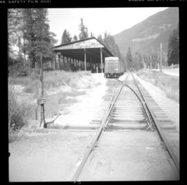
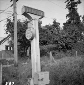
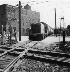
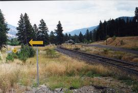
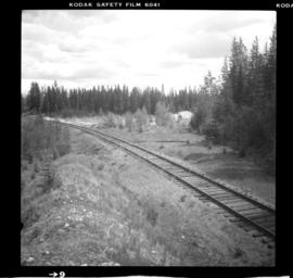
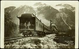
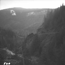
Photograph depicts the Great Northern Railway, now called the Burlington-Northern Railway which had a branch line from Kettle Falls to "Republic" that at one point crossed into Canada via Grand Forks. The view shows the exit (cattle guard) from Canada (B.C.) to Washington.
Photograph depicts the Great Northern Railway (now Burlington-Northern Railway) line between Spokane and Nelson. Visible is a shed for lumber. Image captured looking upgrade and northeast. It had a 27 car siding.
Photograph depicts the rear of the Great Northern depot on Main St. in Vancouver, that is now demolished.
Photograph depicts a Great Canadian Rail Tour Company train, the Rocky Mountaineer, on CN track, north of Walhachin.
Photograph depicts a gravel pit 1.5 miles north of the McCulloch depot or at approximately mile 78.0, on the Carmi Subdivision. It has not been in use since at least the late 1950s. The rails here are worn and dated 1910 and 1920s. The view is looking north.
Photograph depicts a gravel pit located 1.5 miles north of McCulloch CPR depot, which is at approximately mile 78, on the Carmi Subdivision. The gravel pit has not been used for at least 20 years. The picture also shows a disused spur line.
Photograph depicts a disused gravel pit near the McCulloch CPR depot, on the Carmi Subdivision. The pit had not been used for at least 20 years. The view is looking south.
Plan depicts Granville Island industrial sites in False Creek, Vancouver. Shows revised trackage from 1955 annotated in colour by Davies.
Photograph depicts a B.C. Hydro Railway locomotive switching a flat car filled with construction equipment.
Photograph depicts a B.C. Hydro locomotive switching a flat car carrying a cat crane. Looking west with Granville road bridge in the background.
Image depicts a large, electric shovel at a mine site somewhere in Granisle, B.C.
Image depicts a drill for blasting holes at a mine site somewhere in Granisle, B.C.
Image depicts numerous bags of blasting powder at a mine site somewhere in Granisle, B.C.
Image depicts an 80 tonne truck at a mine site somewhere in Granisle, B.C.
Photograph depicts group of buildings at Grande Prairie airstrip. The foremost building has the sign "YUKON SOUTHERN" on its roof, and the tower and admin building can be seen behind. Power poles, large trucks, and other large unidentified machinery are lined up in background on right.
Royal Canadian Air ForcePhotograph depicts building with small second story attached, and a tall red and white pole in front. Signal tower and power poles in background on right, semi-trailer in background on left. A man in uniform can be seen in the far right sitting on a small staircase on wheels. Small unidentified buildings and miscellaneous shop supplies in background. Handwritten photo album caption beside this photo reads: "Grand Prairie Tower and Adm. Bldg."
Royal Canadian Air ForceFront view of several men working on Grand Trunk Pacific train 218 in the winter. Handwritten annotation in pencil on verso of postcard reads: “Prince George, B.C., Dec. 1921 yard & main line.”
Photograph depicts construction of a Grand Trunk Pacific Railway trestle by Bostrom & Green Contractors near Fort Fraser, BC.
Handwritten annotation on verso of photograph: "G.T.P. 1st Passenger Train From Prince Rupert. Mile 45. June. 14th 1911. Copyright. F. Button. PHOTO. Pr. Rupert. No. 240." Photograph depicts three men (two sitting on chairs) on caboose of train. Power poles run parallel to tracks, which curve to the right of the image. Train tracks in foreground, forest and mountain in background.
Photograph depicts what appears to be two trains and a long building on high level of river bank. Fraser river in foreground, forest trees on shore in background.
Photograph depicts a train and long building on high level of river bank. Fraser river in foreground, forest trees on shore in background.
Photograph depicts Grand Trunk Pacific locomotive 624 and equipment at a railyard.
Photograph depicts a Grand Trunk Pacific flatbed train car carrying logs. One man is standing on top of the logs, while four more pose in front of the car on the tracks. Water tower visible in background.
Photograph depicts the Grand Forks CPR depot, located at mile 94.8 on the Boundary Subdivision, which runs from Nelson to Midway (127 miles). It was originally built by the Columbia & Western Railway in 1899. IT has not seen a passenger train in years but it is still in use for administrative purposes.
Photograph depicts the a grain elevator at Wynndel, located at mile 73.8 on the CPR line on the Nelson Subdivision. It is between Creston at mile 67.2 and Kootenay Landing at mile 83.1. Grain elevators are rare in BC and this one belongs to the United Grain Growers. The view is looking east.
Image depicts a large vessel docked at a grain elevator and two smaller boats at a dock in the foreground somewhere in Prince Rupert, B.C.
Typed caption glued to album page directly below photograph reads: "40. Grading at Fort Fraser." Photograph depicts a steam train engine pushing three cargo cars along a train track. Photographer: Dominion Stock & Bond Corporation
Typed caption glued to album page directly below photograph reads: "11. Grading at Fort Fraser." Photograph depicts railway construction workers loading dirt and rocks from the track being laid, into cargo cars attached to a steam train engine. Photographer: Dominion Stock & Bond Corporation
Photograph depicts a grader that was working on removing a sharp bend and widening Galena Bay Road.
Photograph depicts the grade of a former railway between Kaslo and New Denver, just on the east side of the summit at Retallack.
Photograph depicts a recently constructed grade that ran parallel to the BC Hydro Railway and led to a new super post. A CPR ballast train is visble on the track. Ownership of the line was vested in the BC government.
Photograph depicts a C.P.R. grade crossing warning device at Haney.
Photograph depicts a Goodyear Blimp cruising over the Centennial Museum near Sunest Beach, False Creek, Vancouver.
Photograph depicts a goodyear Blimp cruising over the Centennial Museum near Sunest Beach, False Creek, Vancouver. It came for the 1973 Abbotsford Air Show.
Photograph depicts a Goodyear airship travelling over Spanish Banks, Vancouver. It took part in the Abbotsford Air Show of 1971.
Image depicts the old Goat River Train Station in Goat River, B.C.
Image depicts the CN Railway and Station at Goat River, B.C.
Photograph taken at the Great Northern Railway connection from its terminal yards to its wharf on Vancouver Harbour or the connection with CPR. Image captured crossing Powell Street, looking southward, north of Glen Drive, Vancouver.
Photograph depicts a bridge over the Similkameen River. When track ran to Hedley, there were 3 of these bridges. All stood still at the time the photograph was captured. The other were on the lifted Keremeos to Hedley section.
Photograph depicts a rail bridge over the Similkameen River.
Photograph depicts a bridge over the Similkameen River. The branch was still in use with very little traffic. One padlocked door on each side of the bridge allows examination of trusses.
Photograph depicts the GNR (later became BN) branch from Kettle Falls to Grand Forks.
Image depicts a street in Giscome B.C. The Giscome Store is located on the left side of the image with the church in the background. Map coordinates 54°04'18.5"N 122°21'57.7"W
Image depicts the old Giscome Train Station in Giscome, B.C. It was demolished between 1976 and 1977.
Photograph depicts people on river shore, and boat and buildings in midground. River bank in foreground, forest in background. Handwritten annotation on verso of photograph: "Giscombe Portage Fraser River", on recto: "Huble & Seaback on Fraser River."
Photograph depicts people and tree stumps in grass areas. Buildings stand on higher level in midground, forest in background. Handwritten annotation on verso of photograph: "Giscombe Portage. B.C.", on recto: "Seaback & Huble"
Image depicts a parking lot full of vehicles with the Giscome store in the background. Map coordinates 54°04'18.5"N 122°21'57.7"W
Image depicts the Giscome railway station and buildings remaining in townsite in Giscome, B.C. Map coordinates 54°04'18.0"N 122°22'04.7"W
Image depicts what is possibly the CN Railway Station and tracks located in Giscome, B.C.