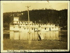
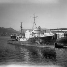
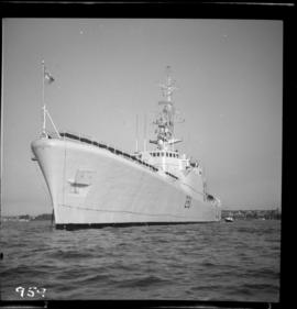
Photograph depicts the H.M.C.S. Beacon Hill at English Bay in Vancouver during the maritime festival.
Photograph depicts a hi-rail crane that was located in the Cn Junction yards, Kamloops.
Image depicts a van on a highway with mountains in the distance; the location is uncertain, though it is possibly along the Alaska Highway.
Image depicts an aerial view of the Williams Lake Airport along Highway 97, just north of Williams Lake, B.C.
Image depicts an aerial view of Highway 97 just north of Williams Lake, B.C.
Image depicts a view along Highway 97 in Prince George, B.C.
Image depicts a section of Highway 97 looking south. Map coordinates 53°55'10.3"N 122°46'54.9"W
Image depicts the Skeena River alongside Highway 16 en route to Prince Rupert, B.C.
Image depicts a highway, possibly Highway 97, in Prince George, B.C.
Photograph depicts Bert Glassey in winter gear standing with snowshoes and what appears to be a dogsled. Bushes and trees in background. Typed annotation on recto of photograph: "The Tribulations and privations of a Coroner in Northern British Columbia. April 18th, 1936. Taken in the Teslin Lake country of B.C."
Group of seven men and one woman stands under wing of plane. Glassey stands fourth from left, field and hills in background.
Glassey stands with a cigarette to right of large building, parking lot in background.
Photograph depicts H.F. Glassey sitting on bench on upper deck of unidentified watercraft, rope ladder in background. Handwritten annotation on recto of photograph: "To Sarah for old Times Sake. Yours Bert."
The pair walks on sidewalk, wearing hats and long coats, Glassey on right. Crowd of walking people and tall buildings in background. Photograph taken by street photographer. Stamped annotation on recto of photograph: "SOUVENIR SNAPS 401 W. HASTINGS ST. VANCOUVER, B.C. EXTRA COPIES BY NUMBER."
View of fish boat in water, with net spread and smaller boat on opposing side of net. Several gulls can be seen flying in the air. Rail cars town and treed hills in background. Printed annotation on recto reads: “Herring Fishing In Prince Rupert Harbour McRae Bros.” Handwritten message in ink on verso is addressed to “Mr. H. Smart 2550 Blackwood St. Victoria B.C.”
Hermina stands on shore close to water's edge at South Fort George. A power pole stands in water midground, in front of large white riverboat. Tree-covered hill on opposite shore in background. Handwritten annotation on verso of photograph: "Mother near the boats when the water was high."
Photograph depicts a Fairmont section gang "motor car." Property of Kamloops Heritage Railway. On display at the CNR station in downtown Kamloops.
Photograph depicts row of houses behind trees. Power line, road, and vehicles in foreground; mountain in background.
Photograph depicts row of houses behind trees. Road, front yards, and vehicle in foreground, mountains in background.
Photograph depicts two unidentified men in front of yellow and red helicopter at unknown location. Power lines and trees in background. It is possible that this photo may have been taken at Clinton Creek, Y.T. rather than Cassiar, B.C.
Photograph depicts plant buildings in front of tailings pile in midground. Forest, power line, and tramline in foreground; south mountains in background.
Image depicts a man standing in front of a helicopter; a waterfall is visible on the cliffs in the background. The slide itself is labelled "BC Parks Tour."
Image depicts a piece of heavy machinery lifting numerous logs. It is likely located in Prince George, B.C.
Image depicts a piece of heavy machinery lifting numerous logs off the back of a logging truck. It is likely located in Prince George, B.C.
Photograph depicts Hazelton Bridge that was believed to be built in 1930. Crossing the Skeena River.
Photograph depicts the Hazelton suspension bridge.
Photograph of a large wooden bridge across Hayes Creek, Prince Rupert, BC. Printed annotation on recto reads: "Hayes Creek Bridge Prince Rupert BC." Handwritten annotation on recto reads: "Dear Mary. Why don't you and my letter hyp[illegible] old [illegible] Louisa A./ P.O. Box 32./ P.R." Handwritten address on verso reads: "Miss Mary Wonoghue Prideaux St., Nanaimo. B.C." Postcard is affixed with a one cent Canadian stamp. Postmarks on verso read: "Prince Rupert B.C. PM Jun 18 11." and "Nanaimo B.C. 18 Jun 21 11."
Handwritten caption beside this photo reads: "Haulback Rig on a D8 Cat". Photograph depicts the rig in operation, two operators standing on the caterpillar (only one face visible). These men are believed to be Fred Youngstrom on left, and his foreman on right [see 2005.3.31]. Dirt and debris in foreground, forest in background. It is believed this rig is operating in a long-line skidding system.
Image depicts the road leading to the historic Hat Creek Ranch site north of Ashcroft, B.C. Several individuals are sitting on the front porch of the Ranch house.
Handwritten annotation on recto of photo reads: "Harry Monson Edmonton Prince George." Harry reclines on bed under window, surrounded by personal effects. Photograph was taken after nightfall. Handwritten caption beside this photo reads: "Harry talked my dad into selling him my boat".
Image depicts a road leading into a First Nations' Reserve at the head of Harrison Lake.
Photograph depicts Coal Harbour in Vancouver. The photo is facing land fill with stone on the tidal side. The site is for the first block of the Harbour Park Development Ltd. high rise apartments.
Photograph depicts the Harbour Park Development site in Coal Harbour, Vancouver. Taking rock from the scow to face fill with anti-erosion material. The site is for new high rise apartments at the edge of Stanley park between Georgia St. and the sea.
Elevated view of the buildings along the Prince Rupert shore, including the Prince Rupert Inn. The waterfront and some small islands can be seen in the background. Printed annotation on recto reads: "Harbour, Prince Rupert, B.C. 1658."
Boats, docks, ships and a large building in waterscape. Printed annotation on recto reads: “Prince Rupert B.C.” Handwritten annotation in pencil on verso reads: “McRae Bros”.
Image depicts the Hansard railroad bridge looking west. Map coordinates 54°04'37.9"N 121°50'46.3"W
Photograph depicts the hand truck and track material at Tilbury, Delta in the Fraser Valley. It belongs to the Canadian National Railway (CN)
Photograph depicts a hand car owned by the Kettle Valley Steam Railway. Behind it was a Woodings inspection car.
Photograph depicts a hand car at the Fort Steele Railway Museum. Built by Fairmont of Canada.
Photograph depicts the Hanceville Bridge that went over the Chilcotin River.
Photograph depicts Hamilton St. in Vancouver. The photo was taken at the back of 1250 Homer St, but is actually on Hamilton St., looking east. The left-hand line is in regular use, but the siding on the right hand side is not.
Photograph depicts the "Haida Chieftain" tug of the Kingcome Navagation Ltd. at their wharf in Vancouver.
Photograph depicts an unidentified individual leaning against a large overturned dugout canoe; barrel, bucket, and wood planks in foreground. Houses and other buildings can be seen on shore above beach, and two unidentified individuals stand in distance on far right.
Handwritten annotations on verso read: “Haida canoe on beach at Masset / ? 1898”; “No. 4 Page 5. Haida Canoe ready for steaming to [widen?] out and finish.”
An original negative of this photograph is held by the Canadian Museum of Civilization, no. 26664.
Close view of bridge built with wooden planks, poles, and wires, braced from below, with triangles built into its frame. The bridge crosses Hagwilget Canyon on the Bulkley River, five kilometres from its confluence with the Skeena River. This is one of the many bridge structures that have crossed this location since at least 1859. Photograph was taken from one side of canyon, near bridge. Opposite canyon wall in background. Typed annotation glued to verso of photograph: "HAGWILGET - 'the gentle or quiet people'."