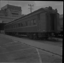
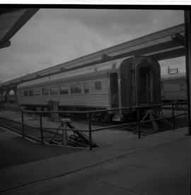
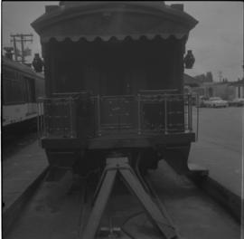
Photograph taken at the VIA Rail depot in Vancouver. Visible is a former Grand Trunk Pacific car, 'Nechako,' now CNR #15105. It was a fairly permanent fixture with steam, water, and waste lines fixed up to the depot's facilities.
Photograph taken at the VIA Rail depot in Vancouver. Visible is a VIA Rail car #117 that is clad in stainless steel.
Photograph taken at the VIA Rail depot in Vancouver. Image captures the view end of the Grand Trunk Pacific Railway car, now called the CNR 'Nechako' #15105. Davies notes that it was normally spotted at the location as a semi-fixed installation.
Image depicts a property given to the Veterans of the Second World War, located on the corner of 15th Avenue and Elm Street in Prince George, B.C.
Photograph depicts three flagbearers and other veterans in front of Prince Rupert courthouse at the Remembrance Day ceremony.
Photograph depicts three flagbearers holding the Canadian, British, and Prince Rupert legion flags with other veterans in front of Prince Rupert courthouse at the Remembrance Day ceremony.
Photograph depicts three flagbearers lowering the Canadian, British, and Prince Rupert legion flags with other veterans in front of Prince Rupert courthouse at the Remembrance Day ceremony.
Water level photograph of several vessels docking in Prince Rupert. The "Co Op Fish Liver Oil" building is visible in the background. Printed annotation on recto reads: "Docks Prince Rupert."
Photograph depicts two velocipedes on the CPR Kettle Valley Railway in Myra Canyon. They were privately owned and located at the southern entrance of the tunnel at mile 86.3.
Photograph depicts a velocipede at about mile 86.4 on the Kettle Valley Railway in Myra Canyon. The view is looking north.
Photograph depicts a velocipede at about mile 86.5 on the Kettle Valley Railway in Myra Canyon. The view is looking south.
Photograph depicts a velocipede north of C.P.R. track and immediately west of Port Hammond in the Fraser Valley. These three-wheeled hand/foot powered track vehicles were mostly used by track patrolmen.
Photograph depicts a velocipede outside the museum depot in Fort Langley.
Image depicts an example of varves, an annual layer of sediment or rock, with a pipe used for reference size. It is possibly located at the airport in Prince George, B.C.
Image depicts an example of varves, an annual layer of sediment or rock, possibly located at the airport in Prince George, B.C.
Image depicts a Catholic Church on Stoney Creek Road in Vanderhoof, B.C.
Image depicts a barn with large, Harvestore Systems. It is possibly located on one of the many farms near Vanderhoof, B.C.
Photograph depicts the Vancouver Shipyards Ltd. on 555 Denman St. in Vancouver, B.C., looking south from Coal Harbour waters.
Photograph depicts a Vancouver Iron Works built steam donkey in use until the early 1950s. It was purchased for $800 by an enthusiast in 1963 , set up beside home and roadside at Sayward near Kelsey Bay on North Vancouver Island.
Photograph depicts Vancouver Fireboat #2 at the pier in front of the immigration building.
Photograph depicts Vancouver Fireboat #2 having its hull sandblasted in a dry dock at the Burrard Shipyard & Marine Ways Ltd. at 1729 West Georgia St., Vancouver.
Photograph depicts a fire truck being used to deal with a bedroom fire in Vancouver.
Photograph depicts the Vancouver Fire Department fire boat #2 moored at the federal dock beside the immigration building in Vancouver.
Photograph depicts Vancouver City College, formerly King Edward Secondary School.
Item is a map depicting land use in the Vancouver Carney study neighbourhood area in Prince George. Also includes two mylar overlays that show the outlines of "unit 2" and "unit 3" development areas.
Item is a map depicting the Vancouver Carney study neighbourhood area in Prince George.
Photograph depicts a pier. Handwritten annotation below the photograph reads, "as above. taken from Howe street"
Photograph depicts a pier. Handwritten annotation below the photograph reads, "Vancouver, C.P.R. Pier taken from Pier A"
Item is a hand drawn and coloured map by the City of Prince George Planning Department depicting existing zoning for the Van Bow neighbourhood area. Also includes two hand-drawn mylar overlays for the map; one showing "Opportunities & Constraints" such as housing age and condition and the other showing "Subdivision Activity" over decades of development in the Van Bow area.
Item is a hand drawn and coloured map by the City of Prince George Planning Department depicting existing land use for the Van Bow neighbourhood area.
Photograph depicts depicts a brush covered valley with tree-covered mountains on either side.
Photograph depicts valley of Kitseucla creek looking north from 55th parallel.
Photograph depicts horse packs piled in center of photograph, several men stand the to left, several horses on the right, large peaked mountain in the background.
Photograph depicts lush undergrowth with trees and a mountain peak in the distance, valley of Kitseucla creek looking north from 55th parallel.
Photograph depicts four men in center of photograph, several canvas tents erected nearby, high mountain peak in the background.
Photograph depicts lush meadow with trees and a mountain peak in the distance.
Photograph depicts the Kettle river valley between Cascade BC and the American Boundary.
Photograph depicts a view from a high ridge looking over a valley.
Photograph depicts a tree-filled valley leading up to a snow-covered mountain range.
Image depicts a valley of fossil beds, possibly the Bulkley Valley.
Image depicts a view of a small valley in Mt. Robson Provincial Park.
Image depicts a river running through a valley-like area somewhere near Bralorne, B.C.