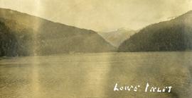
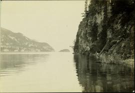
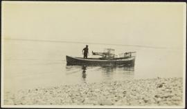
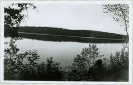
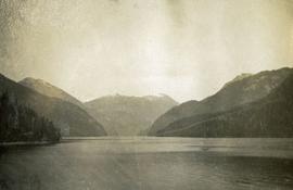
Photograph depicts of Lowe Inlet BC from the water looking toward the mountains.
Photograph depicts a view from the water of Lowe Inlet.
Image depicts a view of the lower Cayoosh Valley.
Handwritten annotation on verso reads: "Lower end of canyon on Naas River. North of Prince Rupert". Forest and mountains visible on shore in distance.
Image depicts the lower end of the river channel leading to the Spectacle Lakes.
Image depicts two unknown individuals canoeing on the lower part of Spectacle Lake.
Handwritten caption beside this photo reads: "Placing Crusher Pinion; Pitman; weight approx. 20 tons". Man stands on top of a very tall, red peice of equipment believed to be a crusher pitman. Boom of crane is visible in foreground, and two other men stand on a high level of the crusher building. Crusher foundations, an unidentified building, and mountain in background.
Image depicts numerous condominiums somewhere in Mackenzie, B.C.
Image depicts several apartment buildings and the sign for a Gulf Gas Station in Mackenzie, B.C.
Image depicts a row of houses in Mackenzie, B.C.
Image depicts the frozen Morfee Lake just to the East of Mackenzie, B.C. The slide is also labelled "sub-boreal," referencing that it is a sub-boreal spruce zone.
Image depicts a row of houses in Mackenzie, B.C.
Image depicts a trailer park somewhere in Mackenzie, B.C.
Image depicts a trailer park in Mackenzie, B.C.
Image depicts a truck parked on a beach in Mackenzie, B.C.
Image depicts a small section of Mackenzie, with the Mackenzie Curling Rink visible on the right side of the image.
Image depicts numerous vehicles in the parking lot of a mall in Mackenzie, B.C.
Image depicts the Mackenzie Reservoir in Mackenzie, B.C.
Image depicts several buildings along the main street in Stewart, B.C. One of them has been boarded up.
Image depicts several buildings along the main street in Stewart, B.C.
Image depicts the main street of Stewart, B.C.
Photograph depicts the main street of Rolla with a dirt street and wooden sidewalks, tethered horses, and the storefront of H.G. Atkinson General Merchants. Three people are visible walking through the streets.
Hand coloured photo of Main Street in Prince Rupert, with various tents and buildings on either side of the wooden road. Printed annotation on recto reads: "Main Street, Prince Rupert, B.C. : On comparatively Level Line London to Yokohama." Artist's mark on lower right corner reads: "104,035 J.V."
Photograph depicts a group of men standing near a building with the sign, "James Reid Ltd. General Merchants". There are a few fences and buildings in the background.
Photograph depicts a view of main street Grand Forks BC.
Photograph depicts a view of main street Grand Forks, BC. There are power poles in the center of the photograph, buildings line the street
Photograph depicts a view of main street Grand Forks, BC.
Photograph depicts a billboard size sign on the side of a building in Grand Forks BC.
Photograph depicts a view of main street Grand Forks, BC.
Item is a map annotated in colour by the City of Prince George Planning Department depicting major residential development proposals from June 1975 to August 1977 in the City of Prince George. This map was drawn for the City of Prince George interim Community Plan.
Photograph depicts the Mamquam River near Squamish.
Image depicts a man, with what is possibly the Robson Glacier visible in the background.
Image depicts a man, possibly Kent Sedgwick, standing next to a monument which states: "In honour of the pioneers of the Ootsa Lake Valley, first settled in 1905." Located somewhere in either the Francois Lake Provincial Park or the Wistaria Provincial Park.
Photograph depicts a man bathing himself while standing in a small metal tub. Photograph description in album notes this as "His 'Semi Annual'" [bath]. On the left is a log structure, presumably a cache building. A large clearing surrounds the building and bathing man. There is a forest and bluff in the background. Possibly located near Giscome Portage.
Typed annotation on recto: "Stuart Lake B.C." Man standing in water close to cliff which is reflected in water on right. Hills on opposite shore can be seen in background.
Typed annotation on recto: "Stuart Lake Scene - British Columbia." Man stands in water close to cliff which is reflected in water on right. Hills on opposite shore can be seen in background.
Typed annotation on recto: "Tachi River, Stuart Lake, B.C." Man in tall hat, smoking from a pipe, and standing on shore with fishing rod extended over water. Tree-covered banks in background.
Photograph depicts canoe floating in water, rocky shore in foreground, opposite shore visible on horizon.
Image depicts an unknown individual reading inside a tent somewhere in Mt. Robson Provincial Park.
Unidentified man can be seen walking on railroad tracks on far right. Utility poles, field, small building and background hills are visible in image.
Image depicts a man leaning on a rock somewhere on Murray Ridge.
Image depicts an unidentified man standing on a wood bridge somewhere in South Tweedsmuir Provincial Park.
Photograph depicts a man using crutches, this person wears glasses. There is a forest in the background.
Image depicts an unknown individual climbing the side of a large boulder.
Photograph depicts one man seated in rear of canoe on still water. Trees on opposite shore in background. This man is believed to be a member of the Bourchier forestry crew.
Handwritten caption above this photo reads: "Sumit Lake." Photograph depicts man sitting facing lake among branches of trees in foreground, forest on opposite shore reflected in water.
Handwritten caption beside this photo reads: "Earth Cut". Photograph depicts a man in distance at top of steep slope of man-made embankment, trees in background. Tracks made my machinery are visible in dirt of the cut.
Photograph depicts a man standing near a very large driftwood root.