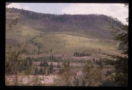
Image depicts an old road through the trees near Yellowhead Pass. The slide labels it as the origin of the Yellowhead highway.
Image depicts water flowing through an irrigation channel in an orchard, somewhere in or near Seton Portage, B.C. There is a sign which reads: "Danger Keep out."
Image depicts water flowing through an irrigation channel in an orchard, somewhere in or near Seton Portage, B.C.
Image depicts an open mining pit at an uncertain location; it is possibly Gibraltar.
Image depicts a field in Giscome, B.C. On the right side of the image, in the background, is a grey strip that appears to be a mine, possibly the quarry at Eaglet Lake in Giscome, B.C. Map coordinates 54°03'52.9"N 122°22'10.0"W
Image depicts an open field and Giscome, B.C. in the background. Map coordinates 54°03'52.9"N 122°22'10.0"W
Image depicts an open field and numerous buildings, including a church in Giscome, B.C. Map coordinates 54°04'03.2"N 122°22'04.6"W
Footage of a "stink box" used in Ooligan grease production in what is assumed to be Bella Coola. Also there is footage of some men fly-fishing on a river shore, either the Bella Coola River or the Dean River. There is a close-up clip of them baiting a hook, and then a shot of the men using gaff and hook to haul fish to shore. The men display their catch for the camera and there is a panoramic view of the mountains behind them. Included are some clips of Robson's deer, and a white robin.
Possible other locations in this film include the Atnarko region, Rainbow Mountains, Ulgoatcho Mountains and Chilcotin area.
Photograph depicts Onion Lake as seen through a barren tree line. In the background a mountain range surrounds the shores of the lake.
Image depicts a lake somewhere along what is possibly the Atlin Road to Atlin, B.C.
Front view of two men sitting on a pile of supplies with a mountain in the background. Printed annotation on recto reads: "On the Divide Enroute to Naas #96."
Image depicts a cabin on the "west arm" of Takla Lake.
Image depicts the "west arm" of Takla Lake.
Image depicts the "north-west arm" of Takla lake.
Image depicts a mountain and Takla Lake.
Image depicts a view of Takla Lake, "looking south-east."
Image depicts a view of Takla Lake, "looking north-west."
Image depicts a view of Takla Lake.
Image depicts several individuals walking on a trail somewhere near Raven Peak.
Image depicts four individuals canoeing on Lanezi Lake.
Image depicts two individuals canoeing on Lanezi Lake.
Image depicts an unknown individual in a canoe on Indianpoint Lake.
Image depicts Haida Gwaii.
Image depicts a bridge over the Omineca River near Germansen Landing, B.C.
Image depicts an old trestle along the White Pass railway.
Image depicts an old trestle along the White Pass railway, and the White pass Train on the left of the image.
Image depicts an old slump type of landslide. The slide labels it as being near "McAlister."
Image decpicts the old road to the townsite in Giscome, B.C. Map coordinates 54°04'19.7"N 122°22'04.7"W
Image depicts what appears to be an old mill at an unknown location.
Image depicts an old house missing windows and doors in the foreground, and a bunkhouse in the background, in Sinclair Mills, B.C. Map coordinates 54°01'17.4"N 121°40'53.0"W
Image depicts an old house in Penny and a woman, possibly Sue Sedgwick, standing in front of it. The location is uncertain.
Image depicts an old house with a torn up roof. The location is uncertain.
Image depicts an old house missing windows and doors at an uncertain location.
Image depicts Sue Sedgwick and a dog standing next to an old, collapsing cabin which is sloped sideways. The location is uncertain.
Image depicts an old, collapsing cabin which is sloped sideways. The location is uncertain.
Image depicts several old log cabins, possibly at McLeod Lake.
Image depicts an old cabin in the woods at an uncertain location.
Image depicts a couple of old buildings, and a field full of tree trunks and dead wood. Located somewhere in or around the Upper Fraser Canyon.
Image depicts several old buildings at an uncertain location. The slide is simply labelled "Spring house?"
Photograph of a long bridge spanning two rock faces. Below is a smaller, half demolished wooden bridge. A small settlement is visible on the lower right. Annotation on recto reads: "Haquelqet Bridge." Handwritten annotation on verso reads: "Old & New. Old Indian built bridge & later one at Hazelton, BC."
Image depicts a view of Old Aiyansh.
Image depicts an old, abandoned church located somewhere in Seton Portage, B.C.
Image depicts an old abandoned cabin at an uncertain location.