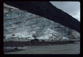
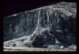
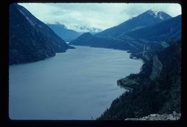
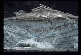
Image depicts a glacier at an uncertain location; the slide is labelled "after two days," and shows how much it has melted.
Image depicts a glacier at an uncertain location; the slide labels it as "avalanche glac."
Image depicts a glacier on the side of a road at an uncertain location; the slide labels it as "avalanche glac."
Image depicts a glacier at an uncertain location; the slide labels it as "avalanche glac."
Image depicts a mountain somewhere along what is possibly the Atlin Road.
Image depicts what is possibly Atlin Road. Numerous mountains are visible in the distance.
Image depicts a mountain, possibly Atlin Mountain.
Image depicts what is possibly Atlin Lake, with numerous mountains in the distance and Atlin Mountain visible on the right of the image.
Image depicts Atlin Lake as well as a small section of Atlin, B.C. The mountain is possibly Atlin Mountain.
Image depicts Atlin Lake.
Image depicts a boat named "the Tarahne," which is located in Atlin, B.C. Atlin Lake and Mountain are visible in the background.
Image depicts the post office in Atlin, B.C.
Image depicts an old boat on the shore of Atlin Lake.
Image depicts a building which once served as the residence for two nurses in Atlin, B.C. A sign in front of the house reads: "Grateful Atlinites built this house in 1902 for their first missionary nurses, Helen Bone and Elizabeth Mitchell, who came here in 1899 and lived in a crude shack while valiantly and humanely caring for sick and dying pioneers."
Image depicts numerous old buildings on a main street in Atlin, B.C.
Image depicts an old building undergoing a restoration process, possibly in Atlin, B.C.
Image depicts a back street in Atlin, B.C.
Image depicts a dock on the shore of Atlin Lake, as well as a building that may have once been a hospital. The slide is simply labelled "hospital."
Image depicts Ash Street and Patricia Boulevard in Prince George, B.C.
Image depicts numerous buildings on the shore of Haida Gwaii as the ferry approaches.
Image depicts what appears to be an apartment building among several others in an uncertain location.
Image depicts another train on the White Pass railway along a forested mountain side.
Image depicts a view of D'Arcy, located on the southern end of Anderson Lake.
Image depicts a vehicle on a bridge somewhere near Anderson Lake in the Seton Portage area.
Image depicts power lines running alongside Anderson Lake near Seton Portage, B.C.
Image depicts the Anderson Lake.
Image depicts a view of Anderson Lake near Seton Portage, B.C. A vehicle on a mountain road is also visible.
Image depicts a view of Anderson Lake near Seton Portage, B.C.
Image depicts the Alkali Lake Ranch in Alkali Lake, B.C.
Image depicts some farmland near Alexandria, B.C.
Image depicts the Alcan smelter in Kitimat, B.C.
Image depicts a small section of the Alaska Highway somewhere near Whitehorse, Y.T. The slide also appears to be labelled "army washing" for unknown reasons.
Image depicts the ferry to Alaska in the port of Prince Rupert, B.C.
Image depicts an old convenience store, with a sign on it labelled "Al Crosina." It is located at the 153 Mile House.
Image depicts a marker for aerial photography at an uncertain location. The slide labels it as "Elizabeth Station."
Image depicts an aerial view of a forest somewhere in the area of Divide Lake.
Image depicts an aerial view of the land in the area of Divide Lake.
Image depicts an old and abandoned, collapsing church at an uncertain location.
Image depicts an old, abandoned cabin with ivy growing up the side. The location is uncertain.
Image depicts an old and abandoned cabin with ivy growing up the side. The location is uncertain.
Image depicts a street in Wells, B.C. The Wells Hotel is present in the image.
Image depicts a street in Island Cache.