Fonds consists of textual, photographic, cartographic, electronic and promotional films/video recordings related to the mining operations of Cassiar Asbestos Mining Corporation (CAMC) and creation of Cassiar townsite. CAMC records primarily consist of records related to mining operations including construction, engineering, daily mining operations, administration of CAMC, tallies of extractions, labour and union activities, corporate events and visits by dignitaries. Townsite records are primarily visual representations of townsite construction, including the creation of health, education and community services including Cassiar's private hospital, school, library, as well as townsite images. Photographs include documentation of natural and man-made landscapes within the Cassiar region of Northern BC. Other holdings include a near complete run of Cassiar's community newspaper.
Sans titreThis blueprint depicts the general layout of the recreational centre. Top-down, side and front perspectives are used. The ground floor, second floor, outside walls and stage layouts are shown. Annotations in gold pen and pencil regarding clarification and changes to certain details are included. Numerical annotation at the bottom right hand of plan imposed new numbering system (3002/09/06).
This blueprint depicts the outside layout of the recreation centre and includes its north, south, east and west elevations. Details are included regarding the materials to be used for construction. Annotations in gold pen and pencil regarding clarification and changes to certain details are included. Numerical annotation at the bottom right hand of plan imposed new numbering system (3002/09/07).
This blueprint depicts a cross-section layout of the recreational centre which includes a 1/4 scale drawing of a wall unit. Annotations in gold pen and pencil regarding clarification and changes to certain details are included. Numerical annotation at the bottom right hand of plan imposed new numbering system (3002/09/09).
This blueprint depicts the overall framing structure of the recreational centre. Details include a cross section layout of the recreational centre with relevant framing dimensions, the locations and instructions for assembly as well as types of framing materials to be used. Annotations in gold pen and pencil regarding clarification and changes to certain details are included. Numerical annotation at the bottom right hand of plan imposed new numbering system (3002/09/10).
This blueprint depicts the gymnasium lighting layout. Also show is an isometric view of the air supply unit piping as well as a ventilating unit automatic control diagram. Included are detailed notes regarding system desriptions, its plan and layout as well as directions for the automatic control of the ventilation unit and heating systems. Annotations in gold pen and pencil regarding clarification and changes to certain details are included. Numerical annotation at the bottom right hand of plan imposed new numbering system (3002/09/12).
This blueprint shows the side profile of the proposed tramway to be built in Cassiar. It includes scale drawings of the crusher building, power house and support structures. The degree of tilt of the support structures are marked down where applicable. The side profile is divided into five sections due to the scaled height in elevation and the lack of drawing space. Annotation written along the leading edge of the blueprint reads "Proposed Tramway Riblet".
This blueprint shows the front and side profiles of the proposed jig back bucket for use in the tramway. Relevant measurements and dimensions are included as well as location placements for the track stand and traction rope.
This blueprint shows the top-down (showing the plan view) and the side view (showing elevation) of the transfer station layout. The process and operation of the jig back discharge and monocable loading are also included. Relevant measurements and dimensions are included as well as locations of the loading chute, the loading area, monocable as well as empty and loaded rope lines.
A set of 13 maps showing approximate waste extraction areas for different benches during certain months of 1972. Extraction dates are included accompanied by estimated total tonnages for each planned extraction area. All plans are hand drawn using colored pencils, lead and black ink. Approximate calculations of extraction tonnages are included within certain months. Numerical bench markers are included. Total tonnages from the previous year and previous surveys are included within certain plans.
This map depicts the generalized pit layout and estimated waste extraction areas for 6290 bench for the month of November. Annotated details include numerical bench markers and waste extraction dates. The hand drawn plan consists of solid and dotted lines drawn with green, orange, red, blue and lead pencil.
This map depicts the pit layout and estimated waste extraction areas for 6350 bench. Extraction dates accompanied by its total tonnages are located within each planned area. Annotated details include extraction dates, approximate total tonnages per area as well as extraction dates, total planned and broken tonnages and total tonnages from December 31, 1970 from a survey done in September 30. The hand drawn plan consists of solid lines drawn with red, green and orange colored pencils.
This map depicts the ore type and geology that can be found among each of the bench layers. Classifications and grades of ore are included within it. Different bench layers are included in the map. Annotations include a title in the back of the map written out as "1972 BENCH PLANS".
File contents relate to: Accounting / Payroll. Document type(s) include: invoices & balance sheets.
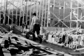
Photograph depicts man pushing wheelbarrow in framed building believed to be mill or power house. Wood planks in foreground, man and mountains in background.
Photograph depicts framework for truck dump. Mountain and power house framework believed to be in background.
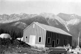
Photograph depicts power house, exterior finished. Man and building materials in foreground, oil tanks and mountains in background.
Photograph depicts snowy mountaintop, wooden shelter and truck in foreground. Corresponding note on accompanying photo description page: "Pictures taken July 2nd, 1952. 1. Picture taken from campsite showing snow on talus."
Photograph depicts two men in plant site, mountains in background. Corresponding note on accompanying photo description page: "Pictures taken July 3rd, 1952. 3. Quonset warehouse in background. Temporary set-up for circular saw in foreground."
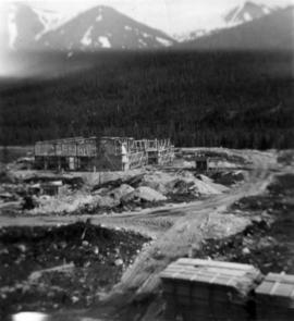
Photograph depicts mill building under construction, mountains in background. Corresponding note on accompanying photo description page: "Pictures taken July 3rd, 1952. 5. Mill. Truck Dump and concrete mixers in foreground. Taken from top of water tower and looking south."
Photograph depicts small building built into dirt landscape, mountains in background. Corresponding note on accompanying photo description page: "Pictures taken July 5th, 1952. 8. Root House. Looking north."
Photograph depicts man in distance on scaffolding. Corresponding note on accompanying photo description page: "Pictures taken July 5th, 1952. 11. Mill construction. Looking west."
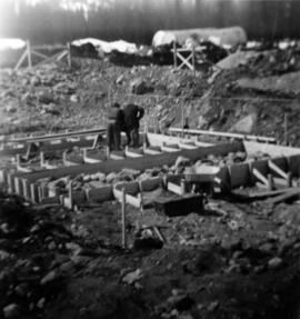
Photograph depicts men working on truck dump construction, mountains in background.
Photograph depicts two men on upper floor of building under construction, speculated to be mill building.
Photograph depicts two men on upper floor of building under construction, speculated to be mill building.
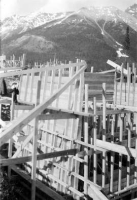
Photograph depicts interior framework of building under construction, mountains in background.
Photograph depicts mill building under construction, mountains in background. Photograph is speculated to be taken from top of water tower.
Photograph depicts men building truck dump in foreground, building believed to be power house in background. Corresponding note on accompanying photo description page: "Pictures taken June 11th: (3) Framing water tank tower. Water well in foreground and tower timbers and oil tanks in background. Looking east." [Note believed to be incorrect.]
Photograph depicts water tower framework. Building materials, truck, and oil tanks in foreground; mountains in background. Corresponding note on accompanying photo description page: "Pictures taken June 28th, 1952: (8) Water tower erection. Looking northwest."
Photograph depicts men on plant site. Corresponding note on accompanying photo description page: "Pictures taken June 28th, 1952: (9) Truck dump with concrete poured in foreground. Power house in background. Looking north from mill."
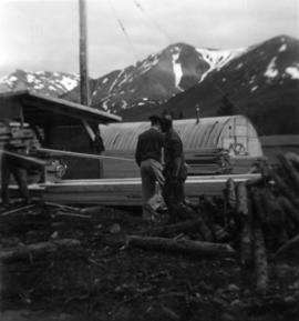
Photograph depicts black dog and tractor tire in foreground, ladder resting on side of quonset building, mountain in background. Corresponding note on accompanying photo description page: "Pictures taken June 28th, 1952: (12) Erecting quonset from Utah Camp. Located south of 30 KW power plant. looking southwest from No. 1 bunkhouse."
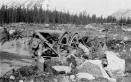
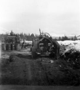
Photograph depicts track loader moving dirt in cleared area. It is believed that the loader may have been excavating area for ore haul truck dump (see item 2000.1.1.2.222). Trees and mountains in background.
Photograph depicts 7 men working on building speculated to be foundation for diesel engine. Oil tanks and mountains in background.
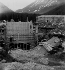
Photograph depicts 8 men and possibly 1 woman working in construction area, mountains in background. Corresponding note on accompanying photo description page: "2. Pouring concrete for second Ruston diesel engine. In foreground is the first diesel foundation stripped of concrete form ready for engine. Looking west."
Photograph depicts four buildings in trees at end of dirt road, mountains in background. Corresponding note on accompanying photo description page: "7. Prefab buildings for staff families and guest lodge. These buildings nearly completed."
Photograph depicts mountain side, semi-covered in snow. Snowbank in foreground. Corresponding note on accompanying photo description page: "8. Shows snow conditions in gully just north of talus deposit on south slope. Note considerable snow still above road. Estimated depth of snow here to be from 10 to 20 feet [see also item 2000.1.1.2.229]."
Photograph depicts man standing on dirt road. Snowbank to right of man is almost shoulder-height and disappears as road continues. Corresponding note on accompanying photo description page: "12. Indicates snow along the mountain road."
Photograph depicts four bunkhouse buildings leading to recreation hall at Watson Lake Airport. Power poles on left. Corresponding note on accompanying photo description page: "7. Same group of buildings as in picture No. 4 [see item 2000.1.1.2.236] showing steel building on the end [see item 2000.1.1.2.235]. Picture taken looking east. Note: There are at least as many more buildings again as shown in these snaps."
Photograph depicts 4 men working on early stages of mill construction, mountains in background. Corresponding note on accompanying photo description page: "9. Erecting wall posts on mill foundations. Looking west."
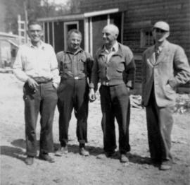
Corresponding note on accompanying photo description page: "1. Four staff members. L to R - Paisaud, Farewell, Hood, Ward - Taken in front of the office."
Photograph depicts foundation framework, trees and mountains in background. Corresponding note on accompanying photo description page: "7. Framing diesel engine foundations. Tarp overhead to keep out snow and rain. Oil tanks in background."
Photograph depicts 2 men working in building project area, trees in background. Corresponding note on accompanying photo description page: "1. Building concrete forms for diesel engine footings. Oil tanks in background."
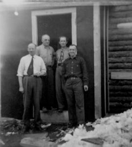
Photograph depicts four men in business attire (two wearing ties) in doorway of log office building. Pile of snow in foreground on right. Corresponding note on accompanying photo description page: "6. In front of office; L. to R. Duncan, Hood, Ward, Jenkyns." It is believed that these men may be staff members.
Photograph depicts scaffolding around garage, trees and mountainside in background. Men, steel drums and smaller white buildings can be seen around base of garage. Snow and dirt piles in mid ground, dog and steel drum in foreground. Corresponding note on accompanying photo description page: "8. Service garage nearly completed. Wide doors for taking bulldozers, and high enough to clear a van truck."
Photograph depicts group of men working in dirt area, snow and trees in background. Corresponding note on accompanying photo description page: "10. Pouring concrete at mill. Steamer for heating water in foreground, concrete mixer in background." Concrete mixer is behind four steel drums.
Photograph depicts framed garage in forested area. Snow in foreground, mountains in background. Corresponding note on accompanying photo description page: "3. Wall studding nearly completed - Service Garage."
Corresponding note on accompanying photo description page: "6. C. I-R 125 CFM. portable compressor. Northwest lumber piles in background." Trees and mountain also visible in background.
Corresponding note on accompanying photo description page: "7. Temporary buildings. First building is the cookery. Looking south." Photograph depicts numerous wood buildings down the left of snow-cleared dirt road, each with a small porch. The office and bunkhouse are also among the buildings (see item 2000.1.1.2.305). Wood piles lie in front of cookery, dump truck and dog can be seen at end of road, and another building is semi-visible on right. Tree-covered mountainside in background. See also items 2000.1.1.2.299 and 2000.1.1.2.301.
Photograph depicts a group of steel drums to right of large, flat, snow-covered area. A larger steel tank also lies behind drums on its side. A lumber pile can be seen in distance, as well as what appears to be a very large cylinder tank standing vertically under a shelter. Trees and mountains in background. See also item 2000.1.1.2.295.
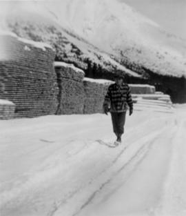
Photograph depicts a man walking in snow path, many lumber piles on his left. Mountain base in background.