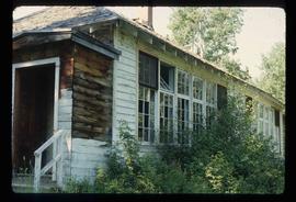
The item is a photograph of the front exterior of Knox United Church at 1425 5th Avenue, Prince George.
The item is a photograph of the front exterior of Knox United Church at 1425 5 Avenue, Prince George.
The item is a photograph depicting the exterior of the original Knox United Church built in 1922, located at the corner of Brunswick Street and 5th Avenue, Prince George. The photograph depicts the upper roof and chimney at the back of the church.
The item is a photograph depicting the exterior of the original Knox United Church built in 1922, located at the corner of Brunswick Street and 5th Avenue, Prince George. The photograph depicts the church entrance.
The item is a photograph depicting the original Knox United Church built in 1922, located at the corner of Brunswick Street and 5th Avenue, Prince George. The photograph depicts the front and side exterior of the church with some trees in front of the building.
The item is a photograph depicting the original Knox United Church built in 1922, located at the corner of Brunswick Street and 5th Avenue, Prince George. The photograph depicts the front and side exterior of the church.
Image depicts the historical village of 'Ksan near Hazelton, B.C.
Image depicts the 'Ksan historical village in Hazelton, B.C.
Image depicts the historical village of 'Ksan in Hazelton, B.C.
Image depicts a group of people in the historical village of 'Ksan near Hazelton, B.C.
Image depicts the entrance to the historical village of 'Ksan in Hazelton, B.C.
Image depicts a large gathering of people in the interior of a First Nations' longhouse located in the historical village of 'Ksan in Hazelton, B.C.
Image depicts a totem pole in the historical village of 'Ksan near Hazelton, B.C.
Image depicts the Kwinitsa CNR station in Kwinitsa, along the Skeena River.
Image depicts the Kwinitsa CNR station, which is Prince Rupert's railway museum.
Image depicts the La Tienda Hair and Nail Salon on an uncertain street somewhere in Prince George, B.C.
Image depicts the Lajoie Dam on the Bridge River, upstream side, showing part of Downton Lake and, in the foreground, the spillway intake.
Image depicts the Lajoie Dam on the Bridge River from the upstream side.
Image depicts the Lajoie hydroelectric generating station at the Lajoie Dam on the Bridge River (view of powerhouse and tailrace from top of dam).
Image depicts a lake with numerous buildings along the shore. The location is uncertain.
Image depicts a lake with lily pads somewhere on Haida Gwaii.
Image depicts a lake with a "Swim at Own Risk" sign at an uncertain location.
Image depicts a lake and a cabin at an uncertain location.
Image depicts an aerial view of a lake and large, forested areas. The location is uncertain.
Image depicts a lake and a mountain in the distance. The location is uncertain.
Image depicts an aerial view of a lake, and what appears to be a set of railway tracks running towards the mountains in the distance. The location is uncertain.
Image depicts an aerial view of several lakes and their surrounding areas at an uncertain location.
Image depicts an aerial view of a lake and the surrounding area at an uncertain location.
Image depicts a camper on the shore of what is possibly Melita Lake, near the Tseax Cone.
Image depicts the Lakeland Sawmill in Prince George, B.C, identified by the beehive burners; the one with white smoke belonged to Pas Lumber Co. which was bought out by Lakeland in 1987.
Image depicts the Lakeland Sawmill in Prince George, B.C.
Image depicts a large group of people enjoying the Mount Layton Hot springs in the Lakelse Lake Provincial Park north of Kitimat, B.C.
Image depicts a boarded-up house in Lamming Mills, B.C.
Image depicts an old, boarded-up store/office in Lamming Mills, B.C.
Image depicts the old, boarded-up community hall in Lamming Mills, B.C.
Image depicts several boarded-up houses in Lamming Mills, B.C.
Image depicts several old houses and an old, yellow pick-up in Lamming Mills, B.C.
Image depicts what appears to be the old, abandoned mill in Lamming Mills, B.C.
Image depicts what appears to be a part of the old, abandoned mill in Lamming Mills, B.C.
Image depicts a Yellowhead Realty sign in Lamming Mills, B.C. It reads: "For Sale, entire community, 50 buildings, 60 acres."
Image depicts a small section of the area surrounding Lamming Mills, B.C.
Image depicts the old school building in Lamming Mills, B.C.
Image depicts a view of a mountainous landscape at an uncertain location.
Image depicts a view of the landscape in an uncertain location, though possibly somewhere near the Fraser River.
Photograph depicting a landscape with a lake and a mountain in the background.
Image depicts a view of the landscape of the Chilcotin Wildlife Area.