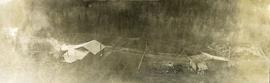
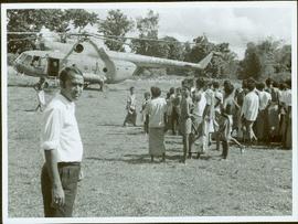
Item is a photograph of people, mostly children looking at a helicopter in a field.
Photograph depicts packed horses walking in single file across an alpine meadow.
Photograph depicts a newly cleared field, forest and mountains in the background.
Photograph depicts a stump in the foreground, a building in the midground and forested mountains in the background.
Photograph depicts a field in the foreground, forest and mountains in the background.
Photograph depicts a field in the foreground, buildings and stumps in the midground and forest in the background.
Photograph depicts a newly cleared field, forest and mountains in the background.
Photograph depicts three or more people bathing in a stream surrounded by forest.
Handwritten annotation on slide casing reads: “behind hotel Costa do Sol”.
Photograph is one of seven images believed to have been taken on a Canadian University Service Overseas (CUSO) mission in Mozambique; see also items 2009.6.1.483 - 2009.6.1.489.
Photograph depicts bears in captivity.
Photograph depicts bears in captivity. The large bear is chained by a neck collar.
Image depicts Sue and Kent Sedgwick with two dogs, standing with the Bear Glacier in the background.
Image depicts Sue Sedgwick with a dog, standing with the Bear Glacier in the background.
Photograph depicts the bow of a boat in the foreground, lake water and low treed hills in the background.
Rev. William Edwin Collison stands in centre of boat, with wife Bertha and daughters Muriel and Katherine seated behind. Unknown man and woman are also seated in boat, and an unknown man stands on shore holding rope.
Handwritten annotation on verso reads: "Will Collison with wife & children leaving Metlakatla to catch steamship en route to England (1910)".
Photograph depicts a view possibly from a stage coach, fences and rolling hills with dry vegetation in the background.
Photograph depicts three men standing in a canoe with long poles. Canoe is floating in quiet river water, bluffs in the background.
File consists of notes and reproductions relating to bibliographic references about Fort Alexandria (later renamed Alexandria). Fort Alexandria was a trading post, ferry site, and steamboat landing in the North Cariboo, 45 km south of Quesnel.
Photograph depicts two men, Bill Martin and Clarence Waldof, picking blueberries along a hillside surrounded by their bags and a dog.
Photograph of Cassiar's Chief Geologist Bill Plumb who led many exhibitions for the purposes of Cassiar's outside exploration endeavors. Various photos in this collection depict Bill on some of these exhibitions.
Photograph depicts a view from the railroad looking toward the river and mountain beyond at Billings siding.
Photograph depicts a view of the Blackwater bridge from downstream. The cabin, house and telegraph poles in the background.
Photograph depicts a view from above the Blackwater telegraph cabin and house. The house has a large fence garden beside, telegraph poles with wires are visible alongside the dirt road. Wood smoke drifts from the house chimney to the sparsely forested area beside.
Photograph depicts a canvas tent and wooden tent frame in the foreground, more canvas tents erected in the background. Two men carry poles on the right, while another man in center photo stands near another pole frame. There is a body of water in the background.
Photograph depicts three men standing on a bridge in the foreground, a cabin and fenced house in the midground, sparsely forested hills in the background. There are telegraph poles with wires between the bridge, cabin and house.
Photograph depicts a body of water surrounded by sparsely forested hills and low mountains.
Photograph depicts the Blackwater bridge and cabin. The forest in the foreground has been roughly cleared.
Photograph depicts a large body of water the shore edged with forest and low hills.
Photograph depicts two men pulling a boat through a shallow section of Crooked River in front of a forested landscape.
Item consists of transcript of interview with writer, film maker, and guide outfitter Andy Russell conducted by Bob Harkins at Prince George Radio Station, CJCI regarding Russell's experiences with guiding in Northern Rockies. Russell also discusses his new work The Life of a River and discusses the environmental impact of hydro-electric development on rivers
Harkins, BobItem consists of transcript and tape summary of interview with trapper Hank Witter who discusses his life as a trapper in Northern BC. c.1920s-c.1960s.
Harkins, BobItem consists of transcript of interview with writer and guide outfitter Jack Boudreau conducted by Bob Harkins at Prince George Radio Station, CJCI regarding Boudreau's experiences with grizzly bears. Boudreau also discusses other guide outfitters and hunters from Northern British Columbia.
Harkins, BobItem consists of transcript of interviews with various guests including Bob Crosby, manager of the Simon Fraser Hotel; Sammy Labadiere (sp?); and Prince George resident Chuck Williams discussing the re-enactment of the Simon Fraser voyage down the Fraser River in 1958.
Harkins, BobPhotograph depicts two men standing in center foreground, forested flat land in background.
Photograph depicts forest growth near Woodpecker Island and Stone Creek.
Photograph depicts forest growth with fallen trees and remnants of a forest fire.
Photograph depicts A cluster of boats anchored on the edge of a stream, some men standing on shore. Photograph is dark and blurry.
Photograph depicts a bow of a boat in the foreground. Thick ice on the edges of the river, water with floating ice beyond the boat. Trees lines the shoreline.
Photograph depicts three men in a boat using long poles to steer a boat through an ice covered river section at Finlay Forks.
Photograph depicts five men carrying shovels, walking through the snow in single file.
File consists of printed emails and typed documents relating to Brett & Hall and an exhibit for the National Gallery of Canada. Brett & Hall were landscape architects from Boston, MA who designed the original plan for Prince George, including features such as the Crescents neighbourhood.
File consists of notes and reproductions relating to Brett and Hall city planning work for Prince George. Brett & Hall were landscape architects from Boston, MA who designed the original plan for Prince George, including features such as the Crescents neighbourhood.
Photograph depicts a view of a small bridge and dirt road joining buildings on two sides of a river. Loaded packhorses are traveling down the road. There are mountains in the distance. Survey of 55th parallel.
Photograph depicts a rustic bridge covered in snow leading across a log jam. A horse is walking on the bridge toward the photographer. [55th parallel]
Photograph depicts a trail through log jam built by survey party. [55th parallel]
Photograph depicts two horses loaded with packs walking across a wooden bridge leading over Wedge Creek.
Photograph depicts the bridge at Goodacre Pond in Beacon Hill in Victoria, BC. Duck in foreground.
Photograph depicts the bridge at Goodacre Pond in Beacon Hill in Victoria, BC. Swans are swimming in the pond and there is a path and footbridge behind the pond.
Photograph depicts bridge built with wooden planks and poles, with triangles built into its frame. Water rapids in foreground, opposite shore in background behind bridge. This is speculated to be one of the bridges that crossed the Hagwilget Canyon on the Bulkey River since 1859, five kilometres from its confluence with the Skeena River. See items 2009.5.1.69 - 2009.5.1.71.