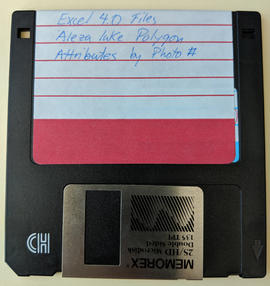
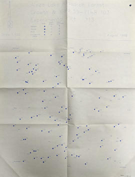
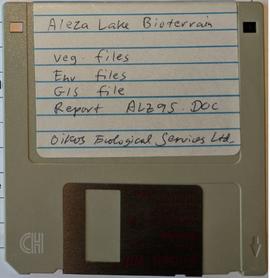
Floppy contains the following files: AL94ENV.DAT, AL94VEG.DAT, ALZZ95.DOC, GISDAT.XLS.
Item is a photograph of a copy print that has been reproduced as a slide, resulting in low photographic quality. Location of original photograph unknown.
Item is a photograph of a copy print, resulting in a low quality photographic reproduction. Reproduced as a print, slide, and a negative. Location of original photograph is unknown.
Map reflects reserve boundary, roads, trails, 20 feet contour intervals, air photo centre, declination, swamps, and mile post at the Aleza Lake Experiment Forest.
Map reflects reserve boundary, roads, trails, 20 feet contour intervals, air photo centre, declination, swamps, and mile post at the Aleza Lake Forest Reserve.
Item is a photograph of a copy print that has been reproduced as a slide, resulting in low photographic quality. Location of original photograph unknown.
Map reflects lot and STL lines, timber sale boundaries, Highway 16, roads, beetle infested areas, and plots X91971 to X91980, and X89946.
Item is a copyprint reproduced from the British Columbia Forest Service photographic records held at BC Archives.
Item is a photograph of a copy print, resulting in a low quality photographic reproduction. Reproduced as a print, slide, and a negative. Location of original photograph is unknown.
Item is a photograph of a copy print that has been reproduced as a slide, resulting in low photographic quality. Location of original photograph unknown.
The improvised forest fire "lookout shows up in the background. A small experimental nursery is in the foreground." --from the notes of Ralph Schmidt in accompanying file
Item is a photograph of a copy print that has been reproduced as a slide, resulting in low photographic quality. Location of original photograph unknown.
Back, left to right: Pinker, Rigler, Frank Dickson, Jack Freeborn
Front, left to right: Proste, Eric Garman, John Gerlitsky, Herbert (Ray) Sansom
Item is a photograph of a copy print, resulting in a low quality photographic reproduction. Reproduced as a print, slide, and a negative. Location of original photograph is unknown.
Item is a photocopied and annotated Aleza Lake Forest map with forest cover labels.
Item is a photocopied Aleza Lake Forest map with forest cover labels annotated to show 1994 RFP study area.
Item is a photocopied Aleza Lake Forest map with forest cover labels, annotated to show 1995 sample transects.
Photograph depicts the Aleza Lake regional district garbage dump in October 1992.
Photograph is one of six depicting the Aleza Lake nursery in Spring 1964. Annotations note these photographs may be associated with EP433.
Item is a 3.5 in. floppy containing Excel 4.0 files for the Aleza Lake polygon attributes by photo number. Files include: ALEZAENV.DAT, ALEZAENV.DOC, ALEZAPRO.DOC, ALEZASS.SRT, ALEZAVEG.DAT, ALEZAVEG.DOC, EDATOPE.CDR, FIELDF.XLS, POLY059.XLS, POLY061.XLS, POLY063.XLS, POLY101.XLS, POLY103.XLS, POLY105.XLS, POLY107.XLS, POLY127.XLS, POLY140.XLS, POLY142.XLS, POLY144.XLS, POLY146.XLS, POLY148.XLS, PROFILE.CDR.
Item is a photograph of a copy print that has been reproduced as a slide, resulting in low photographic quality. Location of original photograph unknown.
Map accompanies “Aleza Lake Research Forest Management and Working Plan #2 Draft #3”.
Map commissioned from Ministry of Forests Prince George Region from Madrone Consultants shows Aleza Lake Research Forest Access and Access Management. Map is 3 of 6. Map shows the following road types: all weather 1-lane gravel road, dry weather road, and proposed road access. Also shows areas for parking/turnaround, toilets, and information signs.
Map commissioned from Ministry of Forests Prince George Region from Madrone Consultants shows Aleza Lake Research Forest ecosystems. Map is 5 of 6. Map shows many sub-types of the following ecosystem types: upland, lowland wet forest, wetlands, and the Bowron floodplain benches. Ecosystem classification and mapping by Oikos Ecological Services Ltd.