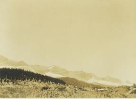
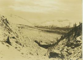
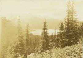
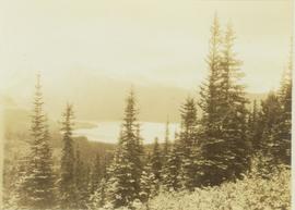
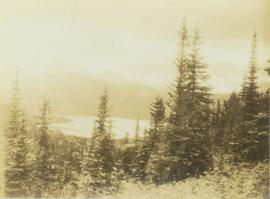
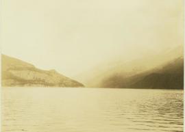
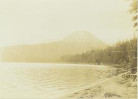
Photograph depicts the view looking north from Diamond Head Lodge in Garibaldi Park, about 20 miles northeast of Squamish. Believed to be "Bookworm range" at 7910 ft.
Image depicts a view of Prince George from Gunn Point in the L.C. Gunn Park looking north. Map coordinates 53°54'26.2"N 122°43'35.8"W.
Photograph depicts a view of the Peace River leading into a strait flanked by two forested shorelines. In the background a rocky cliffside is visible.
Photograph depicts a view of a snow-covered mountain range.
Photograph depicts a view of cannery buildings from the shoreline with mountains in the background.
Image depicts downtown Prince George taken from across the Nechako River looking south. Map coordinates 53°56'00.0"N 122°44'29.7"W
Photograph depicts the steep slope of man-made embankment, forest in background at bottom of slope. Small twigs and pant leg of unidentified individual in foreground.
Handwritten caption above this photo reads: "Earth Cut". Photograph depicts the steep slope of man-made embankment, trees in background. Tracks made my machinery are visible in dirt of the cut.
Photograph depicts the steep slope of man-made embankment. Forest in background, level excavated ground in foreground.
Photograph depicts the steep slope of man-made embankment, trees in background. Tracks made my machinery are visible in dirt of the cut.
Image depicts a view of Giscome with a train passing through.
Photograph depicts a view of the Hudson's Hope ferry seen from across the river. Behind the ferry, in the background is a rocky cliff face.
Image depicts a view of the small town of Likely, B.C.
No annotation on slide.
Annotation on slide: "Lucille Mt. from Mt. Teare, Susan Stevenson, July 1994"
Photograph depicts a view of a mountainous, tree-covered landscape and valley as seen through a mountain pass.
Image depicts a view of Pine Pass on the border between Alberta and British Columbia in the Rocky Mountains.
Photograph depicts Port Simpson in winter. Water crosses midground, hills stand in background.
Handwritten photo caption below image reads: "Port Simpson".
Annotation on photograph verso: "View SE from Jtn of A Road and Main Road. Uncut stand on left; selection logging virtually complete in centre and right. 15/1/92. Summit Lake Selection Trial"
Image depicts a view of Quesnelle Forks and the nearby river.
Photograph depicts a view of a snow-covered mountain range.
Photograph depicts a view of a snow-covered mountain range in the distance from a forested plateau.
Winter scene with buildings, street, and utility poles. Hill in background.
Handwritten annotation on verso: “South Ft. George 1912”.
View of the road descending to the waterfront. Buildings and forested area are visible on either side of street. Mountains clear in the background.
Annotation on photograph verso: "July-Aug. 1991, View of Summit Lake EP 1162. Area from top of Teapot Mountain, looking east. Trial area is east of Crooked River, north of Caine Creek [Forest Service] Road, south of gravel pit (on right)".
No annotation on slide.
Annotation on slide: "Summit Lake trial, Teapot Mountain, Jull".
Image depicts a view of Tabor Mountain in Prince George, B.C.
Handwritten photo album caption below this photo reads: "Whitehorse, & Alaska Highway, from below R.C.A.F. Barracks." Photograph depicts the cityscape of Whitehorse in valley. Alaska Highway can be seen in left foreground behind road railings in mountainside.
Royal Canadian Air ForceImage depicts a view south, possibly of an abandoned grade for the BCR; possibly somewhere near Woodpecker, B.C.
Postcard overview of the Bulkley River running closely past the village of Telkwa. Handwritten annotation in pen on verso reads: "Don Choracy [?] Prince Rupert, B.C. c/o Wrathall's Photo Shop. Aug. 9 Lake Kaetlyn. We had to drive all the way to Telkwa the other nite for postcards, imagine. We were sure glad and surprised to see Jack & Dick drive in at 7 to-nite. Just like being home. We are having so much fun. The boys are out on Lake to-nite, went to visit Dr. Macdonald's me thinks. I have bad head cold so have to stay home first nite at home I've since we came, Dieks is taking me on Lake tomorrow I hope, Love Bea-P."
Photograph depicts a vista from the Canadian Rockies with patches of snow.
Image depicts a section of the Peace River blocked off by the W.A.C. Bennett Dam. The dam itself is not visible in the image.
Item is a photograph of construction of the W.A.C. Bennett Dam.
Handwritten annotation on recto of photograph: "Omineca Dist Walcott Suspension Bridge West Approach - looking East May 26 - 1932". Photograph depicts two white horses pulling a wagon in front of Walcott bridge. This bridge was moved from its original location in the Hagwilget Canyon, downstream from Walcott on the Bulkley River. It is a pedestrian bridge at the time of this photograph, though it was originally used by motor vehicles. Dirt road leading to bridge in foreground, with lumber and brush piles on either side. Trees and hills on opposite shore in background.
Photograph depicts Wapiti Lake and a mountain range seen behind the trees of a forested slope.
Photograph depicts Wapiti Lake and an unidentified mountain range as seen behind the trees of a forested slope.
Photograph depicts Wapiti Lake and an unidentified mountain range seen from behind the trees of a forested slope.
Photograph depicts Wapiti Lake with an unidentified mountain range in the background.
Photograph depicts Wapiti Lake as seen from the shoreline with an unidentified mountain in the background.