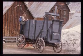
Image depicts a close-up of the carriage step. It is possibly located in Kamloops, B.C.
Image depicts a red carriage labelled in yellow "B.C. Express Co. No. 20." It is possibly located in Kamloops, B.C.
Image depicts a green canoe sitting in the water on the shore of Carp Lake.
Image depicts the Cariboo Road in Soda Creek, B.C.
Image depicts the Cariboo Road passing through the Cottonwood House Historic Site.
Image depicts the old, grown-over Cariboo Road at an uncertain location.
Image depicts the Cariboo Road south of Williams Lake.
Image depicts the Cariboo Road at Hat Creek Ranch, near Highway 99 on the way to Lillooet.
Image depicts the train station in Carcross, Y.T.
Image depicts a car on a dirt road leading through a forest.
Image depicts the Canadian National Railway Yards in Prince George, B.C.
Image depicts a man at a campsite somewhere near Murray Ridge.
Image depicts numerous campers and other vehicles in Tumbler Ridge, B.C.
Image depicts a stretch of road somewhere at Burns Lake, B.C.
Image depicts a stretch of road through the Bulkley Valley.
Image depicts a vehicle parked beside a small, wooden house in Upper Fraser, B.C. Map coordinates 54°07'05.7"N 121°56'38.9"W
Image depicts an aerial view of the BC Rail, in Prince George, B.C. It is now known as CN Rail.
Image depicts the entrance to a mine with an unknown individual present. It is possibly the entrance to the closed Britannia Mine in the Howe Sound Region.
Image depicts several boats on what appears to be a river, and an old beehive burner in Penny, B.C.
Image depicts a boat docked inside what appears to be a type of boathouse, possibly located in Metlakatla near Prince Rupert, B.C.
Image depicts a riverboat on the Fraser River, possibly in Longworth, B.C.
Image depicts Bellos Road, most likely in Red Rock, B.C.
Image depicts a beehive burner, as well as rail road tracks, at an unknown location.
Image depicts a section of road running through the Bear River Gorge.
Image depicts the BCR tracks passing through a mill somewhere near the 100 Mile.
Image depicts a freight wagon in Barkerville.
Image depicts a boat on Babine Lake, taken from Granisle, B.C.
Image depicts a glacier on the side of a road at an uncertain location; the slide labels it as "avalanche glac."
Image depicts what is possibly Atlin Road. Numerous mountains are visible in the distance.
Image depicts a boat named "the Tarahne," which is located in Atlin, B.C. Atlin Lake and Mountain are visible in the background.
Image depicts old machinery, at the Atlin Museum in Atlin, B.C.
Image depicts an old boat on the shore of Atlin Lake.
Image depicts numerous old buildings on a main street in Atlin, B.C.
Image depicts Ash Street and Patricia Boulevard in Prince George, B.C.
Image depicts another train on the White Pass railway along a forested mountain side.
Image depicts a vehicle on a bridge somewhere near Anderson Lake in the Seton Portage area.
Image depicts a view of Anderson Lake near Seton Portage, B.C. A vehicle on a mountain road is also visible.
Image depicts a small section of the Alaska Highway somewhere near Whitehorse, Y.T. The slide also appears to be labelled "army washing" for unknown reasons.
Image depicts the ferry to Alaska in the port of Prince Rupert, B.C.
Image depicts a road somewhere in Tumbler Ridge, B.C. There are numerous construction vehicles present.
Image depicts a road somewhere in Tumbler Ridge, B.C. There are three bush planes in the image.
Image depicts an elevated view of a lake and a road located somewhere near Bralorne, B.C.
Image depicts a house in Island Cache. There are several cars parked outside it.
Image depicts a stretch of highway, possibly Highway 29 or 97.
Image depicts what appears to be a ferry crossing a river at an uncertain location.
Image depicts a camper and a man and woman at an uncertain location, possibly somewhere near Meldrum Creek, B.C. The woman in the image is Sue Sedgwick.