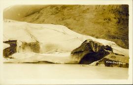
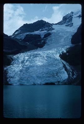
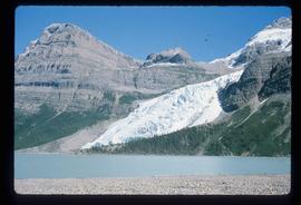
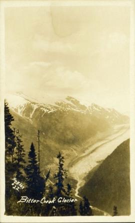
Image depicts Bear Glacier in the foreground and numerous mountain peaks in the background in Bear Glacier Provincial Park.
Image depicts Sue and Kent Sedgwick with two dogs, standing with the Bear Glacier in the background.
Image depicts Sue Sedgwick with a dog, standing with the Bear Glacier in the background.
Image depicts the Bear Glacier stretching through a mountain range.
Image depicts a dog on a road, and a view of the mountains in Bear Glacier Provincial Park.
Image depicts a view of Bear Pass, likely from Glacier Highway and somewhere in or near Bear Glacier Provincial Park, located north-east of Stewart, B.C.
Image depicts what is possibly Bear River in the Bear Glacier Provincial Park.
Image depicts the Bear River.
Image depicts what is possibly Bear River in the Bear Glacier Provincial Park.
Image depicts what is possibly Bear River, flowing out from an opening in the Bear Glacier.
Image depicts what is possibly Bear River flowing past what is likely a section of the Bear Glacier.
Image depicts a section of road running through the Bear River Gorge.
Photograph depicts the bow of a boat in the foreground, lake water and low treed hills in the background.
Image depicts the canoe group preparing to canoe on Beaver Pond, which is the start of Kibbee Lake.
Image depicts a field of hay somewhere in Beaver Valley.
Image depicts what appears to be a small ranch. The slide is labelled "Becher's Prairie," possibly meaning Becher's Prairie Provincial Park in B.C.
Image depicts an esker at Bednesti Lake, B.C.
Image depicts a beehive burner, as well as rail road tracks, at an unknown location.
Image depicts a Beehive Burner along the Nechako on River Road. Map coordinates 53°55'34.1"N 122°44'58.0"W
Foreground shows two rocky shores covered in dirt and wood debris, connected by a barely visible bridge. Annotation on recto reads: "Before the Blast Apr. 24th 13"
Image depicts Bellos Road, most likely in Red Rock, B.C.
Image depicts the Berg Glacier at Berg Lake in the Mt. Robson Provincial Park.
Image depicts the Berg Glacier and Berg Lake near Mt. Robson.
Rev. William Edwin Collison stands in centre of boat, with wife Bertha and daughters Muriel and Katherine seated behind. Unknown man and woman are also seated in boat, and an unknown man stands on shore holding rope.
Handwritten annotation on verso reads: "Will Collison with wife & children leaving Metlakatla to catch steamship en route to England (1910)".
Photograph depicts a view possibly from a stage coach, fences and rolling hills with dry vegetation in the background.
Photograph depicts three men standing in a canoe with long poles. Canoe is floating in quiet river water, bluffs in the background.
Image depicts two individuals on a canoe on Big Bar Lake north of Clinton, B.C..
Image depicts the a flock of ducks on Big Bar Lake north of Clinton, B.C..
Photograph of a large explosion on what appears to be a shoreline. Printed annotation on recto reads: "'Big Blast' Prince Rupert. B.C."
Photograph depicts the "Big Slide" at Lillooet. Also visible are a horse-drawn cart and the Fraser River.
Photograph depicts Bill and canoe on sandy shore, river and opposite shore in background. Handwritten annotation on recto of photograph: "Billy Barnett at Giscome Portage."
Photograph depicts three men guiding canoe through water. Bushes and forest slash in foreground, bushes on swampy shore in background. Handwritten annotation on recto of photograph: "Bill Barnett at stern of canoe."
Photograph depicts William (Bill) Storie at location known as Limestone Mountain, southwest of Cassiar, B.C. Photo features profile of Bill, hands in pocket, Cassiar valley and mountains in background. Storie was a renowned prospector in the Cassiar area, and the new school at Cassiar was named for him in 1992.
Photograph depicts a view from the railroad looking toward the river and mountain beyond at Billings siding.
Photograph depicts a panoramic view of Stewart B.C. Annotation on front "Bird's Eye View" "Stewart, BC"
Aerial view of Prince George and surrounding forested area. Printed annotation on recto reads: "Prince George, B.C."
Typed message on front reads: “Happy Birthday Your Honour, You have a way of making each person you come in contact with feel so special, so we all want to wish you the happiest birthday year ever. Staff of Government House, October 18, 2002.” Signed by the staff of Government House.
Handwritten annotation on verso reads: “The Rock - I spent 6 years creating 6 gardens surrounding”.
Photograph of a large glacier. Printed annotation on recto reads: "Bitter Creek Glacier."
Wide angle perspective of the Bitter Creek glacier, with trees visible in the foreground. Printed annotation on recto reads: "Hughes #22 Bitter Creek Glacier."
Item is a hand drawn and coloured map by the City of Prince George Planning Department depicting the Blackburn neighbourhood development area's proposed sector plan in 1976.
Image depicts a view of Blackburn Schools, possibly taken from Tabor Mountain.
Image depicts a view of Blackwater in the country near Punchaw, B.C.