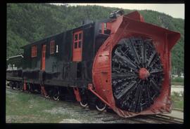
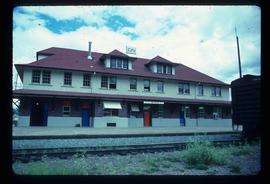
Image depicts the side of a train and the tracks it is on, somewhere in the Seton Portage area.
Image depicts a train in an uncertain location, though it is possibly Howe Sound in the background.
Image depicts a train in an uncertain location.
Image depicts a tractor with a claw lifting logs at a saw mill in Prince George, B.C.
Image depicts Highway 16 en route to Prince Rupert, B.C.
Image depicts half of a ship, which is named the Tutshi, in Carcross, Y.T.
Image depicts the Duchess engine, which was built in 1878 and taken out of service in 1919. It was part of a matched set with the Duke and is now a tourist attraction in Carcross, Y.T.
Image depicts a vehicle on a gravel road somewhere near Tête Jaune Cache, B.C.
Image depicts a rail road bridge located somewhere near Terrace, B.C.
Image depicts two bridges in Telkwa, B.C. One is for trains.
Image depicts a set of railway tracks, and a building with a sign which reads: "Telegraphs." The location is uncertain, but possibly in the Peace River Region.
Image depicts a trailer for a logging truck suspended off the ground by a wooden structure. This is used to load the trailer onto the back of the truck. The name on the truck says "Rormarniewich Trucking Ltd."
Image depicts a street in Giscome. The store was previously located on the left. The church is in the background. Map coordinates 54°04'18.5"N 122°21'57.7"W
Image depicts the BCR, as well as the Dunkley Lumber Mill, in Strathnaver, B.C.
Image depicts Stewart Harbour in Stewart, B.C.
Image depicts an unknown individual leaning against a sign at the Stewart Access Road which warns travellers to pack several days of food. Located in Hazelton, B.C.
Image depicts a man, possibly Kent Sedgwick, leaning against a sign forbidding public traffic on the Stewart Access Road from between 5 am to 8 pm. Located in Hazelton, B.C.
Image depicts a steep mountain road somewhere in the area of Seton Portage, B.C.
Image depicts the start of Joffre Creek Road, most likely somewhere in the Joffre Lakes Provincial Park.
Image depicts a large vessel docked in Prince Rupert, B.C. The name on its side is "Star Capella." The slide itself is labelled "superport."
Image depicts a fishing boat on the water somewhere near Prince Rupert, B.C. Only half of its name is visible: "spirit."
Image depicts the interior of the ferry at Southbank, B.C.
Image depicts what appears to be a Ranch at Soda Creek, B.C.
Image depicts the ferry at Soda Creek, B.C.
Image depicts a snow-covered road with vehicle tracks, and several houses. The location is uncertain.
Image depicts a road covered in snow running through the woods at an uncertain location.
Image depicts a snowy road at an uncertain location.
Image depicts a snow-covered road at an uncertain location.
Image depicts the restored White Pass Snow Plow No.1 in Skagway, Alaska.
Image depicts the CN rail station in Smithers B.C.
Image depicts a vehicle and a large group of skiers somewhere on Tabor Mountain in Prince George, B.C.
Image depicts two unidentified individuals examining a tractor meant to delimb trees. It is located in Prince George, B.C.
Image depicts the Skeena River, as well as a stretch of highway that appears to be under construction.
Image depicts the bus depot in Skagway, Alaska (USA).
Image depicts railway tracks and buildings with a beehive burner on the left. The location is likely Sinclair Mills, B.C. Map coordinates 54°01'17.4"N 121°40'53.0"W
Photograph depicts the Sinclair Mills community hall, it includes a sign in front of the building reading "Welcome to Sinclair Mills, Community Hall".
Image depicts a vehicled parked on the side of the road, with a view of the coast of Haida Gwaii in the background.
Image depicts several ships on the water in Prince Rupert, B.C.
Image depicts the train station in Seton Portage, B.C.
Image depicts the side of a train and the tracks it is on, as well as a small section of what is either Seton or Anderson Lake near Seton Portage, B.C.
Image depicts machinery in a saw mill somewhere in Prince George, B.C.
Image depicts the road to Skagway, Alaska. Possibly located on the Klondike Highway in British Columbia with Tutshi Lake on the left.
Image depicts a road leading to Prince Rupert, B.C.
Image depicts the dirt road leading to Keithley Creek.
Image depicts a mountain located somewhere along the Skeena River, and a road alongside it.
Image depicts a road with what appears to be a junkyard to the right of the image, likely located somewhere in Seton Portage, B.C.
Image depicts a ferry on a river, possibly the Fraser River in the Lillooet area.